Current Weather/Notams (Metars, TAFs, Notams, NWS Forecast, PIREPS, and nearby weather)
Customs Information Send updates to Support@FltPlan.com
Customs Not Available
Database effective 05/16/2024
Airport Diagram might not be current.
|
| Facility Name: | OCALA INTL-JIM TAYLOR FLD |
| City Name: | OCALA |
| County: | MARION |
| State abbrev: | FL |
| State Name: | FLORIDA |
| | |
| Ownership: | PUBLICLY OWNED |
| Use: | OPEN TO THE PUBLIC |
| Owner's Name: | CITY OF OCALA |
| Address: | 1770 SW 60TH AVENUE, SUITE 600 |
| | OCALA, FL 34474 |
| Owner's Phone: | 352-629-8377 |
| | |
| Manager's Name: | MATTHEW GROW |
| Address: | 1770 SW 60TH AVE, SUITE 600 |
| | OCALA, FL 34474 |
| Phone: | 352-629-8377 |
| | |
| FAA Region: | SOUTHERN |
| FAA Field Office: | ORL |
Runway Identifications
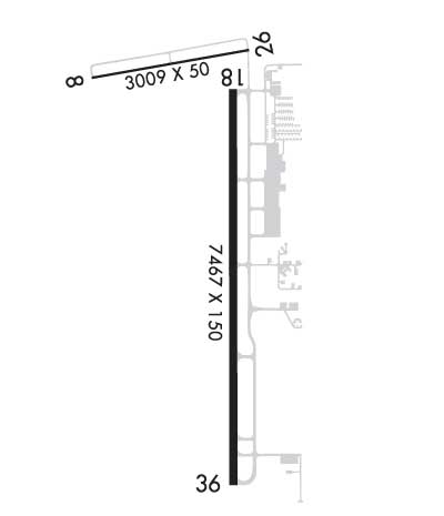
Runway Identification: 08/26Length: 3009 ft
Width: 50 ft
Surface: ASPHALT-GOOD CONDITION
Edge lights: Treatment: NONE
Weight: PCN 10 /F/A/Y/T
| | Runway: 08 | | Runway: 26 |
| Mag heading: | 84° | Mag heading: | 264° |
| Rwy Slope: | .03% Up | Rwy Slope: | -.03% Down |
| Approach: | | Approach: | |
| Pattern: | Left Traffic | Pattern: | Left Traffic |
| Markings: | BASIC | Markings: | BASIC |
| Marking Condition: | FAIR | Marking Condition: | FAIR |
| Arresting Dev: | | Arresting Dev: | |
| Lat & Long: | N2910.8 W08213.9 | Lat. & Long.: | N2910.9 W08213.3 |
| Elev: | 86.9 ft. MSL | Elev: | 87.8 ft. MSL |
| TCH: | | TCH: | |
| Visual Glide Path: | | Visual Glide Path: | |
| Displaced Threshold: | No | Displaced Threshold: | No |
| Touchdown Zone: | YES | Touchdown Zone: | YES |
| Touchdown Elev.: | 89.7 feet | Touchdown Elev.: | 89.7 feet |
| Visual Glide Slope: | | Visual Glide Slope: | |
| RVR Equipment: | | RVR Equipment: | |
| RVV Equipment: | NO | RVV Equipment: | NO |
| Approach Lights: | | Approach Lights: | |
| REIL: | NO | REIL: | NO |
| Centerline Lights: | NO | Centerline Lights: | NO |
| Touchdown lights: | NO | Touchdown lights: | NO |
| Runway Category: | Runway with a Visual Approach | Runway Category: | Runway with a Visual Approach |
| Declared Distances: | | Declared Distances: | |
| Obstructions: | TREES | Obstructions: | PLINE |
| Marked: | NOT Marked/Lighted | Marked: | NOT Marked/Lighted |
| Clearance slope: | 20:1 | Clearance slope: | 34:1 |
| Obstruction height: | 50 feet AGL | Obstruction height: | 25 feet AGL |
| Dist. from runway: | 1205 feet | Dist. from runway: | 1045 feet |
| Centerline offset: | 105 left of centerline | Centerline offset: | 170 feet left of centerline |
| Comments: | | Comments: | |
Runway Identification: 18/36Length: 7467 ft
Width: 150 ft
Surface: ASPHALT-GOOD CONDITION
Edge lights: High IntensityTreatment: GROOVED
Weight: PCN 43 /F/A/X/T
| | Runway: 18 | | Runway: 36 |
| Mag heading: | 184° | Mag heading: | 4° |
| Rwy Slope: | -.03% Down | Rwy Slope: | .03% Up |
| Approach: | | Approach: | ILS |
| Pattern: | Left Traffic | Pattern: | Left Traffic |
| Markings: | PRECISION INSTRUMENT | Markings: | PRECISION INSTRUMENT |
| Marking Condition: | FAIR | Marking Condition: | FAIR |
| Arresting Dev: | | Arresting Dev: | |
| Lat & Long: | N2910.7 W08213.4 | Lat. & Long.: | N2909.5 W08213.4 |
| Elev: | 80.1 ft. MSL | Elev: | 78.0 ft. MSL |
| TCH: | 45 ft. AGL | TCH: | 45 ft. AGL |
| Visual Glide Path: | 3.00 degrees | Visual Glide Path: | 3.00 degrees |
| Displaced Threshold: | 160 feet | Displaced Threshold: | 561 feet |
| Touchdown Zone: | YES | Touchdown Zone: | YES |
| Touchdown Elev.: | 80.3 feet | Touchdown Elev.: | 80.1 feet |
| Visual Glide Slope: | 4-Light PAPI on LEFT side of Runway | Visual Glide Slope: | 4-Light PAPI on LEFT side of Runway |
| RVR Equipment: | | RVR Equipment: | |
| RVV Equipment: | NO | RVV Equipment: | NO |
| Approach Lights: | | Approach Lights: | MALSR - 1,400 foot medium intensity approach lighting system with runway alignment indicator lights |
| REIL: | NO | REIL: | NO |
| Centerline Lights: | NO | Centerline Lights: | NO |
| Touchdown lights: | NO | Touchdown lights: | NO |
| Runway Category: | Precision Instrument Runway | Runway Category: | Precision Instrument Runway |
| Declared Distances: | TORA:7467' TODA:7467' ASDA:6717' LDA:6557' | Declared Distances: | TORA:7195' TODA:7195' ASDA:6907' LDA:6347' |
| Obstructions: | TREES | Obstructions: | TREE |
| Marked: | NOT Marked/Lighted | Marked: | NOT Marked/Lighted |
| Clearance slope: | 40:1 | Clearance slope: | 50:1 |
| Obstruction height: | 60 feet AGL | Obstruction height: | 46 feet AGL |
| Dist. from runway: | 2600 feet | Dist. from runway: | 2530 feet |
| Centerline offset: | 530 right of centerline | Centerline offset: | 410 feet right of centerline |
| Comments: | | Comments: | |

