Current Weather/Notams (Metars, TAFs, Notams, NWS Forecast, PIREPS, and nearby weather)
Customs Information Send updates to Support@FltPlan.com
Customs Not Available
Database effective 04/18/2024
Airport Diagram might not be current.
|
| Facility Name: | WOODBINE MUNI |
| City Name: | WOODBINE |
| County: | CAPE MAY |
| State abbrev: | NJ |
| State Name: | NEW JERSEY |
| | |
| Ownership: | PUBLICLY OWNED |
| Use: | OPEN TO THE PUBLIC |
| Owner's Name: | BOROUGH OF WOODBINE |
| Address: | 660 HENRY DECINQUE BLVD |
| | WOODBINE, NJ 08270 |
| Owner's Phone: | 609-861-1300 |
| | |
| Manager's Name: | ALEXANDER BAUER |
| Address: | 501 WASHINGTON AVENUE |
| | WOODBINE, NJ 08270 |
| Phone: | 609-861-5301 |
| | |
| FAA Region: | EASTERN |
| FAA Field Office: | HAR |
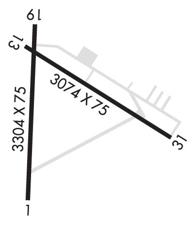
Runway Identifications
Runway Identification: 01/19Length: 3304 ft
Width: 75 ft
Surface: ASPHALT-FAIR CONDITION
Edge lights: Medium IntensityTreatment: NONE
| | Runway: 01 | | Runway: 19 |
| Mag heading: | 12° | Mag heading: | 192° |
| Rwy Slope: | .50% Up | Rwy Slope: | -.50% Down |
| Approach: | | Approach: | |
| Pattern: | Left Traffic | Pattern: | Left Traffic |
| Markings: | NONPRECISION INSTRUMENT | Markings: | NONPRECISION INSTRUMENT |
| Marking Condition: | FAIR | Marking Condition: | FAIR |
| Arresting Dev: | | Arresting Dev: | |
| Lat & Long: | N3912.8 W07447.8 | Lat. & Long.: | N3913.4 W07447.8 |
| Elev: | 24.5 ft. MSL | Elev: | 41.0 ft. MSL |
| TCH: | | TCH: | 21 ft. AGL |
| Visual Glide Path: | | Visual Glide Path: | 3.70 degrees |
| Displaced Threshold: | No | Displaced Threshold: | No |
| Touchdown Zone: | YES | Touchdown Zone: | YES |
| Touchdown Elev.: | 39.6 feet | Touchdown Elev.: | 41.0 feet |
| Visual Glide Slope: | | Visual Glide Slope: | 2-Light PAPI on LEFT side of Runway; PAPI HIGH INTST ONLY. |
| RVR Equipment: | | RVR Equipment: | |
| RVV Equipment: | NO | RVV Equipment: | NO |
| Approach Lights: | | Approach Lights: | |
| REIL: | NO | REIL: | YES |
| Centerline Lights: | NO | Centerline Lights: | NO |
| Touchdown lights: | NO | Touchdown lights: | NO |
| Runway Category: | Runway with a Non-precision Approach | Runway Category: | Runway with a Non-precision Approach |
| Declared Distances: | | Declared Distances: | |
| Obstructions: | TREES | Obstructions: | TREES |
| Marked: | NOT Marked/Lighted | Marked: | NOT Marked/Lighted |
| Clearance slope: | 3:1 | Clearance slope: | 12:1 |
| Obstruction height: | 31 feet AGL | Obstruction height: | 43 feet AGL |
| Dist. from runway: | 316 feet | Dist. from runway: | 768 feet |
| Centerline offset: | 158 left of centerline | Centerline offset: | 322 feet right of centerline |
| Comments: | | Comments: | |
Runway Identification: 13/31Length: 3074 ft
Width: 75 ft
Surface: ASPHALT-FAIR CONDITION
Edge lights: Medium IntensityTreatment: NONE
| | Runway: 13 | | Runway: 31 |
| Mag heading: | 132° | Mag heading: | 312° |
| Rwy Slope: | -.14% Down | Rwy Slope: | .14% Up |
| Approach: | | Approach: | |
| Pattern: | Left Traffic | Pattern: | Left Traffic |
| Markings: | BASIC | Markings: | BASIC |
| Marking Condition: | FAIR | Marking Condition: | FAIR |
| Arresting Dev: | | Arresting Dev: | |
| Lat & Long: | N3913.3 W07447.8 | Lat. & Long.: | N3913.1 W07447.3 |
| Elev: | 38.6 ft. MSL | Elev: | 34.3 ft. MSL |
| TCH: | 20 ft. AGL | TCH: | 25 ft. AGL |
| Visual Glide Path: | 3.00 degrees | Visual Glide Path: | 3.50 degrees |
| Displaced Threshold: | No | Displaced Threshold: | No |
| Touchdown Zone: | YES | Touchdown Zone: | YES |
| Touchdown Elev.: | 38.6 feet | Touchdown Elev.: | 38.4 feet |
| Visual Glide Slope: | 2-Light PAPI on LEFT side of Runway; PAPI HIGH INTST ONLY. | Visual Glide Slope: | 2-Light PAPI on RIGHT side of Runway; PAPI HIGH INTST ONLY. |
| RVR Equipment: | | RVR Equipment: | |
| RVV Equipment: | NO | RVV Equipment: | NO |
| Approach Lights: | | Approach Lights: | |
| REIL: | NO | REIL: | YES |
| Centerline Lights: | NO | Centerline Lights: | NO |
| Touchdown lights: | NO | Touchdown lights: | NO |
| Runway Category: | Runway with a Visual Approach | Runway Category: | Runway with a Visual Approach |
| Declared Distances: | | Declared Distances: | |
| Obstructions: | TREES | Obstructions: | TREES |
| Marked: | NOT Marked/Lighted | Marked: | NOT Marked/Lighted |
| Clearance slope: | 26:1 | Clearance slope: | 11:1 |
| Obstruction height: | 60 feet AGL | Obstruction height: | 24 feet AGL |
| Dist. from runway: | 1808 feet | Dist. from runway: | 481 feet |
| Centerline offset: | 206 left of centerline | Centerline offset: | 151 feet right of centerline |
| Comments: | | Comments: | |
