Current Weather/Notams (Metars, TAFs, Notams, NWS Forecast, PIREPS, and nearby weather)
Customs Information Send updates to Support@FltPlan.com
Customs Not Available
Database effective 05/16/2024
Airport Diagram might not be current.
|
| Facility Name: | OKEECHOBEE COUNTY |
| City Name: | OKEECHOBEE |
| County: | OKEECHOBEE |
| State abbrev: | FL |
| State Name: | FLORIDA |
| | |
| Ownership: | PUBLICLY OWNED |
| Use: | OPEN TO THE PUBLIC |
| Owner's Name: | OKEECHOBEE COUNTY; CONTACT PERSON: DEBORAH MANZO 863-763-6441 |
| Address: | 2800 NORTH WEST 20TH TRAIL |
| | OKEECHOBEE, FL 34972 |
| Owner's Phone: | 863-763-6441 |
| | |
| Manager's Name: | JOHN HURST |
| Address: | 2800 NW 20TH TRL |
| | OKEECHOBEE, FL 34972 |
| Phone: | 863-467-5505; EMERG - 863-634-1474 |
| | |
| FAA Region: | SOUTHERN |
| FAA Field Office: | ORL |
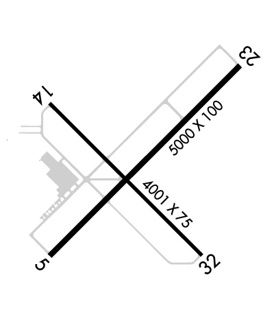
Runway Identifications
Runway Identification: 05/23Length: 5000 ft
Width: 100 ft
Surface: ASPHALT
Edge lights: Medium IntensityTreatment: NONE
| | Runway: 05 | | Runway: 23 |
| Mag heading: | 51° | Mag heading: | 231° |
| Rwy Slope: | .00% Down | Rwy Slope: | .00% Up |
| Approach: | | Approach: | |
| Pattern: | Left Traffic | Pattern: | Left Traffic |
| Markings: | NONPRECISION INSTRUMENT | Markings: | NONPRECISION INSTRUMENT |
| Marking Condition: | GOOD | Marking Condition: | GOOD |
| Arresting Dev: | | Arresting Dev: | |
| Lat & Long: | N2715.7 W08051.3 | Lat. & Long.: | N2716.3 W08050.7 |
| Elev: | 32.9 ft. MSL | Elev: | 32.8 ft. MSL |
| TCH: | 42 ft. AGL | TCH: | 43 ft. AGL |
| Visual Glide Path: | 3.00 degrees | Visual Glide Path: | 3.00 degrees |
| Displaced Threshold: | No | Displaced Threshold: | No |
| Touchdown Zone: | YES | Touchdown Zone: | YES |
| Touchdown Elev.: | 33.5 feet | Touchdown Elev.: | 33.5 feet |
| Visual Glide Slope: | 4-Light PAPI on LEFT side of Runway | Visual Glide Slope: | 4-Light PAPI on LEFT side of Runway |
| RVR Equipment: | | RVR Equipment: | |
| RVV Equipment: | NO | RVV Equipment: | NO |
| Approach Lights: | | Approach Lights: | |
| REIL: | YES | REIL: | YES |
| Centerline Lights: | NO | Centerline Lights: | NO |
| Touchdown lights: | NO | Touchdown lights: | NO |
| Runway Category: | Runway with a Non-precision Approach having visibility minimums greater than 3/4 mile | Runway Category: | Runway with a Non-precision Approach having visibility minimums greater than 3/4 mile |
| Declared Distances: | | Declared Distances: | |
| Obstructions: | TREE | Obstructions: | TREES |
| Marked: | NOT Marked/Lighted | Marked: | NOT Marked/Lighted |
| Clearance slope: | 47:1 | Clearance slope: | 28:1 |
| Obstruction height: | 40 feet AGL | Obstruction height: | 43 feet AGL |
| Dist. from runway: | 2040 feet | Dist. from runway: | 1430 feet |
| Centerline offset: | | Centerline offset: | 220 feet left of centerline |
| Comments: | | Comments: | |
Runway Identification: 14/32Length: 4001 ft
Width: 75 ft
Surface: ASPHALT-FAIR CONDITION
Edge lights: Treatment: NONE
| | Runway: 14 | | Runway: 32 |
| Mag heading: | 141° | Mag heading: | 321° |
| Rwy Slope: | -.02% Down | Rwy Slope: | .02% Up |
| Approach: | | Approach: | |
| Pattern: | Left Traffic | Pattern: | Left Traffic |
| Markings: | NONPRECISION INSTRUMENT | Markings: | NONPRECISION INSTRUMENT |
| Marking Condition: | FAIR | Marking Condition: | FAIR |
| Arresting Dev: | | Arresting Dev: | |
| Lat & Long: | N2716.2 W08051.3 | Lat. & Long.: | N2715.7 W08050.8 |
| Elev: | 33.0 ft. MSL | Elev: | 32.3 ft. MSL |
| TCH: | 40 ft. AGL | TCH: | 40 ft. AGL |
| Visual Glide Path: | 3.00 degrees | Visual Glide Path: | 3.00 degrees |
| Displaced Threshold: | No | Displaced Threshold: | No |
| Touchdown Zone: | YES | Touchdown Zone: | YES |
| Touchdown Elev.: | 33.5 feet | Touchdown Elev.: | 33.5 feet |
| Visual Glide Slope: | 4-Light PAPI on LEFT side of Runway | Visual Glide Slope: | 4-Light PAPI on LEFT side of Runway |
| RVR Equipment: | | RVR Equipment: | |
| RVV Equipment: | NO | RVV Equipment: | NO |
| Approach Lights: | | Approach Lights: | |
| REIL: | NO | REIL: | NO |
| Centerline Lights: | NO | Centerline Lights: | NO |
| Touchdown lights: | NO | Touchdown lights: | NO |
| Runway Category: | Runway with a Non-precision Approach | Runway Category: | Runway with a Non-precision Approach |
| Declared Distances: | | Declared Distances: | |
| Obstructions: | TREES | Obstructions: | FENCE |
| Marked: | NOT Marked/Lighted | Marked: | LIGHTED |
| Clearance slope: | 25:1 | Clearance slope: | |
| Obstruction height: | 34 feet AGL | Obstruction height: | 5 feet AGL |
| Dist. from runway: | 1060 feet | Dist. from runway: | 200 feet |
| Centerline offset: | 175 left of centerline | Centerline offset: | 215 feet left of centerline |
| Comments: | | Comments: | 5 FT FENCE 200FT FM RWY END 215 FT L. |

