
| ||||||||||||||||||||||||||||||||||||||||||||
| ||||||||||||||||||||||||||||||||||||||||||||
| ||||||||||||||||||||||||||||||||||||||||||||
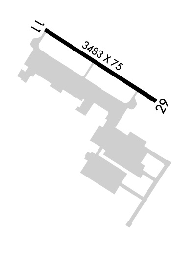
| Rwy | Rwy | |||||||
| 3483x75 | 3483' | 3483x75 | 3483' | |||||
| Runway ID | Single Wheel | Double Wheel | Double Tandem Wheel | Dual Double Wheel |
| 11/29 | 20,000 | 50,000 | N/A | N/A |
| These numbers are Advisory and are not limits. The Airport Manager should have more accurate Weight Limits | ||||
 Airport Diagram might not be current. | |
| Facility Name: | MARINA MUNI |
| City Name: | MARINA |
| County: | MONTEREY |
| State abbrev: | CA |
| State Name: | CALIFORNIA |
| Ownership: | PUBLICLY OWNED |
| Use: | OPEN TO THE PUBLIC |
| Owner's Name: | CITY OF MARINA |
| Address: | 211 HILLCREST AVE. |
| MARINA, CA 93933 | |
| Owner's Phone: | 831-884-1278 |
| Manager's Name: | MARISSA ORDUNO; JEFF CRECHRIOU, AIRPORT SERVICES MANAGER |
| Address: | 781 NEESON ROAD |
| MARINA, CA 93933 | |
| Phone: | 831-582-0102 |
| FAA Region: | WESTERN-PACIFIC |
| FAA Field Office: | SFO |
| Date | Sunrise | Sunset |
|---|---|---|
| 04/24/24 Wednesday | 6:20 | 19:50 |
| 04/25/24 Thursday | 6:19 | 19:51 |
| 04/26/24 Friday | 6:18 | 19:52 |
| 04/27/24 Saturday | 6:17 | 19:53 |
| 04/28/24 Sunday | 6:16 | 19:54 |
| 04/29/24 Monday | 6:15 | 19:55 |
| 04/30/24 Tuesday | 6:13 | 19:55 |
| 05/01/24 Wednesday | 6:12 | 19:56 |
| 05/02/24 Thursday | 6:11 | 19:57 |
| 05/03/24 Friday | 6:10 | 19:58 |
| 05/04/24 Saturday | 6:09 | 19:59 |
| 05/05/24 Sunday | 6:08 | 20:00 |
| 05/06/24 Monday | 6:07 | 20:01 |
| 05/07/24 Tuesday | 6:06 | 20:01 |
| Airport Attendance Schedule | MON - FRI 0800-1700 |
| Airport Status | OPERATIONAL (This Status can change at any time - please check NOTAMS) |
| Airport Lighting Schedule | ACTVT MIRL RWY 11/29 - CTAF 7 CLICKS. |
| Airport Storage Available | Tie Downs |
| Extra Services Available | Avionics, Parachute Jumping |
| Wind Indicator | YES - (lighted) |
| Control Tower | NO |
| CTAF Frequency | 122.700 |
| Unicom Frequency | 122.700 |
| Rotating Beacon Color | WG |
| Segmented Circle | YES |
| Landing Fee |
| Airport Inspected | STATE - performed by STATE AERONAUTICAL PERSONNEL |
| Inspection Date | 04/03/2024 |
| Type of Fuel Available | Grade 100LL, JET A (freeze point -40C); -10FUEL AVBL (100LL & JET A) 24 HRS VIA CREDIT CARD LOCK SYS. |
| Airframe Repair Service | MAJOR |
| Power Plant Repair Service | MAJOR |
| Latitude | N3640.9 |
| Longitude | W12145.7 (ESTIMATED) |
| Arpt Elevation | 136ft (SURVEYED) |
| Magnetic Variation | 15E |
| 2 miles NE | of MARINA |
| Traffic Pattern Altitude | |
| Sectional Chart | SAN FRANCISCO |
| Operations (Reported) | Yearly | Avg. Daily |
|---|---|---|
| General Aviation Transient | 28350 | 78 |
| General Aviation Local | 13650 | 37 |
| Air Taxi | 0 | 0 |
| Commerical | 0 | 0 |
| Commuter | 0 | 0 |
| Military | 0 | 0 |
| Aircraft based on Field | |
|---|---|
| General Aviation Singles | 34 |
| General Aviation Multi | 1 |
| Jet Aircraft | 0 |
| General Aviation Helicopters | 0 |
| Military Aircraft | 0 |
| Gliders | 0 |
| Ultralights | 2 |
| FSS on field | NO |
| FSS tie-in | OAKLAND |
| FSS Phone | 1-800-WX-BRIEF |
| Who issues Notams | OAK |
| Notam D service at airport | YES |
| ARTCC Name | OAKLAND |
| Airport Certification | |
| Aircraft Rescue & Firefighting Index | None |
| Airport of Entry | No |
| Custom Landing Rights | No |
| Joint Civil/Military | No |
| Military Landing rights | YES |
| NATIONAL PLAN OF INTEGRATED AIRPORT SYSTEMS (NPIAS) |
| THIS AIRPORT HAS BEEN SURVEYED BY THE NATIONAL GEODETIC SURVEY. |
| DEP RY 29 EXECUTE 45 DEGREE RIGHT TURN TO AVOID OVERFLIGHT OF NOISE SENSITIVE RESIDENTIAL AREA. |
| RY 29 CALM WIND RY. |
| ULTRALIGHT & SKYDIVING ACTIVITY ON AND INVOF ARPT. |
| SKYDIVING ACTIVITY ON SE SIDE OF AIRPORT |
| FOR CD CTC NORCAL APCH AT 916-361-3748. |
| 500 FT SWY DEP END RWY 29. |
Airport Communications & Frequencies:
| |||||||||||||||||||||
| Runway: 11 | Runway: 29 | ||
| Mag heading: | 107° | Mag heading: | 287° |
| Rwy Slope: | .00% Down | Rwy Slope: | .00% Up |
| Approach: | Approach: | ||
| Pattern: | Left Traffic | Pattern: | Right Traffic |
| Markings: | NONPRECISION INSTRUMENT | Markings: | NONPRECISION INSTRUMENT |
| Marking Condition: | GOOD | Marking Condition: | FAIR |
| Arresting Dev: | Arresting Dev: | ||
| Lat & Long: | N3641.0 W12146.0 | Lat. & Long.: | N3640.7 W12145.4 |
| Elev: | 136.4 ft. MSL | Elev: | 136.3 ft. MSL |
| TCH: | TCH: | 45 ft. AGL | |
| Visual Glide Path: | Visual Glide Path: | 3.00 degrees | |
| Displaced Threshold: | No | Displaced Threshold: | No |
| Touchdown Zone: | YES | Touchdown Zone: | YES |
| Touchdown Elev.: | 136.6 feet | Touchdown Elev.: | 136.6 feet |
| Visual Glide Slope: | Visual Glide Slope: | 2-Light PAPI on LEFT side of Runway; PAPI OPERS CONTINUOUSLY. | |
| RVR Equipment: | RVR Equipment: | ||
| RVV Equipment: | NO | RVV Equipment: | NO |
| Approach Lights: | Approach Lights: | ||
| REIL: | NO | REIL: | NO |
| Centerline Lights: | NO | Centerline Lights: | NO |
| Touchdown lights: | NO | Touchdown lights: | NO |
| Runway Category: | Runway with a Non-precision Approach having visibility minimums greater than 3/4 mile | Runway Category: | Runway with a Non-precision Approach having visibility minimums greater than 3/4 mile |
| Declared Distances: | Declared Distances: |
