Personal Attention to Passengers and Flight Crew.

KOAK

Whisper PlateWhisper Track
METROPOLITAN OAKLAND INTL
OAKLAND
CA
Time Zone: Pacific
Lat: N 3743.3
Long: W 12213.3
Elev: 9
Var: -14
Longest Runway: 10520
Clr Del: 121.1
Dept. ATIS: 133.77
Arr. ATIS: 133.77
Ground: 121.75/121.9
Tower: 127.2/118.3

FBO & Flight Services info for KOAK

FBOs: Update your Fuel Prices

  click here  
KaiserAir Oakland has provided uncompromising service to passengers, flight crews, and aircraft for over 75 years. Our safety record and attention to detail have earned recognition by the NBAA. CAA-preferred FBO. True full service including concierge service, experienced aircraft servicing, customs, immigration, and agricultural clearance, courtesy transportation, crew cars, and much more!
Ph: 800-538-2625 Fax: 510-569-9670 Freq: 129.75WebsiteE-Mail
                     
Service
Jet
100LL
SAF
MoGas
Fuel Avail: 24 hours, 365 days
Full6.217.89    Last Update: 04/16/2024 20:21
PRICES GUARANTEED by FBO.
Self        
Misc. Info: Volume discounts are available.Address: 8735 EARHART ROAD   OAKLAND, CA 94621

SIGNATUREPh: 510-633-1266 Fax: 510-430-8731 Freq: 130.57
Service
Jet
100LL
SAF
MoGas
Fuel Avail: PRIST+ $0.08/gal.
Full6.417.99    Last Update: 04/18/2024 12:04  
Self        
 Address: 8433 EARHART RD   OAKLAND,CA 94621
ATISPh: 510-635-5850
-
Freq: 133.77  
ASOSPh: 510-383-9514
-
-
 
If you are an FBO, call 1-203-262-1700 to update your info or email: FltPlan.Advertising@garmin.com
Advertise your FBO on FltPlan.com
FBOs at nearby airports who want your business:
KHWD


  click here  
BAY AREA'S BEST KEPT SECRET! Only minutes from OAK, SFO, and SJC. No landing fees. No commercial traffic. Great Service, low prices, NATA trained staff, beautiful lobby, and the smiles you deserve. Colt, UVair, World, Mariah, JFI, Mercury, Everest.
Ph: 1-510-259-1347WebsiteE-MailFax: 1-510-259-1959Freq: 129.72

Runway & Approach Info for KOAK
Rwy
Length
Land Dist**
Approach*
  Rwy
Length
Land Dist**
Approach*
10L
5457x150  5457'          
 
  
28R
  5457x150  5457'          
ILS
 109.90 - 278°  
10R
6213x150  6213'          
 
  
28L
  6213x150  6213'          
 
12
10520x150  10520'          
ILS
 111.90 - 115°  
  
30
  10520x150  10406'          
ILS/DME
 108.70 - 296°  
15
3376x75  3376'          
 
  
33
  3376x75  3376'          
 
 * only ILS, LOC, LDA, and SDF approaches to a specific runway are shown
** For any Declared Landing Distance Available, please see A/FD or Approach plates
Runway Weight Capability (lbs.) Help
Runway IDSingle WheelDouble WheelDouble Tandem WheelDual Double Wheel
10L/28R120,000250,000550,0001,120,000
10R/28L120,000250,000550,0001,120,000
12/30120,000250,000550,0001,120,000
15/3312,50065,000100,000N/A
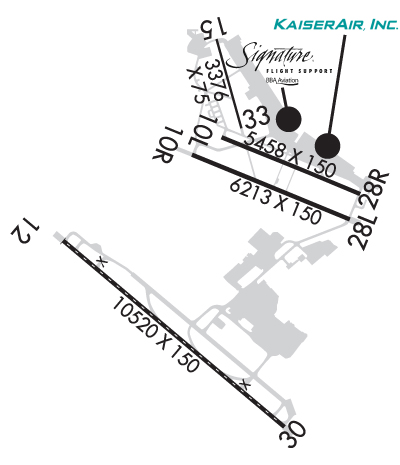
These numbers are Advisory and are not limits.   The Airport Manager should have more accurate Weight Limits
Approach Charts
Approaches    
Current Weather/Notams
7200' Runway  200-1/2 ILS
Customs Information Send updates to Support@FltPlan.com
Phone 510-271-8900
Fax 510-273-4068

Comments Weekdays 0930-1700* Weekends 0800-1500 4 hr advance notice required *Maximum passengers per flight: 15 E-Mail Requests Preferred: oakprivateairops@cbp.dhs.gov *Call prior to 1700 on preceding weekday *Call prior to 1700 on preceding Friday for weekend service and Holidays. Dial extension 2001 for agent.
Database effective 04/18/2024
Airport Diagram of KOAK
Airport Diagram might not be current.

Facility Name: METRO OAKLAND INTL
City Name: OAKLAND
County: ALAMEDA
State abbrev: CA
State Name: CALIFORNIA
   
Ownership: PUBLICLY OWNED
Use: OPEN TO THE PUBLIC
Owner's Name: PORT OF OAKLAND
Address: 530 WATER ST.
 OAKLAND, CA 94607
Owner's Phone: 510-563-3300
  
Manager's Name: MATT DAVIS; OPERATIONS - DARRON EVANS, OPNS SUPERINTENDENT (510)563-6432, CELL: (510) 715-6286 24HR OPERATIONS (510) 563-3361.
Address: METROPOLITAN OAKLAND INTL ARPT
 OAKLAND, CA 94621
Phone: 510-563-6436
   
FAA Region: WESTERN-PACIFIC
FAA Field Office: SFO
Photo courtesy of Jim Anderson and Aaron Clark


Click here for full scale & interactive Sectional view of KOAK


Sunrise / Sunset times for METRO OAKLAND INTL

DateSunriseSunset
04/17/24 Wednesday6:3019:47
04/18/24 Thursday6:2919:48
04/19/24 Friday6:2719:49
04/20/24 Saturday6:2619:50
04/21/24 Sunday6:2519:51
04/22/24 Monday6:2319:52
04/23/24 Tuesday6:2219:53
04/24/24 Wednesday6:2119:54
04/25/24 Thursday6:1919:55
04/26/24 Friday6:1819:55
04/27/24 Saturday6:1719:56
04/28/24 Sunday6:1619:57
04/29/24 Monday6:1519:58
04/30/24 Tuesday6:1319:59

Airport Facilities

Airport Attendance ScheduleCONTINUOUS
Airport Status OPERATIONAL (This Status can change at any time - please check NOTAMS)
Airport Lighting Schedule
Airport Storage AvailableTie Downs
Extra Services AvailableAir Freight, Avionics, Cargo Handling, Charter, Flight Instruction, Aircraft Rental, Aircraft Sales
Wind IndicatorYES - (lighted)
Control TowerYES
CTAF Frequency
Unicom Frequency122.950
Rotating Beacon ColorWG
Segmented CircleNO
Landing FeeYES; LDG FEE IN EFCT 24 HRS/DAY, CTC AIRFIELD OPS (510) 563-3361.

Airport Inspection Data

Airport InspectedFEDERAL - performed by FAA AIRPORTS FIELD PERSONNEL
Inspection Date06/29/2023

Airport Services

Type of Fuel AvailableGrade 100LL, JET A (freeze point -40C)
Airframe Repair ServiceMAJOR
Power Plant Repair ServiceMAJOR

Geographic Data

LatitudeN3743.3
LongitudeW12213.3 (ESTIMATED)
Arpt Elevation9ft (SURVEYED)
Magnetic Variation14E
4 miles Sof OAKLAND
Traffic Pattern AltitudeTFC PAT ALT RWY 28L 606' MSL; RWY 28R 1006' MSL.
Sectional ChartSAN FRANCISCO

Aircraft Data

Operations (Reported)YearlyAvg. Daily
General Aviation Transient 3114785
General Aviation Local 38637106
Air Taxi 2964481
Commerical 127920350
Commuter 00
Military 8402
Aircraft based on Field
General Aviation Singles 162
General Aviation Multi 24
Jet Aircraft 71
General Aviation Helicopters 7
Military Aircraft 0
Gliders 0
Ultralights 0

FAA Services

FSS on field NO
FSS tie-in OAKLAND
FSS Phone 1-800-WX-BRIEF
Who issues Notams OAK
Notam D service at airport YES
ARTCC Name OAKLAND

Federal Status

Airport CertificationAIRPORT RECEIVING SCHEDULED AIR CARRIER SERVICE FROM CARRIERS CERTIFICATED BY THE CIVIL AERONAUTICS BOARD; RWY 15/33 NOT AVBL FOR SKED ACR OPNS WITH MORE THAN 9 PSGR SEATS OR UNSKED ACR AT LEAST 31 PSGR SEATS.
Aircraft Rescue & Firefighting IndexAIRPORT HAS A CERTIFICATE UNDER CFR PART 139
Airport of EntryNo
Custom Landing RightsYES
Joint Civil/MilitaryNo
Military Landing rightsYES

Federal Agreements

NATIONAL PLAN OF INTEGRATED AIRPORT SYSTEMS (NPIAS)
GRANT AGREEMENTS UNDER FAAP/ADAP/AIP
SURPLUS PROPERTY AGREEMENT UNDER PUBLIC LAW 289
ASSURANCES PURSUANT TO TITLE VI, CIVIL RIGHTS ACT OF 1964

Remarks

BIRDS ON & INVOF ARPT.
RWYS 30, 28R AND RWY 28L DIST RMNG SIGNS L SIDE.
FOR NOISE ABATEMENT INFO CTC NOISE ABATEMENT OFC AT (510) 563-6463.
RWY 15/33 CLSD TO ACR ACFT.
PREFERENTIAL RWY USE PROGRAM IN EFFECT 2200-0600. NORTH FLD PREF ARR RWY 28L, NORTH FLD PREF DEP RWYS 10R OR 28R. IF THESE RWYS UNACCEPTABLE FOR SAFETY OR ATC INSTRN THEN RWY 12/30 MUST BE USED.
24 HR NOISE ABATEMENT PROCEDURE - TBJT AND TURBOFAN PWRD ACFT, TURBOROPS OVER 17,000 LBS, FOUR-ENGINE RECIPROCATING PWRD ACFT, AND SURPLUS MIL ACFT OVER 12,500 POUNDS SHOULD NOT DEP RWYS 28L & 28R OR LAND ON RWYS 10R & 10L.
TWY A, E, G, H BTN RWY 28R AND TWY C MAX ACFT WT 150,000 LBS.
TWY G & H BTN RWY 28L & 28R: MAX ACFT WT 12,500 LBS.
TWY P MAX ACFT WT 116,000 LBS SINGLE; 190,000 LBS DUAL; 305,000 LBS DUAL TANDEM; 735,000 LBS DOUBLE DUAL TANDEM.
TWY C BTN RWY 28R & TWY G AND TWYS B, J, AND D MAX ACFT WT 861,000 LBS.
TWY C BTN TWY G & J MAX ACFT WEIGHT 90,000 LBS SINGLE; 144,000 LBS DUAL; 257,000 LBS TANDEM.
TWY C BTN TWY J & F MAX ACFT WEIGHT 76,000 LBS SINGLE; 115,000 LBS DUAL; 257,000 LBS TANDEM (DUAL TANDEM NA).
TWY K BTN TWY D & INT TWYS F, L, K MAX ACFT WEIGHT 56,000 LBS SINGLE; 70,000 LBS DUAL; 130,000 LBS TANDEM.
TWY K BTN TWY J AND INT TWYS F, L, K MAX ACFT WT 33000 LBS SINGLE; 45000 LBS DUAL; TANDEM NA.
400 FT BY 220 FT BLAST PAD RWY 12 AND RWY 30.
UNDERLIES CLASS B ASP, BE AWARE OF SPEEDS ON ARR AND DEP.
NOISE ABATEMENT PROCS N/A IN EMERGS OR WHENEVER RWY 12/30 IS CLSD DUE TO MAINT, SAFETY, WINDS OR WX.
ACFT WITH EXPERIMENTAL OR LTD CERTIF HAVING OVER 1000 HORSEPOWER OR 4000 LBS ARE RSTRD TO RWY 12/30.
100 FT LGTD MICROWAVE ANT TWR LCTD 1320 FT WSW OF OAK VORTAC; S OF UPWIND END OF RWY 28L.
RWY 10L/ 28RPCR VALUE: 1266/F/B/X/T
RWY 10R/ 28LPCR VALUE: 934/F/B/X/T
RWY 12/3 0 PCR VALUE: 1295/F/B/X/T
Airport Communications & Frequencies:
ATIS Frequencies:   Hours(local) of Operation: CONTINUOUS
133.775
OAKLAND Tower Frequencies:   Hours(local) of operation: CONTINUOUS   
118.3 ;RWY 10L/28R, 10R/28L, 15/33
124.9
127.2 ;RWY 12/30
256.9 ;RWY 12/30
291.65 ;RWY 10L/28R, 10R/28L, 15/33
OAKLAND Ground Frequencies:
121.75 ;RWY 12/30
121.9 ;RWY 10L/28R, 10R/28L, 15/33
Clearance Delivery Frequencies:
121.1
Emergency Frequencies:
243.0
Unicom Frequency:
122.950
Remarks
  • MASTER (NCT) ARPT PRVDS CLASS B SVC FOR SAN FRANCISCO INTL.
  • FREQ 121.5/243.0 NOT AVBL AT ATCT.
  • NORCAL Primary Approach Frequencies:  
    125.35 EAST
    125.35 RWY 28L/R
    128.325
    135.1 WEST
    263.15
    307.2 WEST
    310.8 SOUTH
    354.1 RWY 28L/R
    Part-time Approach Frequencies:  
    133.95
    134.5
    317.6
    338.2
    NORCAL Primary Departure Frequencies:  
    120.9 NW
    135.1 WEST
    307.2 WEST
    323.2 NW
    354.1 RWY 28
    Class C Frequencies:
    120.9 NW
    125.35 EAST
    127.0 NORTH
    133.95 SOUTH
    135.1 WEST
    298.95 NORTH
    307.2 WEST
    317.6 SOUTH
    323.2 NW
    354.1 EAST
    Runway Identifications
    Runway Identification: 10L/28R
    Length: 5457 ft
    Width: 150 ft
    Surface: ASPHALT-GOOD CONDITION
    Edge lights: High Intensity

    Treatment: GROOVED

     Runway: 10L   Runway: 28R
    Mag heading: 98°Mag heading: 278°
    Rwy Slope: .01% UpRwy Slope: -.01% Down
    Approach: Approach: ILS
    Pattern: Left TrafficPattern: Right Traffic
    Markings: NONPRECISION INSTRUMENTMarkings: PRECISION INSTRUMENT
    Marking Condition: GOODMarking Condition: GOOD
    Arresting Dev: Arresting Dev:
    Lat & Long: N3743.8  W12213.3Lat. & Long.: N3743.5  W12212.3
    Elev: 5.5 ft. MSLElev: 5.8 ft. MSL
    TCH: 50 ft. AGLTCH: 51 ft. AGL
    Visual Glide Path: 3.00 degreesVisual Glide Path: 3.00 degrees
    Displaced Threshold: NoDisplaced Threshold: No
    Touchdown Zone: YESTouchdown Zone: YES
    Touchdown Elev.: 6.3 feetTouchdown Elev.: 6.8 feet
    Visual Glide Slope: 4-Light PAPI on RIGHT side of RunwayVisual Glide Slope: 4-Light PAPI on LEFT side of Runway
    RVR Equipment: ROLLOUTRVR Equipment: TOUCHDOWN
    RVV Equipment: NORVV Equipment: YES
    Approach Lights: Approach Lights: MALSR - 1,400 foot medium intensity approach lighting system with runway alignment indicator lights
    REIL: NOREIL: NO
    Centerline Lights: NOCenterline Lights: NO
    Touchdown lights: NOTouchdown lights: NO
    Runway Category: Runway with a Non-precision Approach having visibility minimums greater than 3/4 mileRunway Category: Precision Instrument Runway
    Declared Distances: TORA:5457' TODA:5457' ASDA:5336' LDA:5336'Declared Distances: TORA:5457' TODA:5457' ASDA:5457' LDA:5457'
    Obstructions: Obstructions: BLDG
    Marked: Marked: LIGHTED
    Clearance slope: 50:1Clearance slope: 30:1
    Obstruction height: Obstruction height: 11 feet AGL
    Dist. from runway: Dist. from runway: 530 feet
    Centerline offset: Centerline offset: 480 feet right of centerline
    Comments: Comments:
    Runway Identification: 10R/28L
    Length: 6213 ft
    Width: 150 ft
    Surface: ASPHALT-GOOD CONDITION
    Edge lights: High Intensity

    Treatment: GROOVED

     Runway: 10R   Runway: 28L
    Mag heading: 98°Mag heading: 278°
    Rwy Slope: .00% UpRwy Slope: .00% Down
    Approach: Approach:
    Pattern: Left TrafficPattern: Left Traffic
    Markings: NONPRECISION INSTRUMENTMarkings: PRECISION INSTRUMENT
    Marking Condition: GOODMarking Condition: GOOD
    Arresting Dev: Arresting Dev: EMAS; ENGINEERED MATERIALS ARRESTING SYSTEM (EMAS) 162 FT IN LENGTH BY 154 FT IN WIDTH LCTD AT THE DER 28L.
    Lat & Long: N3743.7  W12213.6Lat. & Long.: N3743.3  W12212.4
    Elev: 8.0 ft. MSLElev: 8.2 ft. MSL
    TCH: 50 ft. AGLTCH: 50 ft. AGL
    Visual Glide Path: 3.00 degreesVisual Glide Path: 3.00 degrees
    Displaced Threshold: NoDisplaced Threshold: No
    Touchdown Zone: YESTouchdown Zone: YES
    Touchdown Elev.: 8.9 feetTouchdown Elev.: 8.6 feet
    Visual Glide Slope: 4-Light PAPI on LEFT side of RunwayVisual Glide Slope: 4-Light PAPI on RIGHT side of Runway
    RVR Equipment: RVR Equipment:
    RVV Equipment: NORVV Equipment: YES
    Approach Lights: Approach Lights:
    REIL: YESREIL: NO
    Centerline Lights: NOCenterline Lights: NO
    Touchdown lights: NOTouchdown lights: NO
    Runway Category: Runway with a Non-precision Approach having visibility minimums greater than 3/4 mileRunway Category: D
    Declared Distances: TORA:6213' TODA:6213' ASDA:6213' LDA:6213'Declared Distances: TORA:6213' TODA:6213' ASDA:6213' LDA:6213'
    Runway Identification: 12/30
    Length: 10520 ft
    Width: 150 ft
    Surface: ASPHALT-GOOD CONDITION
    Edge lights: High Intensity

    Treatment: GROOVED

     Runway: 12   Runway: 30
    Mag heading: 116°Mag heading: 296°
    Rwy Slope: .01% UpRwy Slope: -.01% Down
    Approach: ILSApproach: ILS/DME
    Pattern: Right TrafficPattern: Left Traffic
    Markings: PRECISION INSTRUMENTMarkings: PRECISION INSTRUMENT
    Marking Condition: GOODMarking Condition: GOOD
    Arresting Dev: Arresting Dev:
    Lat & Long: N3743.2  W12214.5Lat. & Long.: N3742.1  W12212.9
    Elev: 8.3 ft. MSLElev: 9.0 ft. MSL
    TCH: 70 ft. AGLTCH: 71 ft. AGL
    Visual Glide Path: 2.75 degreesVisual Glide Path: 3.00 degrees
    Displaced Threshold: NoDisplaced Threshold: 114 feet
    Touchdown Zone: YESTouchdown Zone: YES
    Touchdown Elev.: 8.6 feetTouchdown Elev.: 9.0 feet
    Visual Glide Slope: 4-Light PAPI on RIGHT side of RunwayVisual Glide Slope: 4-Light PAPI on LEFT side of Runway
    RVR Equipment: TOUCHDOWN-MIDFIELD-ROLLOUTRVR Equipment: TOUCHDOWN-MIDFIELD-ROLLOUT
    RVV Equipment: NORVV Equipment: NO
    Approach Lights: MALSR - 1,400 foot medium intensity approach lighting system with runway alignment indicator lightsApproach Lights: ALSF2 - standard 2,400 foot high intensity approach lighting system with sequenced flashers, Category II or III
    REIL: NOREIL: NO
    Centerline Lights: YESCenterline Lights: YES
    Touchdown lights: NOTouchdown lights: YES
    Runway Category: Precision Instrument RunwayRunway Category: Precision Instrument Runway
    Declared Distances: TORA:10000' TODA:10000' ASDA:10000' LDA:10000'Declared Distances: TORA:10000' TODA:10000' ASDA:10000' LDA:10000'
    Runway Identification: 15/33
    Length: 3376 ft
    Width: 75 ft
    Surface: ASPHALT-GOOD CONDITION
    Edge lights: Medium Intensity

    Treatment: NONE

     Runway: 15   Runway: 33
    Mag heading: 150°Mag heading: 330°
    Rwy Slope: .07% UpRwy Slope: -.07% Down
    Approach: Approach:
    Pattern: Left TrafficPattern: Right Traffic
    Markings: BASICMarkings: BASIC
    Marking Condition: GOODMarking Condition: GOOD
    Arresting Dev: Arresting Dev:
    Lat & Long: N3744.4  W12213.4Lat. & Long.: N3743.9  W12213.2
    Elev: 1.4 ft. MSLElev: 3.9 ft. MSL
    TCH: TCH:
    Visual Glide Path: Visual Glide Path:
    Displaced Threshold: NoDisplaced Threshold: No
    Touchdown Zone: YESTouchdown Zone: YES
    Touchdown Elev.: 4.6 feetTouchdown Elev.: 4.6 feet
    Visual Glide Slope: Visual Glide Slope:
    RVR Equipment: RVR Equipment:
    RVV Equipment: NORVV Equipment: NO
    Approach Lights: Approach Lights:
    REIL: NOREIL: NO
    Centerline Lights: NOCenterline Lights: NO
    Touchdown lights: NOTouchdown lights: NO
    Runway Category: Runway with a Visual ApproachRunway Category: Runway with a Visual Approach
    Declared Distances: Declared Distances:
    C:217/P: