| |||||||||||||||||||||||||||||||||||||||||||||||||||||||||||||
| |||||||||||||||||||||||||||||||||||||||||||||||||||||||||||||
| |||||||||||||||||||||||||||||||||||||||||||||||||||||||||||||
| Rwy | Rwy | |||||||
| 5000x75 | 5000' | 5000x75 | 5000' | |||||
| Runway ID | Single Wheel | Double Wheel | Double Tandem Wheel | Dual Double Wheel |
| 02/20 | N/A | N/A | N/A | N/A |
| These numbers are Advisory and are not limits. The Airport Manager should have more accurate Weight Limits | ||||
| FltPlan does not have IFR approach charts available for KO89. |
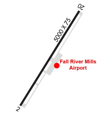 Airport Diagram might not be current. | |
| Facility Name: | FALL RIVER MILLS |
| City Name: | FALL RIVER MILLS |
| County: | SHASTA |
| State abbrev: | CA |
| State Name: | CALIFORNIA |
| Ownership: | PUBLICLY OWNED |
| Use: | OPEN TO THE PUBLIC |
| Owner's Name: | COUNTY OF SHASTA |
| Address: | 1855 PLACER STREET |
| REDDING, CA 96001 | |
| Owner's Phone: | 530-225-5661 |
| Manager's Name: | SHAWN ANKENY; SANKENY@CO.SHASTA.CA.US. |
| Address: | 1855 PLACER STREET |
| REDDING, CA 96001 | |
| Phone: | 530-245-6810 |
| FAA Region: | WESTERN-PACIFIC |
| FAA Field Office: | SFO |
| Date | Sunrise | Sunset |
|---|---|---|
| 04/17/24 Wednesday | 6:22 | 19:49 |
| 04/18/24 Thursday | 6:21 | 19:50 |
| 04/19/24 Friday | 6:19 | 19:51 |
| 04/20/24 Saturday | 6:18 | 19:52 |
| 04/21/24 Sunday | 6:16 | 19:53 |
| 04/22/24 Monday | 6:15 | 19:54 |
| 04/23/24 Tuesday | 6:13 | 19:55 |
| 04/24/24 Wednesday | 6:12 | 19:56 |
| 04/25/24 Thursday | 6:11 | 19:57 |
| 04/26/24 Friday | 6:09 | 19:58 |
| 04/27/24 Saturday | 6:08 | 19:59 |
| 04/28/24 Sunday | 6:07 | 20:00 |
| 04/29/24 Monday | 6:05 | 20:01 |
| 04/30/24 Tuesday | 6:04 | 20:02 |
| Airport Attendance Schedule | UNATNND |
| Airport Status | OPERATIONAL (This Status can change at any time - please check NOTAMS) |
| Airport Lighting Schedule | ACTVT MIRL RY 02/20 - CTAF. |
| Airport Storage Available | Tie Downs |
| Extra Services Available | NONE |
| Wind Indicator | YES - (lighted) |
| Control Tower | NO |
| CTAF Frequency | 122.800 |
| Unicom Frequency | 122.800 |
| Rotating Beacon Color | WG |
| Segmented Circle | YES |
| Landing Fee | NO |
| Airport Inspected | STATE - performed by STATE AERONAUTICAL PERSONNEL |
| Inspection Date | 05/24/2023 |
| Type of Fuel Available | None |
| Airframe Repair Service | NONE |
| Power Plant Repair Service | NONE |
| Latitude | N4101.0 |
| Longitude | W12126.1 (ESTIMATED) |
| Arpt Elevation | 3328ft (ESTIMATED) |
| Magnetic Variation | 17E |
| 1 miles N | of FALL RIVER MILLS |
| Traffic Pattern Altitude | 800 |
| Sectional Chart | KLAMATH FALLS |
| Operations (Reported) | Yearly | Avg. Daily |
|---|---|---|
| General Aviation Transient | 2500 | 7 |
| General Aviation Local | 2500 | 7 |
| Air Taxi | 0 | 0 |
| Commerical | 0 | 0 |
| Commuter | 0 | 0 |
| Military | 0 | 0 |
| Aircraft based on Field | |
|---|---|
| General Aviation Singles | 9 |
| General Aviation Multi | 0 |
| Jet Aircraft | 0 |
| General Aviation Helicopters | 0 |
| Military Aircraft | 0 |
| Gliders | 0 |
| Ultralights | 0 |
| FSS on field | NO |
| FSS tie-in | RANCHO MURIETA |
| FSS Phone | 1-800-WX-BRIEF |
| Who issues Notams | RIU |
| Notam D service at airport | YES |
| ARTCC Name | OAKLAND |
| Airport Certification | |
| Aircraft Rescue & Firefighting Index | None |
| Airport of Entry | No |
| Custom Landing Rights | No |
| Joint Civil/Military | No |
| Military Landing rights | No |
| NATIONAL PLAN OF INTEGRATED AIRPORT SYSTEMS (NPIAS) |
| GRANT AGREEMENT HAS EXPIRED; HOWEVER, AGREEMENT REMAINS IN EFFECT FOR THIS FACILITY AS LONG AS IT IS PUBLIC USE. |
| CROP DUSTERS WORKING INVOF ARPT FEB-OCT. |
| ARPT CLSD PERIODICALLY WINTER MONTHS DUE TO SNOW, CALL AMGR (530) 225-5661 FOR CURRENT CONDITIONS. |
| FOR CD CTC OAKLAND ARTCC AT 510-745-3380. |
| RWY 02/2 0 GROSS WEIGHT STRENGTH PRVDD BY ARPT MANAGEMENT 12500 LBS. |
| Runway: 02 | Runway: 20 | ||
| Mag heading: | 17° | Mag heading: | 197° |
| Rwy Slope: | -.11% Down | Rwy Slope: | .11% Up |
| Approach: | Approach: | ||
| Pattern: | Left Traffic | Pattern: | Left Traffic |
| Markings: | BASIC | Markings: | BASIC |
| Marking Condition: | GOOD | Marking Condition: | GOOD |
| Arresting Dev: | Arresting Dev: | ||
| Lat & Long: | N4100.7 W12126.4 | Lat. & Long.: | N4101.4 W12125.8 |
| Elev: | 3328.0 ft. MSL | Elev: | 3322.7 ft. MSL |
| TCH: | TCH: | ||
| Visual Glide Path: | Visual Glide Path: | ||
| Displaced Threshold: | No | Displaced Threshold: | No |
| Touchdown Zone: | YES | Touchdown Zone: | YES |
| Touchdown Elev.: | 3328.0 feet | Touchdown Elev.: | 3327.3 feet |
| Visual Glide Slope: | Visual Glide Slope: | ||
| RVR Equipment: | RVR Equipment: | ||
| RVV Equipment: | NO | RVV Equipment: | NO |
| Approach Lights: | Approach Lights: | ||
| REIL: | NO | REIL: | NO |
| Centerline Lights: | NO | Centerline Lights: | NO |
| Touchdown lights: | NO | Touchdown lights: | NO |
| Runway Category: | Runway with a Visual Approach | Runway Category: | Runway with a Visual Approach |
| Declared Distances: | Declared Distances: |