
| ||||||||||||||||||||||||||||||||
| ||||||||||||||||||||||||||||||||
| ||||||||||||||||||||||||||||||||
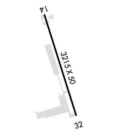
| Rwy | Rwy | |||||||
| 3215x50 | 3015' | 3215x50 | 3015' | |||||
| Runway ID | Single Wheel | Double Wheel | Double Tandem Wheel | Dual Double Wheel |
| 14/32 | 10,000 | N/A | N/A | N/A |
| These numbers are Advisory and are not limits. The Airport Manager should have more accurate Weight Limits | ||||
| FltPlan does not have IFR approach charts available for KO86. |
 Airport Diagram might not be current. | |
| Facility Name: | TRINITY CENTER |
| City Name: | TRINITY CENTER |
| County: | TRINITY |
| State abbrev: | CA |
| State Name: | CALIFORNIA |
| Ownership: | PUBLICLY OWNED |
| Use: | OPEN TO THE PUBLIC |
| Owner's Name: | TRINITY COUNTY |
| Address: | PO BOX 2490 |
| WEAVERVILLE, CA 96093-0476 | |
| Owner's Phone: | 530-623-1365 |
| Manager's Name: | PANOS KOKKAS; DIRECTOR OF TRANSPORTATION |
| Address: | PO BOX 2490 |
| WEAVERVILLE, CA 96093-2490 | |
| Phone: | 530-623-1365 |
| FAA Region: | WESTERN-PACIFIC |
| FAA Field Office: | SFO |
| Date | Sunrise | Sunset |
|---|---|---|
| 04/24/24 Wednesday | 6:17 | 20:01 |
| 04/25/24 Thursday | 6:16 | 20:02 |
| 04/26/24 Friday | 6:14 | 20:03 |
| 04/27/24 Saturday | 6:13 | 20:04 |
| 04/28/24 Sunday | 6:12 | 20:05 |
| 04/29/24 Monday | 6:10 | 20:06 |
| 04/30/24 Tuesday | 6:09 | 20:07 |
| 05/01/24 Wednesday | 6:08 | 20:08 |
| 05/02/24 Thursday | 6:06 | 20:09 |
| 05/03/24 Friday | 6:05 | 20:10 |
| 05/04/24 Saturday | 6:04 | 20:12 |
| 05/05/24 Sunday | 6:03 | 20:13 |
| 05/06/24 Monday | 6:02 | 20:14 |
| 05/07/24 Tuesday | 6:00 | 20:15 |
| Airport Attendance Schedule | UNATTENDED |
| Airport Status | OPERATIONAL (This Status can change at any time - please check NOTAMS) |
| Airport Lighting Schedule | |
| Airport Storage Available | Tie Downs |
| Extra Services Available | NONE |
| Wind Indicator | YES - (unlit) |
| Control Tower | NO |
| CTAF Frequency | 122.900 |
| Unicom Frequency | |
| Rotating Beacon Color | |
| Segmented Circle | YES |
| Landing Fee | NO |
| Airport Inspected | STATE - performed by STATE AERONAUTICAL PERSONNEL |
| Inspection Date | 09/19/2023 |
| Type of Fuel Available | None |
| Airframe Repair Service | None |
| Power Plant Repair Service | None |
| Latitude | N4059.0 |
| Longitude | W12241.6 (ESTIMATED) |
| Arpt Elevation | 2390ft (SURVEYED) |
| Magnetic Variation | 17E |
| 0 miles E | of TRINITY CENTER |
| Traffic Pattern Altitude | 800 |
| Sectional Chart | KLAMATH FALLS |
| Operations (Reported) | Yearly | Avg. Daily |
|---|---|---|
| General Aviation Transient | 4000 | 11 |
| General Aviation Local | 4500 | 12 |
| Air Taxi | 0 | 0 |
| Commerical | 0 | 0 |
| Commuter | 0 | 0 |
| Military | 0 | 0 |
| Aircraft based on Field | |
|---|---|
| General Aviation Singles | 10 |
| General Aviation Multi | 1 |
| Jet Aircraft | 0 |
| General Aviation Helicopters | 1 |
| Military Aircraft | 0 |
| Gliders | 0 |
| Ultralights | 0 |
| FSS on field | NO |
| FSS tie-in | RANCHO MURIETA |
| FSS Phone | 1-800-WX-BRIEF |
| Who issues Notams | RIU |
| Notam D service at airport | YES |
| ARTCC Name | OAKLAND |
| Airport Certification | |
| Aircraft Rescue & Firefighting Index | None |
| Airport of Entry | No |
| Custom Landing Rights | No |
| Joint Civil/Military | No |
| Military Landing rights | No |
| NATIONAL PLAN OF INTEGRATED AIRPORT SYSTEMS (NPIAS) |
| GRANT AGREEMENT HAS EXPIRED; HOWEVER, AGREEMENT REMAINS IN EFFECT FOR THIS FACILITY AS LONG AS IT IS PUBLIC USE. |
| HIGH TERRAIN ALL QUADRANTS. |
| GEESE ON AND IN THE VICINITY OF ARPT. |
| FOR CD CTC OAKLAND ARTCC AT 510-745-3380. |
| ARPT CLSD NIGHTS. |
| TREES/HOMES WEST SIDE OF APRT. |
| CALM WIND RY 14. |
| NOISE ABATEMENT PROCEDURES IN EFFECT W & NW OF ARPT. |
| INTERMITTENTLY CLOSED WINTERS DUE TO SNOW. CTC COUNTY TRANSPORTATION OFFICE FOR INFO 530-623-1365. |
| BE ALERT TO DEER ON RY. |
| Runway: 14 | Runway: 32 | ||
| Mag heading: | N/A | Mag heading: | N/A |
| Approach: | Approach: | ||
| Pattern: | Left Traffic | Pattern: | Right Traffic |
| Markings: | BASIC | Markings: | BASIC |
| Marking Condition: | GOOD | Marking Condition: | GOOD |
| Arresting Dev: | Arresting Dev: | ||
| Lat & Long: | N4059.2 W12241.7 | Lat. & Long.: | N4058.7 W12241.5 |
| Elev: | N/A | Elev: | N/A |
| TCH: | TCH: | ||
| Visual Glide Path: | Visual Glide Path: | ||
| Displaced Threshold: | 200 feet | Displaced Threshold: | 200 feet |
| Touchdown Zone: | NO | Touchdown Zone: | NO |
| Touchdown Elev.: | Touchdown Elev.: | ||
| Visual Glide Slope: | Visual Glide Slope: | ||
| RVR Equipment: | RVR Equipment: | ||
| RVV Equipment: | NO | RVV Equipment: | NO |
| Approach Lights: | Approach Lights: | ||
| REIL: | NO | REIL: | NO |
| Centerline Lights: | NO | Centerline Lights: | NO |
| Touchdown lights: | NO | Touchdown lights: | NO |
| Runway Category: | Runway with a Visual Approach | Runway Category: | Runway with a Visual Approach |
| Declared Distances: | Declared Distances: | ||
| Comments: | DIRT ROAD AND 4 FT FENCE 120 FT FM APCH END RWY 14. | Comments: |
