Click here for more info on on SMS!

KO79

SIERRAVILLE DEARWATER
SIERRAVILLE
CA
Time Zone: Pacific
Lat: N 3934.9
Long: W 12021.2
Elev: 4984
Var: -16
Longest Runway: 3260
CTAF: 122.9

FBO & Flight Services info for KO79

FBOs: Update your Fuel Prices

AIRPORT MANAGERPh: 530-289-3201
-
Freq: 122.9
Service
Jet
100LL
SAF
MoGas
Fuel Avail: NO FUEL AVAILABLE
Full        Last Update: 04/24/2024 06:02:16

Self        
If you are an FBO, call 1-203-262-1700 to update your info or email: FltPlan.Advertising@garmin.com
Advertise your FBO on FltPlan.com

Runway & Approach Info for KO79
Rwy
Length
Land Dist**
Approach*
  Rwy
Length
Land Dist**
Approach*
03
3260x50  3260'          
 
  
21
  3260x50  3067'          
 
 * only ILS, LOC, LDA, and SDF approaches to a specific runway are shown
** For any Declared Landing Distance Available, please see A/FD or Approach plates
Runway Weight Capability (lbs.) Help
Runway IDSingle WheelDouble WheelDouble Tandem WheelDual Double Wheel
03/2112,000N/AN/AN/A
These numbers are Advisory and are not limits.   The Airport Manager should have more accurate Weight Limits
Approach Charts
FltPlan does not have IFR approach charts available for KO79.
Current Weather/Notams
Customs Information Send updates to Support@FltPlan.com
Customs Not Available
Database effective 05/16/2024
Airport Diagram of KO79
Airport Diagram might not be current.

Facility Name: SIERRAVILLE DEARWATER
City Name: SIERRAVILLE
County: SIERRA
State abbrev: CA
State Name: CALIFORNIA
   
Ownership: PUBLICLY OWNED
Use: OPEN TO THE PUBLIC
Owner's Name: COUNTY OF SIERRA
Address: PO BOX 98
 DOWNIEVILLE, CA 95936
Owner's Phone: (530) 289-3201
  
Manager's Name: TIM BEALS; SIERRA COUNTY PUBLIC WORKS DIRECTOR.
Address: PO BOX 98
 DOWNIEVILLE, CA 95936
Phone: (530) 289-3201; SIERRA COUNTY PUBLIC WORKS DEPARTMENT, DOWNIEVILLE.
   
FAA Region: WESTERN-PACIFIC
FAA Field Office: SFO


Sunrise / Sunset times for SIERRAVILLE DEARWATER

DateSunriseSunset
04/23/24 Tuesday6:1219:48
04/24/24 Wednesday6:1019:49
04/25/24 Thursday6:0919:50
04/26/24 Friday6:0819:51
04/27/24 Saturday6:0619:52
04/28/24 Sunday6:0519:53
04/29/24 Monday6:0419:54
04/30/24 Tuesday6:0219:55
05/01/24 Wednesday6:0119:56
05/02/24 Thursday6:0019:57
05/03/24 Friday5:5919:58
05/04/24 Saturday5:5819:59
05/05/24 Sunday5:5720:00
05/06/24 Monday5:5520:01

Airport Facilities

Airport Attendance ScheduleUNATTENDED
Airport Status OPERATIONAL (This Status can change at any time - please check NOTAMS)
Airport Lighting Schedule
Airport Storage AvailableTie Downs
Extra Services AvailableNONE
Wind IndicatorYES - (unlit)
Control TowerNO
CTAF Frequency122.900
Unicom Frequency
Rotating Beacon Color
Segmented CircleYES
Landing FeeNO

Airport Inspection Data

Airport InspectedSTATE - performed by STATE AERONAUTICAL PERSONNEL
Inspection Date06/10/2022

Airport Services

Type of Fuel AvailableNone
Airframe Repair ServiceNONE
Power Plant Repair ServiceNONE

Geographic Data

LatitudeN3934.9
LongitudeW12021.2 (ESTIMATED)
Arpt Elevation4984ft (SURVEYED)
Magnetic Variation16E
1 miles SEof SIERRAVILLE
Traffic Pattern Altitude800
Sectional ChartSAN FRANCISCO

Aircraft Data

Operations (Reported)YearlyAvg. Daily
General Aviation Transient 12003
General Aviation Local 00
Air Taxi 00
Commerical 00
Commuter 00
Military 00
Aircraft based on Field
General Aviation Singles 0
General Aviation Multi 0
Jet Aircraft 0
General Aviation Helicopters 0
Military Aircraft 0
Gliders 0
Ultralights 0; ULTRALIGHT ACTIVITY ON & INVOF ARPT.

FAA Services

FSS on field NO
FSS tie-in RENO
FSS Phone 1-800-WX-BRIEF
Who issues Notams RNO
Notam D service at airport YES
ARTCC Name OAKLAND

Federal Status

Airport Certification
Aircraft Rescue & Firefighting IndexNone
Airport of EntryNo
Custom Landing RightsNo
Joint Civil/MilitaryNo
Military Landing rightsNo

Remarks

FOR CD CTC OAKLAND ARTCC AT 510-745-3380.
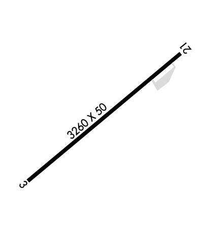
Runway Identifications
Runway Identification: 03/21
Length: 3260 ft
Width: 50 ft
Surface: ASPHALT-GOOD CONDITION
Edge lights:

Treatment: NONE

 Runway: 03   Runway: 21
Mag heading: N/AMag heading: N/A
Rwy Slope: -.98% DownRwy Slope: .98% Up
Approach: Approach:
Pattern: Left TrafficPattern: Right Traffic
Markings: BASICMarkings: BASIC
Marking Condition: GOODMarking Condition: GOOD
Arresting Dev: Arresting Dev:
Lat & Long: N3934.7  W12021.5Lat. & Long.: N3935.1  W12021.0
Elev: 4983.0 ft. MSLElev: 4951.0 ft. MSL
TCH: TCH:
Visual Glide Path: Visual Glide Path:
Displaced Threshold: NoDisplaced Threshold: 193 feet
Touchdown Zone: NOTouchdown Zone: NO
Touchdown Elev.: Touchdown Elev.:
Visual Glide Slope: Visual Glide Slope:
RVR Equipment: RVR Equipment:
RVV Equipment: NORVV Equipment: NO
Approach Lights: Approach Lights:
REIL: NOREIL: NO
Centerline Lights: NOCenterline Lights: NO
Touchdown lights: NOTouchdown lights: NO
Runway Category: Runway with a Visual ApproachRunway Category: Runway with a Visual Approach
Declared Distances: Declared Distances:
C:/P: