Click here for more info on on SMS!

KO61

CAMERON PARK
CAMERON PARK
CA
Time Zone: Pacific
Lat: N 3841.0
Long: W 12059.3
Elev: 1287
Var: -16
Longest Runway: 4051
CTAF: 123.05

FBO & Flight Services info for KO61

FBOs: Update your Fuel Prices

CAMERON PARK ARPTPh: 530-676-8316 Fax: N/A Freq: 123.05
Service
Jet
100LL
SAF
MoGas
Fuel Avail: 24/7 w/ Credit Card
Full        Last Update: 04/22/2024 12:09

Self  5.20    
 Address: 3374 MIRA LOMA DRIVE   CAMERON PARK, CA 95682
If you are an FBO, call 1-203-262-1700 to update your info or email: FltPlan.Advertising@garmin.com
Advertise your FBO on FltPlan.com

Runway & Approach Info for KO61
Rwy
Length
Land Dist**
Approach*
  Rwy
Length
Land Dist**
Approach*
13
4051x50  3858'          
 
  
31
  4051x50  2542'          
 
 * only ILS, LOC, LDA, and SDF approaches to a specific runway are shown
** For any Declared Landing Distance Available, please see A/FD or Approach plates
Runway Weight Capability (lbs.) Help
Runway IDSingle WheelDouble WheelDouble Tandem WheelDual Double Wheel
13/31N/AN/AN/AN/A
These numbers are Advisory and are not limits.   The Airport Manager should have more accurate Weight Limits
Approach Charts
FltPlan does not have IFR approach charts available for KO61.
Current Weather/Notams
Customs Information Send updates to Support@FltPlan.com
Customs Not Available
Database effective 05/16/2024
Airport Diagram of KO61
Airport Diagram might not be current.

Facility Name: CAMERON PARK
City Name: CAMERON PARK
County: EL DORADO
State abbrev: CA
State Name: CALIFORNIA
   
Ownership: PUBLICLY OWNED
Use: OPEN TO THE PUBLIC
Owner's Name: CAMERON PARK ARPT DISTRICT
Address: 3374 MIRA LOMA DRIVE
 CAMERON PARK, CA 95682
Owner's Phone: 530-676-8316
  
Manager's Name: DOMINIC COUTCHES
Address: 3374 MIRA LOMA DRIVE
 CAMERON PARK, CA 95682
Phone: 530-676-8316
   
FAA Region: WESTERN-PACIFIC
FAA Field Office: SFO


Sunrise / Sunset times for CAMERON PARK

DateSunriseSunset
04/25/24 Thursday6:1319:51
04/26/24 Friday6:1219:52
04/27/24 Saturday6:1019:53
04/28/24 Sunday6:0919:54
04/29/24 Monday6:0819:55
04/30/24 Tuesday6:0719:56
05/01/24 Wednesday6:0619:57
05/02/24 Thursday6:0419:58
05/03/24 Friday6:0319:59
05/04/24 Saturday6:0220:00
05/05/24 Sunday6:0120:01
05/06/24 Monday6:0020:02
05/07/24 Tuesday5:5920:03
05/08/24 Wednesday5:5820:04

Airport Facilities

Airport Attendance ScheduleMON-FRI 0800-1700
Airport Status OPERATIONAL (This Status can change at any time - please check NOTAMS)
Airport Lighting ScheduleACTVT MIRL RY 13/31 - CTAF.
Airport Storage AvailableTie Downs
Extra Services AvailableNONE
Wind IndicatorYES - (unlit)
Control TowerNO
CTAF Frequency123.050
Unicom Frequency123.050
Rotating Beacon Color
Segmented CircleYES
Landing FeeNO

Airport Inspection Data

Airport InspectedSTATE - performed by STATE AERONAUTICAL PERSONNEL
Inspection Date01/18/2024

Airport Services

Type of Fuel AvailableGrade 100LL; -10FUEL AVBL 24 HRS BY CREDIT CARD
Airframe Repair ServiceMAJOR
Power Plant Repair ServiceMAJOR

Geographic Data

LatitudeN3841.0
LongitudeW12059.3 (ESTIMATED)
Arpt Elevation1287ft (ESTIMATED)
Magnetic Variation16E
0 miles Nof CAMERON PARK
Traffic Pattern Altitude1014
Sectional ChartSAN FRANCISCO

Aircraft Data

Operations (Reported)YearlyAvg. Daily
General Aviation Transient 1000027
General Aviation Local 2527269
Air Taxi 7642
Commerical 00
Commuter 00
Military 00
Aircraft based on Field
General Aviation Singles 46
General Aviation Multi 4
Jet Aircraft 0
General Aviation Helicopters 0
Military Aircraft 0
Gliders 0
Ultralights 0

FAA Services

FSS on field NO
FSS tie-in RANCHO MURIETA
FSS Phone 1-800-WX-BRIEF
Who issues Notams RIU
Notam D service at airport YES
ARTCC Name OAKLAND

Federal Status

Airport Certification
Aircraft Rescue & Firefighting IndexNone
Airport of EntryNo
Custom Landing RightsNo
Joint Civil/MilitaryNo
Military Landing rightsNo

Federal Agreements

NATIONAL PLAN OF INTEGRATED AIRPORT SYSTEMS (NPIAS)

Remarks

THIS AIRPORT HAS BEEN SURVEYED BY THE NATIONAL GEODETIC SURVEY.
FOR CD CTC NORCAL APCH AT 916-361-6874.
DO NOT CONFUSE PARL RESIDENTIAL STREETS ON BOTH SIDES OF ARPT WITH THE RWY.
1597 FT HILL UNLGTD .5 NM SE OF ARPT.
FOR NOISE ABATEMENT PROCEDURES CALL AMGR (530) 676-8316
RY 13/31 WEST SIDE 60 FT GATES IN PERIMETER FENCING TO PROVIDE ACCESS TO RESIDENTIAL AREA FOR RESIDENTS AND INVITED GUESTS.
RY 13/31 RESTRICTED TO USE BY ACFT WITH LESS THAN A MAXIMUM CERTIFICATED GWT OF 12,500 LBS AND WINGSPAN LESS THAN 50 FT.
HELICOPTER PARKING NOT AUTHORIZED.
MIGRATORY GEESE IN VNCTY OF ARPT.
RWY 13/3 1 GROSS PAVEMENT STRENGTH ESTIMATED BY OWNER 12500 LBS.
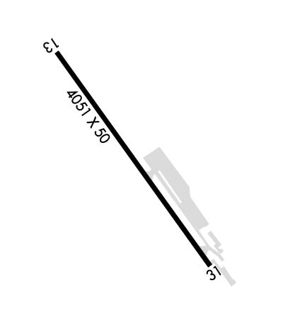
Runway Identifications
Runway Identification: 13/31
Length: 4051 ft
Width: 50 ft
Surface: ASPHALT-FAIR CONDITION
Edge lights: Medium Intensity

Treatment: NONE

 Runway: 13   Runway: 31
Mag heading: 128°Mag heading: 308°
Rwy Slope: -.49% DownRwy Slope: .49% Up
Approach: Approach:
Pattern: Left TrafficPattern: Left Traffic
Markings: BASICMarkings: BASIC
Marking Condition: GOODMarking Condition: GOOD
Arresting Dev: Arresting Dev:
Lat & Long: N3841.3  W12059.5Lat. & Long.: N3840.8  W12059.0
Elev: 1287.3 ft. MSLElev: 1267.3 ft. MSL
TCH: TCH: 18 ft. AGL
Visual Glide Path: Visual Glide Path: 6.00 degrees
Displaced Threshold: 193 feetDisplaced Threshold: 1509 feet
Touchdown Zone: YESTouchdown Zone: YES
Touchdown Elev.: 1282.9 feetTouchdown Elev.: 1282.9 feet
Visual Glide Slope: Visual Glide Slope: PULSATING/STEADY BURNING VASI ON LEFT SIDE OF RUNWAY
RVR Equipment: RVR Equipment:
RVV Equipment: NORVV Equipment: NO
Approach Lights: Approach Lights:
REIL: NOREIL: NO
Centerline Lights: NOCenterline Lights: NO
Touchdown lights: NOTouchdown lights: NO
Runway Category: Runway with a Visual ApproachRunway Category: Runway with a Visual Approach
Declared Distances: Declared Distances:
Obstructions: TREEObstructions: TREE
Marked: NOT Marked/LightedMarked: NOT Marked/Lighted
Clearance slope: 10:1; RWY 13 APCH RATIO 5:1 TO DSPLCD THLD OVER 65 FT TREE 350 FT FROM DSPLCD THRESHOLD.Clearance slope: 9:1; RY 31 +60 FT TREE 130 FT LEFT 250 FT FM EOR. APCH RATIO 29:1 TO DSPLCD THLD.
Obstruction height: 40 feet AGLObstruction height: 240 feet AGL
Dist. from runway: 410 feet; +4' TERRAIN 100' RIGHT.Dist. from runway: 2190 feet; TREE 1190' FROM THR.
Centerline offset: 125 left of centerlineCenterline offset: 300 feet right of centerline
Comments: +65 FT TREE, 150 FT FROM EOR, 125 FT LEFT OF RWY CENTERLINEComments: +8 FT GND 200 FT FM EOR.
C:2/P: