Click here for more info on on SMS!

KO60

CLOVERDALE MUNI
CLOVERDALE
CA
Time Zone: Pacific
Lat: N 3846.6
Long: W 12259.6
Elev: 276
Var: -16
Longest Runway: 2909
CTAF: 122.8

FBO & Flight Services info for KO60

FBOs: Update your Fuel Prices

CLOVERDALE MUNIPh: 707-694-9355 Fax: 707-894-5203 Freq: 122.8
Service
Jet
100LL
SAF
MoGas
Full        Last Update: 04/15/2024 17:31

Self  6.20    
 Address: 222 AIRPORT RD   CLOVERDALE, CA 95425
If you are an FBO, call 1-203-262-1700 to update your info or email: FltPlan.Advertising@garmin.com
Advertise your FBO on FltPlan.com

Runway & Approach Info for KO60
Rwy
Length
Land Dist**
Approach*
  Rwy
Length
Land Dist**
Approach*
14
2909x60  2909'          
 
  
32
  2909x60  2909'          
 
 * only ILS, LOC, LDA, and SDF approaches to a specific runway are shown
** For any Declared Landing Distance Available, please see A/FD or Approach plates
Runway Weight Capability (lbs.) Help
Runway IDSingle WheelDouble WheelDouble Tandem WheelDual Double Wheel
14/3212,000N/AN/AN/A
These numbers are Advisory and are not limits.   The Airport Manager should have more accurate Weight Limits
Approach Charts
Approaches    
Current Weather/Notams
Customs Information Send updates to Support@FltPlan.com
Customs Not Available
Database effective 04/18/2024
Airport Diagram of KO60
Airport Diagram might not be current.

Facility Name: CLOVERDALE MUNI
City Name: CLOVERDALE
County: SONOMA
State abbrev: CA
State Name: CALIFORNIA
   
Ownership: PUBLICLY OWNED
Use: OPEN TO THE PUBLIC
Owner's Name: CITY OF CLOVERDALE
Address: PO BOX 217
 CLOVERDALE, CA 95425
Owner's Phone: 707-894-2521
  
Manager's Name: MICHAEL MORRISSEY
Address: 124 N. CLOVERDALE BLVD.
 CLOVERDALE, CA 95425
Phone: 707-894-2150
   
FAA Region: WESTERN-PACIFIC
FAA Field Office: SFO


Sunrise / Sunset times for CLOVERDALE MUNI

DateSunriseSunset
04/19/24 Friday6:2919:54
04/20/24 Saturday6:2719:55
04/21/24 Sunday6:2619:56
04/22/24 Monday6:2519:57
04/23/24 Tuesday6:2319:57
04/24/24 Wednesday6:2219:58
04/25/24 Thursday6:2119:59
04/26/24 Friday6:1920:00
04/27/24 Saturday6:1820:01
04/28/24 Sunday6:1720:02
04/29/24 Monday6:1620:03
04/30/24 Tuesday6:1520:04
05/01/24 Wednesday6:1320:05
05/02/24 Thursday6:1220:06

Airport Facilities

Airport Attendance Schedule7 Days A Week 0800-1700
Airport Status OPERATIONAL (This Status can change at any time - please check NOTAMS)
Airport Lighting ScheduleACTVT PAPI RWY 14 AND MIRL RWY 14/32 - CTAF.
Airport Storage AvailableTie Downs
Extra Services AvailableFlight Instruction, Parachute Jumping, Aircraft Rental, Aircraft Sales
Wind IndicatorYES - (lighted)
Control TowerNO
CTAF Frequency122.800
Unicom Frequency122.800
Rotating Beacon Color
Segmented CircleYES
Landing FeeNO

Airport Inspection Data

Airport InspectedSTATE - performed by STATE AERONAUTICAL PERSONNEL
Inspection Date04/05/2023

Airport Services

Type of Fuel AvailableGrade 100LL; -10FUEL AVBL 24 HRS WITH CREDIT CARD.
Airframe Repair ServiceNone
Power Plant Repair ServiceNone

Geographic Data

LatitudeN3846.6
LongitudeW12259.6 (ESTIMATED)
Arpt Elevation275ft (SURVEYED)
Magnetic Variation16E
3 miles SEof CLOVERDALE
Traffic Pattern Altitude
Sectional ChartSAN FRANCISCO

Aircraft Data

Operations (Reported)YearlyAvg. Daily
General Aviation Transient 790022
General Aviation Local 30008
Air Taxi 00
Commerical 00
Commuter 00
Military 00
Aircraft based on Field
General Aviation Singles 14
General Aviation Multi 1
Jet Aircraft 0
General Aviation Helicopters 0
Military Aircraft 0
Gliders 1
Ultralights 0

FAA Services

FSS on field NO
FSS tie-in OAKLAND
FSS Phone 1-800-WX-BRIEF
Who issues Notams OAK
Notam D service at airport YES
ARTCC Name OAKLAND

Federal Status

Airport Certification
Aircraft Rescue & Firefighting IndexNone
Airport of EntryNo
Custom Landing RightsNo
Joint Civil/MilitaryNo
Military Landing rightsYES

Federal Agreements

NATIONAL PLAN OF INTEGRATED AIRPORT SYSTEMS (NPIAS)
GRANT AGREEMENTS UNDER FAAP/ADAP/AIP
ASSURANCES PURSUANT TO TITLE VI, CIVIL RIGHTS ACT OF 1964

Remarks

FOR CD CTC OAKLAND ARTCC AT 510-745-3380.
Airport Communications & Frequencies:
CTAF Frequency:
122.800
Unicom Frequency:
122.800
Remarks
  • APCH/DEP CTL SVC PRVDD BY OAKLAND ARTCC (ZOA) ON FREQ 127.8/353.5 (MOUNT TAMALPAIS RCAG).
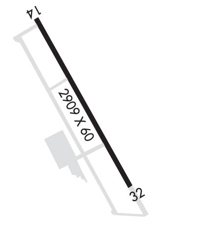
  • Runway Identifications
    Runway Identification: 14/32
    Length: 2909 ft
    Width: 60 ft
    Surface: ASPHALT-GOOD CONDITION
    Edge lights: Medium Intensity

    Treatment: NONE

     Runway: 14   Runway: 32
    Mag heading: 137°Mag heading: 317°
    Rwy Slope: -.08% DownRwy Slope: .08% Up
    Approach: Approach:
    Pattern: Left TrafficPattern: Right Traffic
    Markings: BASICMarkings: NONPRECISION INSTRUMENT
    Marking Condition: FAIRMarking Condition: FAIR
    Arresting Dev: Arresting Dev:
    Lat & Long: N3846.8  W12259.7Lat. & Long.: N3846.4  W12259.4
    Elev: 275.0 ft. MSLElev: 272.8 ft. MSL
    TCH: 40 ft. AGLTCH: 40 ft. AGL
    Visual Glide Path: 3.00 degreesVisual Glide Path: 3.50 degrees
    Displaced Threshold: NoDisplaced Threshold: No
    Touchdown Zone: YESTouchdown Zone: YES
    Touchdown Elev.: 275.9 feetTouchdown Elev.: 275.9 feet
    Visual Glide Slope: 2-Light PAPI on LEFT side of Runway; UNUSBL BYD 3.3 NM.Visual Glide Slope: 2-Light PAPI on LEFT side of Runway
    RVR Equipment: RVR Equipment:
    RVV Equipment: NORVV Equipment: NO
    Approach Lights: Approach Lights:
    REIL: YESREIL: YES
    Centerline Lights: NOCenterline Lights: NO
    Touchdown lights: NOTouchdown lights: NO
    Runway Category: Runway with a Visual ApproachRunway Category: Runway with a Non-precision Approach
    Declared Distances: Declared Distances:
    Obstructions: UnknownObstructions: BRUSH
    Marked: NOT Marked/LightedMarked: NOT Marked/Lighted
    Clearance slope: 50:1Clearance slope:
    Obstruction height: 0 feet AGLObstruction height: 15 feet AGL
    Dist. from runway: 0 feetDist. from runway: 200 feet
    Centerline offset: Centerline offset:
    Comments: Comments: RWY 32 +10 FT ROAD AT 0 FT & 105 FT L; +4 FT FENCE AT 0 FT & 125 FT L; +20 FT BRUSH AT 200 FT & 100 FT R.
    C:/P: