Approach Charts
| FltPlan does not have IFR approach charts available for KO59. |
Current Weather/Notams (Metars, TAFs, Notams, NWS Forecast, PIREPS, and nearby weather)
Customs Information Send updates to Support@FltPlan.com
Customs Not Available
Database effective 04/18/2024
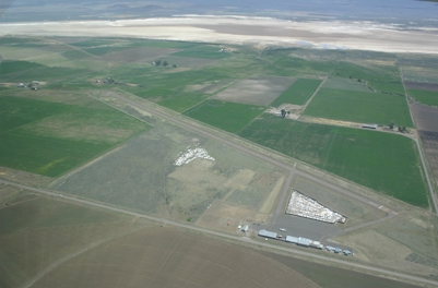
Airport Diagram might not be current.
|
| Facility Name: | CEDARVILLE |
| City Name: | CEDARVILLE |
| County: | MODOC |
| State abbrev: | CA |
| State Name: | CALIFORNIA |
| | |
| Ownership: | PUBLICLY OWNED |
| Use: | OPEN TO THE PUBLIC |
| Owner's Name: | COUNTY OF MODOC |
| Address: | 202 W 4TH ST |
| | ALTURAS, CA 96101 |
| Owner's Phone: | 530-233-6412 |
| | |
| Manager's Name: | MITCH CROSBY; ROAD DEPARTMENT. NO FBO ON AIRPORT. |
| Address: | 202 W 4TH ST |
| | ALTURAS, CA 96101 |
| Phone: | 530-233-6412; ROAD DEPARTMENT, ALTURAS. |
| | |
| FAA Region: | WESTERN-PACIFIC |
| FAA Field Office: | SFO |
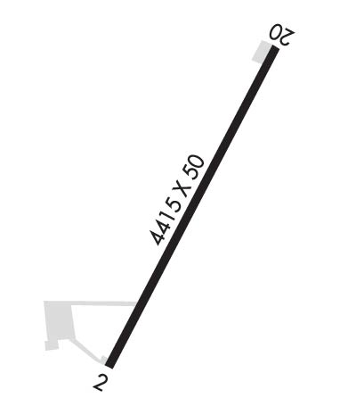
Runway Identifications
Runway Identification: 02/20Length: 4415 ft
Width: 50 ft
Surface: ASPHALT-FAIR CONDITION
Edge lights: Medium IntensityTreatment: NONE
| | Runway: 02 | | Runway: 20 |
| Mag heading: | N/A | Mag heading: | N/A |
| Rwy Slope: | -1.20% Down | Rwy Slope: | 1.20% Up |
| Approach: | | Approach: | |
| Pattern: | Left Traffic | Pattern: | Left Traffic |
| Markings: | BASIC | Markings: | BASIC |
| Marking Condition: | FAIR | Marking Condition: | FAIR |
| Arresting Dev: | | Arresting Dev: | |
| Lat & Long: | N4132.9 W12010.2 | Lat. & Long.: | N4133.5 W12009.7 |
| Elev: | 4623.0 ft. MSL | Elev: | 4570.0 ft. MSL |
| TCH: | | TCH: | |
| Visual Glide Path: | | Visual Glide Path: | |
| Displaced Threshold: | 120 feet | Displaced Threshold: | No |
| Touchdown Zone: | NO | Touchdown Zone: | NO |
| Touchdown Elev.: | | Touchdown Elev.: | |
| Visual Glide Slope: | | Visual Glide Slope: | |
| RVR Equipment: | | RVR Equipment: | |
| RVV Equipment: | NO | RVV Equipment: | NO |
| Approach Lights: | | Approach Lights: | |
| REIL: | NO | REIL: | NO |
| Centerline Lights: | NO | Centerline Lights: | NO |
| Touchdown lights: | NO | Touchdown lights: | NO |
| Runway Category: | Runway with a Visual Approach | Runway Category: | Runway with a Visual Approach |
| Declared Distances: | | Declared Distances: | |
| Obstructions: | ROAD | Obstructions: | |
| Marked: | NOT Marked/Lighted | Marked: | |
| Clearance slope: | 3:1; RWY 02 APCH RATIO 24:1 TO DSPLCD THR. | Clearance slope: | 20:1 |
| Obstruction height: | 15 feet AGL | Obstruction height: | |
| Dist. from runway: | 250 feet | Dist. from runway: | |
| Centerline offset: | 130 right of centerline | Centerline offset: | |
| Comments: | | Comments: | |