
| |||||||||||||||||||||||||||||||||||||||||||||||||||||||||||||||||||||
| |||||||||||||||||||||||||||||||||||||||||||||||||||||||||||||||||||||
| Rwy | Rwy | |||||||
| 5000x60 | 5000' | 5000x60 | 5000' | |||||
| Runway ID | Single Wheel | Double Wheel | Double Tandem Wheel | Dual Double Wheel |
| 14/32 | 12,000 | N/A | N/A | N/A |
| These numbers are Advisory and are not limits. The Airport Manager should have more accurate Weight Limits | ||||
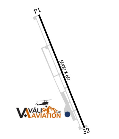 Airport Diagram might not be current. | |
| Facility Name: | WEED |
| City Name: | WEED |
| County: | SISKIYOU |
| State abbrev: | CA |
| State Name: | CALIFORNIA |
| Ownership: | PUBLICLY OWNED |
| Use: | OPEN TO THE PUBLIC |
| Owner's Name: | COUNTY OF SISKIYOU |
| Address: | 190 GREENHORN ROAD |
| YREKA, CA 96097 | |
| Owner's Phone: | (530) 842-8220 |
| Manager's Name: | ANGIE STUMBAUGH; DIRECTOR OF AIRPORTS OFFICE IN YREKA. ASTUMBAUGH@CO.SISKIYOU.CA.US. |
| Address: | 190 GREENHORN ROAD |
| YREKA, CA 96097 | |
| Phone: | 530-842-8297; PHONE RINGS AT COUNTY AIRPORT OFFICE - YREKA |
| FAA Region: | WESTERN-PACIFIC |
| FAA Field Office: | SFO |
| Date | Sunrise | Sunset |
|---|---|---|
| 04/16/24 Tuesday | 6:27 | 19:52 |
| 04/17/24 Wednesday | 6:26 | 19:53 |
| 04/18/24 Thursday | 6:24 | 19:54 |
| 04/19/24 Friday | 6:23 | 19:56 |
| 04/20/24 Saturday | 6:21 | 19:57 |
| 04/21/24 Sunday | 6:20 | 19:58 |
| 04/22/24 Monday | 6:18 | 19:59 |
| 04/23/24 Tuesday | 6:17 | 20:00 |
| 04/24/24 Wednesday | 6:15 | 20:01 |
| 04/25/24 Thursday | 6:14 | 20:02 |
| 04/26/24 Friday | 6:12 | 20:03 |
| 04/27/24 Saturday | 6:11 | 20:04 |
| 04/28/24 Sunday | 6:10 | 20:05 |
| 04/29/24 Monday | 6:08 | 20:06 |
| Airport Attendance Schedule | MAY-OCT MON-SUN 0800-1700, NOV-APR MON-FRI 0800-1700 |
| Airport Status | OPERATIONAL (This Status can change at any time - please check NOTAMS) |
| Airport Lighting Schedule | ACTVT MIRL RY 14/32 - CTAF. |
| Airport Storage Available | Tie Downs |
| Extra Services Available | NONE |
| Wind Indicator | YES - (lighted) |
| Control Tower | NO |
| CTAF Frequency | 122.700 |
| Unicom Frequency | 122.700 |
| Rotating Beacon Color | WG |
| Segmented Circle | YES |
| Landing Fee | YES |
| Airport Inspected | STATE - performed by STATE AERONAUTICAL PERSONNEL |
| Inspection Date | 02/13/2024 |
| Type of Fuel Available | Grade 100LL, JET A (freeze point -40C) |
| Airframe Repair Service | NONE |
| Power Plant Repair Service | NONE |
| Latitude | N4128.8 |
| Longitude | W12227.3 (ESTIMATED) |
| Arpt Elevation | 2942ft (SURVEYED) |
| Magnetic Variation | 14E |
| 4 miles NW | of WEED |
| Traffic Pattern Altitude | |
| Sectional Chart | KLAMATH FALLS |
| Operations (Reported) | Yearly | Avg. Daily |
|---|---|---|
| General Aviation Transient | 6000 | 16 |
| General Aviation Local | 4000 | 11 |
| Air Taxi | 150 | 0 |
| Commerical | 0 | 0 |
| Commuter | 0 | 0 |
| Military | 0 | 0 |
| Aircraft based on Field | |
|---|---|
| General Aviation Singles | 11 |
| General Aviation Multi | 2 |
| Jet Aircraft | 0 |
| General Aviation Helicopters | 0 |
| Military Aircraft | 0 |
| Gliders | 0 |
| Ultralights | 0 |
| FSS on field | NO |
| FSS tie-in | RANCHO MURIETA |
| FSS Phone | 1-800-WX-BRIEF |
| Who issues Notams | RIU |
| Notam D service at airport | YES |
| ARTCC Name | SEATTLE |
| Airport Certification | |
| Aircraft Rescue & Firefighting Index | None |
| Airport of Entry | No |
| Custom Landing Rights | No |
| Joint Civil/Military | No |
| Military Landing rights | YES |
| NATIONAL PLAN OF INTEGRATED AIRPORT SYSTEMS (NPIAS) |
| GRANT AGREEMENTS UNDER FAAP/ADAP/AIP |
| CONVEYANCE UNDER SCETION 16, FEDERAL AIRPORT ACT OF 1946 OR SECTION 23, AIRPORT AND AIRWAY DEVELOPMENT ACT OF 1970 |
| ASSURANCES PURSUANT TO TITLE VI, CIVIL RIGHTS ACT OF 1964 |
| (E81) TAXIWAY LIGHTS AT ENTRANCES ONLY. |
| RAMP TAXIWAYS CLSD NEAR MIDFIELD INTERSECTION AND NEAR SOUTH RAMP EXIT. |
| FOR CD CTC SEATTLE ARTCC AT 253-351-3694. |
Airport Communications & Frequencies:
| |||||||||
| Runway: 14 | Runway: 32 | ||
| Mag heading: | N/A | Mag heading: | N/A |
| Rwy Slope: | .72% Up | Rwy Slope: | -.72% Down |
| Approach: | Approach: | ||
| Pattern: | Right Traffic | Pattern: | Left Traffic |
| Markings: | BASIC | Markings: | BASIC |
| Marking Condition: | GOOD | Marking Condition: | GOOD |
| Arresting Dev: | Arresting Dev: | ||
| Lat & Long: | N4129.2 W12227.5 | Lat. & Long.: | N4128.5 W12227.1 |
| Elev: | 2906.7 ft. MSL | Elev: | 2942.7 ft. MSL |
| TCH: | 23 ft. AGL | TCH: | 20 ft. AGL |
| Visual Glide Path: | 3.00 degrees | Visual Glide Path: | 3.00 degrees |
| Displaced Threshold: | No | Displaced Threshold: | No |
| Touchdown Zone: | YES | Touchdown Zone: | YES |
| Touchdown Elev.: | 2933.6 feet | Touchdown Elev.: | 2942.7 feet |
| Visual Glide Slope: | 2-Box VASI on LEFT side of Runway | Visual Glide Slope: | 2-Box VASI on LEFT side of Runway |
| RVR Equipment: | RVR Equipment: | ||
| RVV Equipment: | NO | RVV Equipment: | NO |
| Approach Lights: | Approach Lights: | ||
| REIL: | NO | REIL: | NO |
| Centerline Lights: | NO | Centerline Lights: | NO |
| Touchdown lights: | NO | Touchdown lights: | NO |
| Runway Category: | Runway with a Visual Approach | Runway Category: | Runway with a Visual Approach |
| Declared Distances: | Declared Distances: | ||
| Obstructions: | Obstructions: | ROAD | |
| Marked: | Marked: | NOT Marked/Lighted | |
| Clearance slope: | 50:1 | Clearance slope: | 46:1 |
| Obstruction height: | Obstruction height: | 15 feet AGL | |
| Dist. from runway: | Dist. from runway: | 900 feet | |
| Centerline offset: | Centerline offset: | ||
| Comments: | Comments: |


