
| ||||||||||||||||||||||||||||||||||||||||||||
| ||||||||||||||||||||||||||||||||||||||||||||
| Rwy | Rwy | |||||||
| 3013x75 | 3013' | 3013x75 | 3013' | |||||
| Runway ID | Single Wheel | Double Wheel | Double Tandem Wheel | Dual Double Wheel |
| 10/28 | 20,000 | N/A | N/A | N/A |
| These numbers are Advisory and are not limits. The Airport Manager should have more accurate Weight Limits | ||||
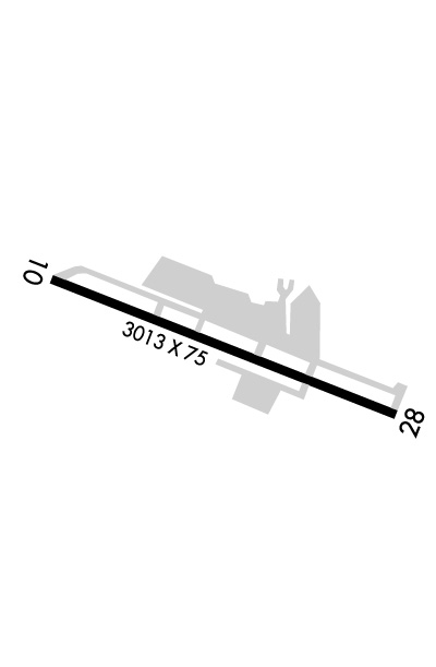 Airport Diagram might not be current. | |
| Facility Name: | OAKDALE |
| City Name: | OAKDALE |
| County: | STANISLAUS |
| State abbrev: | CA |
| State Name: | CALIFORNIA |
| Ownership: | PUBLICLY OWNED |
| Use: | OPEN TO THE PUBLIC |
| Owner's Name: | CITY OF OAKDALE |
| Address: | 455 SOUTH FIFTH AVENUE |
| OAKDALE, CA 95361 | |
| Owner's Phone: | 209-845-3600 |
| Manager's Name: | IAN SATHER; PUBLIC WORKS MAINTENANCE CONTACT: MICHAEL RENFROW (209) 845-3600; CELL (209) 840-1934 |
| Address: | 455 SOUTH FIFTH AVENUE |
| OAKDALE, CA 95361 | |
| Phone: | (209) 845-3640 |
| FAA Region: | WESTERN-PACIFIC |
| FAA Field Office: | SFO |
| Date | Sunrise | Sunset |
|---|---|---|
| 04/22/24 Monday | 6:18 | 19:46 |
| 04/23/24 Tuesday | 6:16 | 19:47 |
| 04/24/24 Wednesday | 6:15 | 19:48 |
| 04/25/24 Thursday | 6:14 | 19:49 |
| 04/26/24 Friday | 6:12 | 19:50 |
| 04/27/24 Saturday | 6:11 | 19:51 |
| 04/28/24 Sunday | 6:10 | 19:52 |
| 04/29/24 Monday | 6:09 | 19:53 |
| 04/30/24 Tuesday | 6:08 | 19:54 |
| 05/01/24 Wednesday | 6:07 | 19:54 |
| 05/02/24 Thursday | 6:05 | 19:55 |
| 05/03/24 Friday | 6:04 | 19:56 |
| 05/04/24 Saturday | 6:03 | 19:57 |
| 05/05/24 Sunday | 6:02 | 19:58 |
| Airport Attendance Schedule | 7 Days A Week DALGT; NIGHTS ON CALL 1-800-868-8750. |
| Airport Status | OPERATIONAL (This Status can change at any time - please check NOTAMS) |
| Airport Lighting Schedule | ACTVT MIRL RWY 10/28 - CTAF. REIL RWY 10 & 28; VASI RWY 10; PAPI RWY 28 OPR CONSLY. |
| Airport Storage Available | Tie Downs |
| Extra Services Available | Aircraft Rental |
| Wind Indicator | YES - (lighted) |
| Control Tower | NO |
| CTAF Frequency | 122.800 |
| Unicom Frequency | 122.800 |
| Rotating Beacon Color | WG |
| Segmented Circle | YES |
| Landing Fee | NO |
| Airport Inspected | STATE - performed by STATE AERONAUTICAL PERSONNEL |
| Inspection Date | 01/11/2024 |
| Type of Fuel Available | Grade 100LL |
| Airframe Repair Service | NONE |
| Power Plant Repair Service | NONE |
| Latitude | N3745.4 |
| Longitude | W12048.0 (ESTIMATED) |
| Arpt Elevation | 236ft (SURVEYED) |
| Magnetic Variation | 15E |
| 3 miles SE | of OAKDALE |
| Traffic Pattern Altitude | |
| Sectional Chart | SAN FRANCISCO |
| Operations (Reported) | Yearly | Avg. Daily |
|---|---|---|
| General Aviation Transient | 4943 | 14 |
| General Aviation Local | 5573 | 15 |
| Air Taxi | 0 | 0 |
| Commerical | 0 | 0 |
| Commuter | 0 | 0 |
| Military | 0 | 0 |
| Aircraft based on Field | |
|---|---|
| General Aviation Singles | 36 |
| General Aviation Multi | 1 |
| Jet Aircraft | 0 |
| General Aviation Helicopters | 3 |
| Military Aircraft | 0 |
| Gliders | 0 |
| Ultralights | 1 |
| FSS on field | NO |
| FSS tie-in | RANCHO MURIETA |
| FSS Phone | 1-800-WX-BRIEF |
| Who issues Notams | RIU |
| Notam D service at airport | YES |
| ARTCC Name | OAKLAND |
| Airport Certification | |
| Aircraft Rescue & Firefighting Index | None |
| Airport of Entry | No |
| Custom Landing Rights | No |
| Joint Civil/Military | No |
| Military Landing rights | YES |
| NATIONAL PLAN OF INTEGRATED AIRPORT SYSTEMS (NPIAS) |
| GRANT AGREEMENTS UNDER FAAP/ADAP/AIP |
| ASSURANCES PURSUANT TO TITLE VI, CIVIL RIGHTS ACT OF 1964 |
| APRON ON SOUTH SIDE OF RY DAMAGED & UNUSABLE. |
| FOR CD CTC NORCAL APCH AT 916-361-0516. |
| RWY 28 APCH RWY SAFETY AREA BISECTED BY AN IRRIGATION CANAL 230 FT FROM THE RWY END. |
Airport Communications & Frequencies:
| ||||||||||||||
| Runway: 10 | Runway: 28 | ||
| Mag heading: | 96° | Mag heading: | 276° |
| Rwy Slope: | .41% Up | Rwy Slope: | -.41% Down |
| Approach: | Approach: | ||
| Pattern: | Left Traffic | Pattern: | Left Traffic |
| Markings: | NONPRECISION INSTRUMENT | Markings: | NONPRECISION INSTRUMENT |
| Marking Condition: | GOOD | Marking Condition: | GOOD |
| Arresting Dev: | Arresting Dev: | ||
| Lat & Long: | N3745.5 W12048.3 | Lat. & Long.: | N3745.3 W12047.7 |
| Elev: | 224.0 ft. MSL | Elev: | 236.5 ft. MSL |
| TCH: | 26 ft. AGL | TCH: | 25 ft. AGL |
| Visual Glide Path: | 2.50 degrees | Visual Glide Path: | 3.00 degrees |
| Displaced Threshold: | No | Displaced Threshold: | No |
| Touchdown Zone: | YES | Touchdown Zone: | YES |
| Touchdown Elev.: | 236.3 feet | Touchdown Elev.: | 236.5 feet |
| Visual Glide Slope: | 2-Box VASI on LEFT side of Runway | Visual Glide Slope: | 2-Light PAPI on LEFT side of Runway |
| RVR Equipment: | RVR Equipment: | ||
| RVV Equipment: | NO | RVV Equipment: | NO |
| Approach Lights: | Approach Lights: | ||
| REIL: | YES | REIL: | YES |
| Centerline Lights: | NO | Centerline Lights: | NO |
| Touchdown lights: | NO | Touchdown lights: | NO |
| Runway Category: | Runway with a Non-precision Approach | Runway Category: | Runway with a Non-precision Approach |
| Declared Distances: | Declared Distances: |
