Current Weather/Notams (Metars, TAFs, Notams, NWS Forecast, PIREPS, and nearby weather)
Customs Information Send updates to Support@FltPlan.com
Customs Not Available
Database effective 05/16/2024
Airport Diagram might not be current.
|
| Facility Name: | COLUMBIA |
| City Name: | COLUMBIA |
| County: | TUOLUMNE |
| State abbrev: | CA |
| State Name: | CALIFORNIA |
| | |
| Ownership: | PUBLICLY OWNED |
| Use: | OPEN TO THE PUBLIC |
| Owner's Name: | COUNTY OF TUOLUMNE |
| Address: | 2 SOUTH GREEN ST. |
| | SONORA, CA 95370 |
| Owner's Phone: | 209-533-5685 |
| | |
| Manager's Name: | KIM MACFARLANE |
| Address: | 10723 AIRPORT RD |
| | COLUMBIA, CA 95310 |
| Phone: | (209) 533-6684 |
| | |
| FAA Region: | WESTERN-PACIFIC |
| FAA Field Office: | SFO |
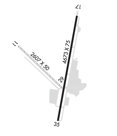
Runway Identifications
Runway Identification: 11/29Length: 2607 ft
Width: 50 ft
Surface: GRASS-GOOD CONDITION
Edge lights: Treatment: NONE
| | Runway: 11 | | Runway: 29 |
| Mag heading: | 118° | Mag heading: | 298° |
| Rwy Slope: | -.88% Down | Rwy Slope: | .88% Up |
| Approach: | | Approach: | |
| Pattern: | Right Traffic | Pattern: | Left Traffic |
| Markings: | NONE | Markings: | NUMBERS ONLY |
| Marking Condition: | | Marking Condition: | GOOD |
| Arresting Dev: | | Arresting Dev: | |
| Lat & Long: | N3802.0 W12025.2 | Lat. & Long.: | N3801.7 W12024.8 |
| Elev: | 2100.6 ft. MSL | Elev: | 2077.6 ft. MSL |
| TCH: | | TCH: | |
| Visual Glide Path: | | Visual Glide Path: | |
| Displaced Threshold: | No | Displaced Threshold: | No |
| Touchdown Zone: | YES | Touchdown Zone: | YES |
| Touchdown Elev.: | 2100.6 feet | Touchdown Elev.: | 2100.6 feet |
| Visual Glide Slope: | | Visual Glide Slope: | |
| RVR Equipment: | | RVR Equipment: | |
| RVV Equipment: | NO | RVV Equipment: | NO |
| Approach Lights: | | Approach Lights: | |
| REIL: | NO | REIL: | NO |
| Centerline Lights: | NO | Centerline Lights: | NO |
| Touchdown lights: | NO | Touchdown lights: | NO |
| Runway Category: | Runway with a Visual Approach | Runway Category: | Runway with a Visual Approach |
| Declared Distances: | | Declared Distances: | |
| Obstructions: | TREES | Obstructions: | TREES |
| Marked: | NOT Marked/Lighted | Marked: | NOT Marked/Lighted |
| Clearance slope: | 16:1 | Clearance slope: | 13:1 |
| Obstruction height: | 135 feet AGL | Obstruction height: | 115 feet AGL |
| Dist. from runway: | 2190 feet | Dist. from runway: | 1600 feet |
| Centerline offset: | 125 left of centerline | Centerline offset: | 100 feet right of centerline |
| Comments: | | Comments: | |
Runway Identification: 17/35Length: 4673 ft
Width: 75 ft
Surface: ASPHALT-GOOD CONDITION
Edge lights: Medium IntensityTreatment: NONE
| | Runway: 17 | | Runway: 35 |
| Mag heading: | 174° | Mag heading: | 354° |
| Rwy Slope: | -1.01% Down | Rwy Slope: | 1.01% Up |
| Approach: | | Approach: | |
| Pattern: | Right Traffic | Pattern: | Left Traffic |
| Markings: | NONPRECISION INSTRUMENT | Markings: | NONPRECISION INSTRUMENT |
| Marking Condition: | FAIR | Marking Condition: | FAIR |
| Arresting Dev: | | Arresting Dev: | |
| Lat & Long: | N3802.2 W12024.7 | Lat. & Long.: | N3801.4 W12024.9 |
| Elev: | 2120.7 ft. MSL | Elev: | 2073.6 ft. MSL |
| TCH: | 56 ft. AGL | TCH: | 54 ft. AGL |
| Visual Glide Path: | 4.55 degrees | Visual Glide Path: | 4.00 degrees |
| Displaced Threshold: | 598 feet | Displaced Threshold: | 384 feet |
| Touchdown Zone: | YES | Touchdown Zone: | YES |
| Touchdown Elev.: | 2112.2 feet | Touchdown Elev.: | 2104.7 feet |
| Visual Glide Slope: | 2-Box VASI on LEFT side of Runway | Visual Glide Slope: | 2-Box VASI on LEFT side of Runway; RY 35 VASI UNUSABLE BYD 5 DEG LEFT AND RIGHT OF RY CNTRLN. |
| RVR Equipment: | | RVR Equipment: | |
| RVV Equipment: | NO | RVV Equipment: | NO |
| Approach Lights: | | Approach Lights: | |
| REIL: | YES | REIL: | YES |
| Centerline Lights: | NO | Centerline Lights: | NO |
| Touchdown lights: | NO | Touchdown lights: | NO |
| Runway Category: | Runway with a Visual Approach | Runway Category: | Runway with a Non-precision Approach |
| Declared Distances: | | Declared Distances: | |
| Obstructions: | GND | Obstructions: | TREES |
| Marked: | NOT Marked/Lighted | Marked: | NOT Marked/Lighted |
| Clearance slope: | 8:1; APCH RATIO FM DSPLCD THLD 31:1. | Clearance slope: | 24:1; APCH RATIO FM DSPLCD THLD 37:1. |
| Obstruction height: | 33 feet AGL | Obstruction height: | 61 feet AGL |
| Dist. from runway: | 450 feet | Dist. from runway: | 1700 feet |
| Centerline offset: | 125 right of centerline | Centerline offset: | 350 feet right of centerline |
| Comments: | | Comments: | |

