Approach Charts
| FltPlan does not have IFR approach charts available for KO16. |
Current Weather/Notams (Metars, TAFs, Notams, NWS Forecast, PIREPS, and nearby weather)
Customs Information Send updates to Support@FltPlan.com
Customs Not Available
Database effective 05/16/2024
Airport Diagram might not be current.
|
| Facility Name: | GARBERVILLE |
| City Name: | GARBERVILLE |
| County: | HUMBOLDT |
| State abbrev: | CA |
| State Name: | CALIFORNIA |
| | |
| Ownership: | PUBLICLY OWNED |
| Use: | OPEN TO THE PUBLIC |
| Owner's Name: | HUMBOLDT COUNTY |
| Address: | 1106 2ND ST |
| | EUREKA, CA 95501 |
| Owner's Phone: | 707-839-5401 |
| | |
| Manager's Name: | CODY ROGGATZ; ARPT MANAGER LOCATED AT CA REDWOOD COAST-HUMBOLDT COUNTY ARPT. |
| Address: | 3561 BOEING AVE. |
| | MCKINLEYVILLE, CA 95519 |
| Phone: | (707) 839-5402; ARPT MANAGER OFFICE LOCATED AT CA REDWOOD COAST-HUMBOLDT COUNTY ARPT. |
| | |
| FAA Region: | WESTERN-PACIFIC |
| FAA Field Office: | SFO |
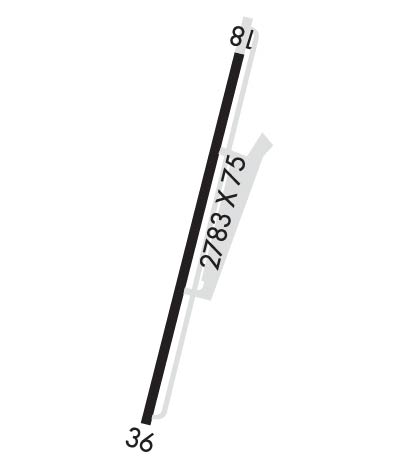
Runway Identifications
Runway Identification: 18/36Length: 2783 ft
Width: 75 ft
Surface: ASPHALT-GOOD CONDITION
Edge lights: Treatment: NONE
| | Runway: 18 | | Runway: 36 |
| Mag heading: | N/A | Mag heading: | N/A |
| Rwy Slope: | .52% Up | Rwy Slope: | -.52% Down |
| Approach: | | Approach: | |
| Pattern: | Left Traffic | Pattern: | Right Traffic |
| Markings: | BASIC | Markings: | BASIC |
| Marking Condition: | GOOD | Marking Condition: | GOOD |
| Arresting Dev: | | Arresting Dev: | |
| Lat & Long: | N4005.3 W12348.8 | Lat. & Long.: | N4004.9 W12348.9 |
| Elev: | 536.5 ft. MSL | Elev: | 550.9 ft. MSL |
| TCH: | | TCH: | |
| Visual Glide Path: | | Visual Glide Path: | |
| Displaced Threshold: | No | Displaced Threshold: | No |
| Touchdown Zone: | YES | Touchdown Zone: | YES |
| Touchdown Elev.: | 550.9 feet | Touchdown Elev.: | 550.9 feet |
| Visual Glide Slope: | | Visual Glide Slope: | |
| RVR Equipment: | | RVR Equipment: | |
| RVV Equipment: | NO | RVV Equipment: | NO |
| Approach Lights: | | Approach Lights: | |
| REIL: | NO | REIL: | NO |
| Centerline Lights: | NO | Centerline Lights: | NO |
| Touchdown lights: | NO | Touchdown lights: | NO |
| Runway Category: | Runway with a Visual Approach | Runway Category: | Runway with a Visual Approach |
| Declared Distances: | | Declared Distances: | |
| Obstructions: | HILL | Obstructions: | TREES |
| Marked: | NOT Marked/Lighted | Marked: | NOT Marked/Lighted |
| Clearance slope: | 11:1 | Clearance slope: | |
| Obstruction height: | 354 feet AGL | Obstruction height: | 25 feet AGL |
| Dist. from runway: | 4250 feet | Dist. from runway: | 200 feet |
| Centerline offset: | | Centerline offset: | 70 feet right of centerline |
| Comments: | RY 18 +6 FT BRUSH @ 50 FT, 90 FT R. | Comments: | RWY 36 0-20 FT RISING TERRAIN 0-200 FT. |

