Click here for more info on on SMS!

KO15

TURLOCK MUNI
TURLOCK
CA
Time Zone: Pacific
Lat: N 3729.0
Long: W 12041.8
Elev: 161
Var: -16
Longest Runway: 2985
CTAF: 122.8

FBO & Flight Services info for KO15

FBOs: Update your Fuel Prices

TURLOCK MUNIPh: 209-202-8869 Fax: 209-632-1104 Freq: 122.8
Service
Jet
100LL
SAF
MoGas
Fuel Avail: ~~Unattended
Full        Last Update: 04/23/2024 05:40:09

Self  5.55    
 Address: 13604 NEWPORT RD   BALLICO, CA 95303
If you are an FBO, call 1-203-262-1700 to update your info or email: FltPlan.Advertising@garmin.com
Advertise your FBO on FltPlan.com
FBOs at nearby airports who want your business:
Ph: Fax: Freq:

Runway & Approach Info for KO15
Rwy
Length
Land Dist**
Approach*
  Rwy
Length
Land Dist**
Approach*
12
2985x50  2985'          
 
  
30
  2985x50  2985'          
 
 * only ILS, LOC, LDA, and SDF approaches to a specific runway are shown
** For any Declared Landing Distance Available, please see A/FD or Approach plates
Runway Weight Capability (lbs.) Help
Runway IDSingle WheelDouble WheelDouble Tandem WheelDual Double Wheel
12/3012,000N/AN/AN/A
These numbers are Advisory and are not limits.   The Airport Manager should have more accurate Weight Limits
Approach Charts
FltPlan does not have IFR approach charts available for KO15.
Current Weather/Notams
Customs Information Send updates to Support@FltPlan.com
Customs Not Available
Database effective 05/16/2024
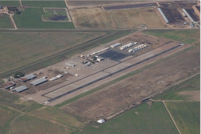
Facility Name: TURLOCK MUNI
City Name: TURLOCK
County: MERCED
State abbrev: CA
State Name: CALIFORNIA
   
Ownership: PUBLICLY OWNED
Use: OPEN TO THE PUBLIC
Owner's Name: CITY OF TURLOCK; ATTN: ERICK SCHULZE
Address: 156 S. BROADWAY
 TURLOCK, CA 95380
Owner's Phone: 209-668-5542
  
Manager's Name: ERIK SCHULZE
Address: 144 S. BROADWAY
 TURLOCK, CA 95380
Phone: (209) 668-5599; X 4604
   
FAA Region: WESTERN-PACIFIC
FAA Field Office: SFO


Sunrise / Sunset times for TURLOCK MUNI

DateSunriseSunset
04/22/24 Monday6:1819:45
04/23/24 Tuesday6:1619:46
04/24/24 Wednesday6:1519:47
04/25/24 Thursday6:1419:48
04/26/24 Friday6:1219:49
04/27/24 Saturday6:1119:50
04/28/24 Sunday6:1019:51
04/29/24 Monday6:0919:52
04/30/24 Tuesday6:0819:53
05/01/24 Wednesday6:0719:53
05/02/24 Thursday6:0519:54
05/03/24 Friday6:0419:55
05/04/24 Saturday6:0319:56
05/05/24 Sunday6:0219:57

Airport Facilities

Airport Attendance ScheduleUNATTENDED
Airport Status OPERATIONAL (This Status can change at any time - please check NOTAMS)
Airport Lighting ScheduleACTVT LIRL RWY 12/30 - CTAF.
Airport Storage AvailableTie Downs
Extra Services AvailableNONE
Wind IndicatorYES - (lighted)
Control TowerNO
CTAF Frequency122.800
Unicom Frequency122.800
Rotating Beacon ColorWG
Segmented CircleYES
Landing FeeNO

Airport Inspection Data

Airport InspectedSTATE - performed by STATE AERONAUTICAL PERSONNEL
Inspection Date01/11/2024

Airport Services

Type of Fuel AvailableGrade 100LL; -10FUEL AVBL 24 HRS SELF SERVE CC.
Airframe Repair ServiceNONE
Power Plant Repair ServiceNONE

Geographic Data

LatitudeN3729.0
LongitudeW12041.8 (ESTIMATED)
Arpt Elevation160ft (SURVEYED)
Magnetic Variation16E
8 miles Eof TURLOCK
Traffic Pattern Altitude800
Sectional ChartSAN FRANCISCO

Aircraft Data

Operations (Reported)YearlyAvg. Daily
General Aviation Transient 24507
General Aviation Local 902025
Air Taxi 00
Commerical 00
Commuter 00
Military 00
Aircraft based on Field
General Aviation Singles 28
General Aviation Multi 2
Jet Aircraft 0
General Aviation Helicopters 0
Military Aircraft 0
Gliders 0
Ultralights 0

FAA Services

FSS on field NO
FSS tie-in RANCHO MURIETA
FSS Phone 1-800-WX-BRIEF
Who issues Notams RIU
Notam D service at airport YES
ARTCC Name OAKLAND

Federal Status

Airport Certification
Aircraft Rescue & Firefighting IndexNone
Airport of EntryNo
Custom Landing RightsNo
Joint Civil/MilitaryNo
Military Landing rightsYES

Federal Agreements

NATIONAL PLAN OF INTEGRATED AIRPORT SYSTEMS (NPIAS)
SURPLUS PROPERTY AGREEMENT UNDER REGULATION 16-WAA

Remarks

FOR CD CTC NORCAL APCH AT 916-361-0516.
RWY 12/3 0 NSTD LIRL; LGTS 20 FT FM EDGE OF RY.
Runway Identifications
Runway Identification: 12/30
Length: 2985 ft
Width: 50 ft
Surface: ASPHALT-FAIR CONDITION
Edge lights: Non-Standard Lighting System

Treatment: NONE

 Runway: 12   Runway: 30
Mag heading: N/AMag heading: N/A
Rwy Slope: -.01% DownRwy Slope: .01% Up
Approach: Approach:
Pattern: Left TrafficPattern: Left Traffic
Markings: BASICMarkings: BASIC
Marking Condition: FAIRMarking Condition: FAIR
Arresting Dev: Arresting Dev:
Lat & Long: N3729.2  W12042.1Lat. & Long.: N3728.9  W12041.6
Elev: 160.8 ft. MSLElev: 160.6 ft. MSL
TCH: TCH:
Visual Glide Path: Visual Glide Path:
Displaced Threshold: NoDisplaced Threshold: No
Touchdown Zone: YESTouchdown Zone: YES
Touchdown Elev.: 160.8 feetTouchdown Elev.: 160.6 feet
Visual Glide Slope: Visual Glide Slope:
RVR Equipment: RVR Equipment:
RVV Equipment: NORVV Equipment: NO
Approach Lights: Approach Lights:
REIL: NOREIL: NO
Centerline Lights: NOCenterline Lights: NO
Touchdown lights: NOTouchdown lights: NO
Runway Category: Runway with a Visual ApproachRunway Category: Runway with a Visual Approach
Declared Distances: Declared Distances:
Obstructions: POLEObstructions:
Marked: LIGHTEDMarked:
Clearance slope: 20:1Clearance slope: 50:1
Obstruction height: 30 feet AGLObstruction height:
Dist. from runway: 800 feetDist. from runway:
Centerline offset: 130 right of centerlineCenterline offset:
Comments: Comments:
C:/P: