Approach Charts
| FltPlan does not have IFR approach charts available for KO05. |
Current Weather/Notams (Metars, TAFs, Notams, NWS Forecast, PIREPS, and nearby weather)
Customs Information Send updates to Support@FltPlan.com
Customs Not Available
Database effective 05/16/2024
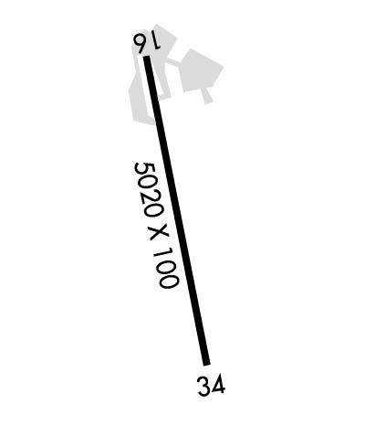
Airport Diagram might not be current.
|
| Facility Name: | ROGERS FLD |
| City Name: | CHESTER |
| County: | PLUMAS |
| State abbrev: | CA |
| State Name: | CALIFORNIA |
| | |
| Ownership: | PUBLICLY OWNED |
| Use: | OPEN TO THE PUBLIC |
| Owner's Name: | COUNTY OF PLUMAS |
| Address: | 198 ANDY'S WAY |
| | QUINCY, CA 95971-7007 |
| Owner's Phone: | 530-283-6299 |
| | |
| Manager's Name: | JD MOORE |
| Address: | 198 ANDY'S WAY |
| | QUINCY, CA 95971-7007 |
| Phone: | 530-283-6069; AIRPORT FBO PHONE 530-258-3616. |
| | |
| FAA Region: | WESTERN-PACIFIC |
| FAA Field Office: | SFO |
Runway Identifications
Runway Identification: 16/34Length: 5020 ft
Width: 100 ft
Surface: ASPHALT-FAIR CONDITION
Edge lights: Medium IntensityTreatment: NONE
| | Runway: 16 | | Runway: 34 |
| Mag heading: | 160° | Mag heading: | 340° |
| Rwy Slope: | -.42% Down | Rwy Slope: | .42% Up |
| Approach: | | Approach: | |
| Pattern: | Left Traffic | Pattern: | Right Traffic |
| Markings: | NONPRECISION INSTRUMENT | Markings: | NONPRECISION INSTRUMENT |
| Marking Condition: | FAIR | Marking Condition: | FAIR |
| Arresting Dev: | | Arresting Dev: | |
| Lat & Long: | N4017.4 W12114.5 | Lat. & Long.: | N4016.5 W12114.4 |
| Elev: | 4534.4 ft. MSL | Elev: | 4513.5 ft. MSL |
| TCH: | 45 ft. AGL | TCH: | 32 ft. AGL |
| Visual Glide Path: | 3.00 degrees | Visual Glide Path: | 3.00 degrees |
| Displaced Threshold: | No | Displaced Threshold: | No |
| Touchdown Zone: | YES | Touchdown Zone: | YES |
| Touchdown Elev.: | 4534.4 feet | Touchdown Elev.: | 4528.7 feet |
| Visual Glide Slope: | 2-Light PAPI on LEFT side of Runway | Visual Glide Slope: | 2-Light PAPI on LEFT side of Runway |
| RVR Equipment: | | RVR Equipment: | |
| RVV Equipment: | NO | RVV Equipment: | NO |
| Approach Lights: | | Approach Lights: | |
| REIL: | NO | REIL: | NO |
| Centerline Lights: | NO | Centerline Lights: | NO |
| Touchdown lights: | NO | Touchdown lights: | NO |
| Runway Category: | Runway with a Visual Approach | Runway Category: | Runway with a Visual Approach |
| Declared Distances: | | Declared Distances: | |
| Obstructions: | TREES | Obstructions: | TREES |
| Marked: | NOT Marked/Lighted | Marked: | NOT Marked/Lighted |
| Clearance slope: | 20:1 | Clearance slope: | 34:1 |
| Obstruction height: | 50 feet AGL | Obstruction height: | 67 feet AGL |
| Dist. from runway: | 1200 feet | Dist. from runway: | 2500 feet |
| Centerline offset: | 375 left of centerline | Centerline offset: | 350 feet left of centerline |
| Comments: | | Comments: | |

