KNYL

YUMA MCAS/YUMA INTL
YUMA
AZ
Time Zone: Pacific
Lat: N 3239.4
Long: W 11436.4
Elev: 213
Var: -13
Longest Runway: 13300
Clr Del: 118.0
Dept. ATIS: 118.8
Arr. ATIS: 118.8
Ground: 121.9
Tower: 119.3

FBO & Flight Services info for KNYL

FBOs: Update your Fuel Prices

MILLION AIRPh: 928-247-9571 Fax: 928-247-9578 Freq: 131.22
Service
Jet
100LL
SAF
MoGas
Fuel Avail: We offer full service and self service fuel for both 100LL and Jet A
Full6.187.71    Last Update: 04/16/2024 13:08

Self5.585.51    
 Address: 3681 S. BURCH WAY   YUMA, AZ 85365
ASOS
-
Freq: 256.4  
If you are an FBO, call 1-203-262-1700 to update your info or email: FltPlan.Advertising@garmin.com
Advertise your FBO on FltPlan.com

Runway & Approach Info for KNYL
Rwy
Length
Land Dist**
Approach*
  Rwy
Length
Land Dist**
Approach*
03L
13300x200  13300'          
 
  
21R
  13300x200  13300'          
ILS
 108.30 - 213°  
03R
9240x150  9240'          
 
  
21L
  9240x150  9240'          
 
08
6146x150  6146'          
 
  
26
  6146x150  6146'          
 
17
5710x150  5710'          
 
  
35
  5710x150  5710'          
 
 * only ILS, LOC, LDA, and SDF approaches to a specific runway are shown
** For any Declared Landing Distance Available, please see A/FD or Approach plates
Runway Weight Capability (lbs.) Help
Runway IDSingle WheelDouble WheelDouble Tandem WheelDual Double Wheel
03L/21R103,000200,000400,000N/A
03R/21L162,000200,000400,000N/A
08/2663,000137,000206,000N/A
17/3572,000171,000255,000N/A
These numbers are Advisory and are not limits.   The Airport Manager should have more accurate Weight Limits
Approach Charts
Approaches    
Current Weather/Notams
Customs Information Send updates to Support@FltPlan.com
Phone 928-314-1295
Fax 928-344-3715

Comments Mon-Fri 0800-1530 1 hr advanced notice required upon entering US airspace. Outside of business hours call 928-627-8854.
Database effective 04/18/2024
Airport Diagram of KNYL
Airport Diagram might not be current.

Facility Name: YUMA MCAS/YUMA INTL
City Name: YUMA
County: YUMA
State abbrev: AZ
State Name: ARIZONA
   
Ownership: NAVY OWNED
Use: OPEN TO THE PUBLIC
Owner's Name: USMC & YUMA CO ARPT AUTH
Address: 2356 E O'NEILL ST, BLDG 153
 YUMA, AZ 85369-9114
Owner's Phone: 928-269-3327
  
Manager's Name: GREGORY MCSHANE; GLADYS BROWN
Address: 2356 E O'NEILL ST, BLDG 153
 YUMA, AZ 85369-9114
Phone: 928-269-3327; 928-726-5882. MIL APCH SUPERVISOR - 928-269-2326.
   
FAA Region: WESTERN-PACIFIC
FAA Field Office: PHX


Sunrise / Sunset times for YUMA MCAS/YUMA INTL

DateSunriseSunset
04/18/24 Thursday6:0419:11
04/19/24 Friday6:0319:12
04/20/24 Saturday6:0219:13
04/21/24 Sunday6:0119:13
04/22/24 Monday6:0019:14
04/23/24 Tuesday5:5919:15
04/24/24 Wednesday5:5819:16
04/25/24 Thursday5:5719:16
04/26/24 Friday5:5619:17
04/27/24 Saturday5:5519:18
04/28/24 Sunday5:5419:18
04/29/24 Monday5:5319:19
04/30/24 Tuesday5:5219:20
05/01/24 Wednesday5:5119:21

Airport Facilities

Airport Attendance Schedule7 Days A Week; MIL OPS HR 1430-0600Z DLY; CLSD HOL. MIL AVN OPS NA 1430-1500Z DLY. VAL/TRANS SVC ABVL MON-FRI 1500-0600Z, CLSD SAT-SUN, HOL.
Airport Status OPERATIONAL (This Status can change at any time - please check NOTAMS)
Airport Lighting ScheduleWHEN ATCT CLSD ACTVT HIRL RWY 08/26 & 17/35; TWYS A, A1, A2, B, C, L, Z - CTAF.
Airport Storage AvailableTie Downs
Extra Services AvailableAir Freight, Air Ambulance, Avionics, Charter, Flight Instruction, Aircraft Rental
Wind IndicatorYES - (lighted)
Control TowerYES
CTAF Frequency119.300
Unicom Frequency122.950
Rotating Beacon ColorWG
Segmented CircleNO
Landing FeeNO

Airport Inspection Data

Airport InspectedFEDERAL - performed by FAA AIRPORTS FIELD PERSONNEL
Inspection Date03/01/2023

Airport Services

Type of Fuel AvailableGrade 100, JET A (freeze point -40C), JET A; -10ON CALL H24.
Airframe Repair ServiceMINOR
Power Plant Repair ServiceMINOR

Geographic Data

LatitudeN3239.4
LongitudeW11436.4 (ESTIMATED)
Arpt Elevation213ft (SURVEYED)
Magnetic Variation13E
3 miles Sof YUMA
Traffic Pattern Altitude
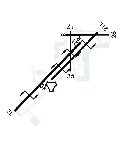
TPA RWY 03L/R RIGHT TRAFFIC 1700 FT; RWY 21L/R LEFT TRAFFIC 1700FT. INITIAL ALT FOR OVERHEAD 4000 FT 6NM. INITIAL ALT FOR STRAIGHT-IN 3000 FT 6NM. COPTER - 700 FT FOR ANY RWY.
Sectional ChartPHOENIX

Aircraft Data

Operations (Reported)YearlyAvg. Daily
General Aviation Transient 00
General Aviation Local 41269113
Air Taxi 00
Commerical 1156532
Commuter 00
Military 83777230
Aircraft based on Field
General Aviation Singles 59
General Aviation Multi 12
Jet Aircraft 5
General Aviation Helicopters 1
Military Aircraft 105
Gliders 0
Ultralights 1

FAA Services

FSS on field NO
FSS tie-in PRESCOTT
FSS Phone 1-800-WX-BRIEF
Who issues Notams NYL
Notam D service at airport YES
ARTCC Name LOS ANGELES

Federal Status

Airport CertificationAIRPORT RECEIVING SCHEDULED AIR CARRIER SERVICE FROM CARRIERS CERTIFICATED BY THE CIVIL AERONAUTICS BOARD
Aircraft Rescue & Firefighting IndexAIRPORT HAS A CERTIFICATE UNDER CFR PART 139
Airport of EntryYES
Custom Landing RightsNo
Joint Civil/MilitaryYES
Military Landing rightsNo

Federal Agreements

NATIONAL PLAN OF INTEGRATED AIRPORT SYSTEMS (NPIAS)
GRANT AGREEMENTS UNDER FAAP/ADAP/AIP
CONVEYANCE UNDER SCETION 16, FEDERAL AIRPORT ACT OF 1946 OR SECTION 23, AIRPORT AND AIRWAY DEVELOPMENT ACT OF 1970
ASSURANCES PURSUANT TO TITLE VI, CIVIL RIGHTS ACT OF 1964
AGREEMENT UNDER DLAND OR DCLA HAS EXPIRED.

Remarks

CTN: JOINT USE CIVIL/MIL ARPT; GEN AVN & ACR OPR VFR ENTER ATA AT 1200 FT WHEN ASGN RWY 08/26 OR 17/35.
HEL ENTER ARPT TFC AREA AT TFC PAT ALT 1200 FT THEN DESCEND TO 700 FT PRIOR TO ALL RWYS.
PART 77 OBSTRNS-RADAR TWR E, POLES NEAR RWY 17.
CTN: TFC PAT RWY 03L/R & 21L/R OVERLAP TFC PAT RWY 08/26 & 17/35.
JASU: 1(NC-10) 1(NCPP-105)
FLUID: LOX LHNIT LPOX
FUEL - F-24(MIL)-AVBL O/R FOR SHIPBOUND ACFT. F-24(MIL). A, A+ (FBO: 928-247-9571; 131.225, AVBL MON-FRI 1300-0400Z, SAT-SUN 1300-0100Z, OT 1 HR MIN PN). (NC-100).
OIL - O-156
RSTD: FLT CLNC MANNED DURG MIL OPS HR - D269-2326/2323/2077, C928-269-2326/2323/2077. TSNT 24 HR PPR - D269-2445/2760, C928-269-2445/2760. AV8B VSTOL TRNG TO RWY 03/21 MAY HAVE PRIORITY MON-FRI OVER MIL PRAC APCH.
MIL USE: ILS RADAR; SEE TERMINAL FLIP FOR RADAR MINIMA.
976 FT STWY RWY 03R; 1000 FT STWY RWY 21L; 1000 FT STWY RWY 03L; 1000 FT STWY RWY 21R; 1000 FT STWY RWY 08; 251 FT STWY RWY 26; 800 FT STWY RWY 17; 262 FT STWY RWY 35.
24 HR PPR FOR ALL TSNT FR VAL C928-269-2445, D269-2445. 24 HR PPR ALL TSNT UTILIZING MIL RAMP; D951-2445/2760, C928-269-2445/2760. MIL ACFT REQ TO RWY 03/21 MAY HAVE PRIORITY MON-SAT OVER PRACTICE APCHS.
MILITARY USE: VHF/DF
MISC: AMBULANCE OPS BTN 0500-1300Z NEEDING GND ACCESS - CIVIL ARPT AUTH C928-941-2396 OR 376-5868.
US CUSTOMS PORT OF ENTRY - 928-344-9572 OR 928- 314-1295.
CIVIL ARPT OPS - 928-726-5882 EXTN 2161 OR 928-941-2396
MIL ARPT OPS - 928-269-2077.
TWY A2 PCN 33/F/B/W/T, TWY K PCN 30/G/B/W/T, TWY L PCN 33/F/B/W/T, TWY Z PCN 33/F/B/W/T
ROTARY WING ACFT RECOVERY NA TO VTOL PAD-4.
CTN: AVOID OVFT MEXICAN BORDER 7 NM W, JET TRNG OPS INVOF. HIGH VOLUME LCL AREA OPS ON UHF; VHF OPS EXER CTN & STRICT COMPLIANCE TO ATC INSTR.
AVOID OVFT OF MCAS YUMA INFRASTRUCTURE E OF MAIN APRON.
OPS HR APPLIES TO MIL INCLG YUMA INTL & FBO; AFT HR TWO WEEK PPR IN WRITING - 928-269-3327/D269-3327.
FOD RSTRN: HVY/WIDE BODY ARR/DEP RWY 03L/21R ONLY; MCAS YUMA S MAIN PRKG APN/VAL BACK TAX RWY 03L/21R THEN TWY D; YUMA INTL/MILLION AIR YUMA FBO DEF CONTRR CMPLX PRKG APN BACK TAX RWY 03L/21R THEN TWY H1 OR F1. OTR RWY OR TWY NA. HVY/WIDE BODY ENG RUNUPS ON RWY NA EXC USAF 1/2.
ARFF NA AFT OPS HR EXC SKED PART 121 ACR.
FOR CD CTC YUMA CERAP AT 982-269-9569.
F/W, R/W & F35 RAPID RFL HOT PIT AVBL DURG ATCT HR WITH 24 HR PPR - 928-247-9571 OR 131.225; 2 ACFT SIMUL OPS AVBL; ADZ ATC & PROCD TO S RAMP OFF TWY Z3.
GEN AVN & ACR VFR DEP FLY RWY HDG MNTN 1200 FT UNTIL OUTSIDE ATA UNLESS OTRW APVD BY TWR.
MIL JET OPS FM 4000-3000 FT MSL DESCENDING TO 1700 FT MSL WI 6 NM SW STRAIGHT-IN RWY 03L & 03R & WI 6 NM NE STRAIGHT-IN RWY 21R & 21L.
Airport Communications & Frequencies:
ATIS Frequencies:   Hours(local) of Operation: 24 HRS
118.8
273.5
YUMA Tower Frequencies:   Hours(local) of operation: 1430-0600Z DLY, CLSD HOL. MIL AVN OPS NOT AUTHORIZED 1430-1500Z DLY DUE TO AFLD MAINT.   
119.3
377.075
YUMA Ground Frequencies:
121.9
314.0
Emergency Frequencies:
121.5
243.0
CTAF Frequency:
119.300
Unicom Frequency:
122.950
Remarks
  • APCH CTL SVC PRVVD BY YUMA CERAP ON 124.7/371.975 (YUMA RCAG). DEP CTL SVC PRVDD BY YUMA CERAP ON 125.5/282.325 (YUMA/A RCAG).
  • PMSV AVBL MON-FRI 1400-2330Z.
  • Runway Identifications
    Runway Identification: 03L/21R
    Length: 13300 ft
    Width: 200 ft
    Surface: CONCRETE-GOOD CONDITION
    Edge lights: High Intensity

    Treatment: NONE
    Weight: PCN 71 /R/C/W/T

     Runway: 03L   Runway: 21R
    Mag heading: 31°Mag heading: 211°
    Rwy Slope: .00% UpRwy Slope: .00% Down
    Approach: Approach: ILS
    Pattern: Right TrafficPattern: Left Traffic
    Markings: PRECISION INSTRUMENTMarkings: PRECISION INSTRUMENT
    Marking Condition: GOODMarking Condition: GOOD
    Arresting Dev: E28; HOOK E28(B) (3495 FT)Arresting Dev: E28; HOOK E28(B) (1699 FT)
    Lat & Long: N3238.2  W11437.8Lat. & Long.: N3239.8  W11436.0
    Elev: 192.6 ft. MSLElev: 192.7 ft. MSL
    TCH: 53 ft. AGLTCH: 50 ft. AGL
    Visual Glide Path: 3.00 degreesVisual Glide Path: 3.00 degrees
    Displaced Threshold: NoDisplaced Threshold: No
    Touchdown Zone: YESTouchdown Zone: YES
    Touchdown Elev.: 195.4 feetTouchdown Elev.: 192.7 feet
    Visual Glide Slope: 4-Light PAPI on LEFT side of RunwayVisual Glide Slope: 4-Light PAPI on LEFT side of Runway
    RVR Equipment: RVR Equipment:
    RVV Equipment: NORVV Equipment: NO
    Approach Lights: Approach Lights: MALSR - 1,400 foot medium intensity approach lighting system with runway alignment indicator lights
    REIL: YESREIL: NO
    Centerline Lights: NOCenterline Lights: NO
    Touchdown lights: NOTouchdown lights: NO
    Runway Category: Precision Instrument RunwayRunway Category: Precision Instrument Runway
    Declared Distances: TORA:13300' TODA:13300' ASDA:13300' LDA:13300'Declared Distances: TORA:13300' TODA:13300' ASDA:13300' LDA:13300'
    Runway Identification: 03R/21L
    Length: 9240 ft
    Width: 150 ft
    Surface: CONCRETE ASPHALT-GOOD CONDITION
    Edge lights: High Intensity

    Treatment: NONE
    Weight: PCN 59 /F/B/W/T

     Runway: 03R   Runway: 21L
    Mag heading: 31°Mag heading: 211°
    Rwy Slope: .21% UpRwy Slope: -.21% Down
    Approach: Approach:
    Pattern: Right TrafficPattern: Left Traffic
    Markings: NONPRECISION INSTRUMENTMarkings: NONPRECISION INSTRUMENT
    Marking Condition: GOODMarking Condition: GOOD
    Arresting Dev: E5; HOOK E28(B) (2725 FT)Arresting Dev: E5; HOOK E28(B) (1675 FT)
    Lat & Long: N3238.9  W11436.8Lat. & Long.: N3240.0  W11435.5
    Elev: 188.0 ft. MSLElev: 207.6 ft. MSL
    TCH: 50 ft. AGLTCH: 51 ft. AGL
    Visual Glide Path: 3.00 degreesVisual Glide Path: 3.00 degrees
    Displaced Threshold: NoDisplaced Threshold: No
    Touchdown Zone: YESTouchdown Zone: YES
    Touchdown Elev.: 188.0 feetTouchdown Elev.: 207.6 feet
    Visual Glide Slope: 4-Light PAPI on LEFT side of RunwayVisual Glide Slope: 4-Light PAPI on LEFT side of Runway
    RVR Equipment: RVR Equipment:
    RVV Equipment: NORVV Equipment: NO
    Approach Lights: Approach Lights:
    REIL: YESREIL: YES
    Centerline Lights: NOCenterline Lights: NO
    Touchdown lights: NOTouchdown lights: NO
    Runway Category: Runway with a Visual ApproachRunway Category: Runway with a Visual Approach
    Declared Distances: TORA:9240' TODA:9240' ASDA:9240' LDA:9240'Declared Distances: TORA:9240' TODA:9240' ASDA:9240' LDA:9240'
    Obstructions: ANTObstructions: ROAD
    Marked: LIGHTEDMarked: NOT Marked/Lighted
    Clearance slope: 15:1Clearance slope: 50:1
    Obstruction height: 29 feet AGLObstruction height: 18 feet AGL
    Dist. from runway: 650 feetDist. from runway: 1250 feet
    Centerline offset: 300 left of centerlineCenterline offset:
    Comments: Comments:
    Runway Identification: 08/26
    Length: 6146 ft
    Width: 150 ft
    Surface: ASPHALT-GOOD CONDITION
    Edge lights: High Intensity

    Treatment: NONE
    Weight: PCN 33 /F/B/W/T

     Runway: 08   Runway: 26
    Mag heading: 76°Mag heading: 256°
    Rwy Slope: .30% UpRwy Slope: -.30% Down
    Approach: Approach:
    Pattern: Right TrafficPattern: Left Traffic
    Markings: BASICMarkings: BASIC
    Marking Condition: GOODMarking Condition: GOOD
    Arresting Dev: Arresting Dev:
    Lat & Long: N3240.0  W11436.3Lat. & Long.: N3240.0  W11435.1
    Elev: 194.7 ft. MSLElev: 213.3 ft. MSL
    TCH: TCH:
    Visual Glide Path: Visual Glide Path:
    Displaced Threshold: NoDisplaced Threshold: No
    Touchdown Zone: YESTouchdown Zone: YES
    Touchdown Elev.: 201.4 feetTouchdown Elev.: 213.3 feet
    Visual Glide Slope: Visual Glide Slope:
    RVR Equipment: RVR Equipment:
    RVV Equipment: NORVV Equipment: NO
    Approach Lights: Approach Lights:
    REIL: NOREIL: NO
    Centerline Lights: NOCenterline Lights: NO
    Touchdown lights: NOTouchdown lights: NO
    Runway Category: Runway with a Visual ApproachRunway Category: Runway with a Visual Approach
    Declared Distances: TORA:6146' TODA:6146' ASDA:6146' LDA:6146'Declared Distances: TORA:6146' TODA:6146' ASDA:6146' LDA:6146'
    Obstructions: ROADObstructions: ROAD
    Marked: NOT Marked/LightedMarked: NOT Marked/Lighted
    Clearance slope: 19:1Clearance slope: 50:1
    Obstruction height: 15 feet AGLObstruction height: 14 feet AGL
    Dist. from runway: 490 feetDist. from runway: 1250 feet
    Centerline offset: Centerline offset:
    Comments: 18 FT WINDSOCK 130 FT L OF RWY END.Comments:
    Runway Identification: 17/35
    Length: 5710 ft
    Width: 150 ft
    Surface: CONCRETE ASPHALT-GOOD CONDITION
    Edge lights: High Intensity

    Treatment: NONE
    Weight: PCN 33 /F/B/W/T

     Runway: 17   Runway: 35
    Mag heading: 166°Mag heading: 346°
    Rwy Slope: -.24% DownRwy Slope: .24% Up
    Approach: Approach:
    Pattern: Right TrafficPattern: Left Traffic
    Markings: NONPRECISION INSTRUMENTMarkings: NONPRECISION INSTRUMENT
    Marking Condition: GOODMarking Condition: GOOD
    Arresting Dev: Arresting Dev:
    Lat & Long: N3240.1  W11436.2Lat. & Long.: N3239.1  W11436.2
    Elev: 196.3 ft. MSLElev: 182.5 ft. MSL
    TCH: 40 ft. AGLTCH:
    Visual Glide Path: 3.00 degreesVisual Glide Path:
    Displaced Threshold: NoDisplaced Threshold: No
    Touchdown Zone: YESTouchdown Zone: YES
    Touchdown Elev.: 196.7 feetTouchdown Elev.: 188.7 feet
    Visual Glide Slope: 4-BOX VASI ON LEFT SIDE OF RUNWAYVisual Glide Slope:
    RVR Equipment: RVR Equipment:
    RVV Equipment: NORVV Equipment: NO
    Approach Lights: Approach Lights:
    REIL: NOREIL: YES
    Centerline Lights: NOCenterline Lights: NO
    Touchdown lights: NOTouchdown lights: NO
    Runway Category: Runway with a Non-precision Approach having visibility minimums greater than 3/4 mileRunway Category: Runway with a Visual Approach
    Declared Distances: TORA:5710' TODA:5710' ASDA:5710' LDA:5710'Declared Distances: TORA:5710' TODA:5710' ASDA:5710' LDA:5710'
    Obstructions: TREEObstructions: BRUSH
    Marked: NOT Marked/LightedMarked: NOT Marked/Lighted
    Clearance slope: 24:1Clearance slope: 25:1
    Obstruction height: 72 feet AGLObstruction height: 4 feet AGL
    Dist. from runway: 1980 feetDist. from runway: 300 feet
    Centerline offset: 150 left of centerlineCenterline offset: 120 feet left of centerline
    Comments: 17 FT WINDSOCK 140 FT L 100 FT FM END.Comments: 14 FT WINDSOCK 110 FT L 90 FT FM RWY END .
    C:72/P: