Click here for more info on on SMS!

KNSE

WHITING FIELD NAS NORTH
MILTON
FL
Time Zone: Central
Lat: N 3043.3
Long: W 08701.4
Elev: 199
Var: +02
Longest Runway: 6003
Clr Del: 257.77
Dept. ATIS: 140.0
Arr. ATIS: 140.0
Ground: 251.15
Tower: 121.4

FBO & Flight Services info for KNSE

FBOs: Update your Fuel Prices

PRIVATE U.S. NAVY
-
Freq: 233.7

If you are an FBO, call 1-203-262-1700 to update your info or email: FltPlan.Advertising@garmin.com
Advertise your FBO on FltPlan.com

Runway & Approach Info for KNSE
Rwy
Length
Land Dist**
Approach*
  Rwy
Length
Land Dist**
Approach*
05
6003x200  6003'          
 
  
23
  6003x200  6003'          
 
14
6001x200  6001'          
ILS/DME
 111.75 - 139°  
  
32
  6001x200  6001'          
 
 * only ILS, LOC, LDA, and SDF approaches to a specific runway are shown
** For any Declared Landing Distance Available, please see A/FD or Approach plates
Runway Weight Capability (lbs.) Help
Runway IDSingle WheelDouble WheelDouble Tandem WheelDual Double Wheel
05/23N/AN/AN/AN/A
14/32N/AN/AN/AN/A
These numbers are Advisory and are not limits.   The Airport Manager should have more accurate Weight Limits
Approach Charts
Approaches    
Current Weather/Notams
Customs Information Send updates to Support@FltPlan.com
Customs Not Available
Database effective 05/16/2024
Airport Diagram of KNSE
Airport Diagram might not be current.

Facility Name: WHITING FLD NAS NORTH
City Name: MILTON
County: SANTA ROSA
State abbrev: FL
State Name: FLORIDA
   
Ownership: NAVY OWNED
Use: PRIVATE
Owner's Name: US NAVY
Address: OCEANOGRAPHIC OFC-CODE 3142
 WASHINGTON, DC 20373
Owner's Phone:
  
Manager's Name: COMMANDING OFFICER
Address: NAVAL AIR STATION WHITING FLD
 MILTON, FL 32570
Phone:
   
FAA Region: SOUTHERN
FAA Field Office: ORL


Sunrise / Sunset times for WHITING FLD NAS NORTH

DateSunriseSunset
04/25/24 Thursday6:0919:23
04/26/24 Friday6:0819:24
04/27/24 Saturday6:0719:24
04/28/24 Sunday6:0619:25
04/29/24 Monday6:0519:26
04/30/24 Tuesday6:0419:26
05/01/24 Wednesday6:0319:27
05/02/24 Thursday6:0319:28
05/03/24 Friday6:0219:28
05/04/24 Saturday6:0119:29
05/05/24 Sunday6:0019:30
05/06/24 Monday5:5919:30
05/07/24 Tuesday5:5819:31
05/08/24 Wednesday5:5819:32

Airport Facilities

Airport Attendance ScheduleMON-FRI 1200-0400Z++; CLSD SAT, SUN & HOL; OTR BY NOTAM.
Airport Status OPERATIONAL (This Status can change at any time - please check NOTAMS)
Airport Lighting ScheduleAVBL DURG OPS HRS.
Airport Storage AvailableNONE
Extra Services AvailableNONE
Wind IndicatorNONE
Control TowerYES
CTAF Frequency
Unicom Frequency
Rotating Beacon ColorSWG
Segmented CircleNO
Landing Fee

Airport Inspection Data

Airport InspectedNo Inspection Data Available performed by the OWNER
Inspection DateUnknown

Airport Services

Type of Fuel AvailableGrade 100LL
Airframe Repair ServiceNONE
Power Plant Repair ServiceNONE

Geographic Data

LatitudeN3043.3
LongitudeW08701.4 (ESTIMATED)
Arpt Elevation199ft (ESTIMATED)
Magnetic Variation02W
4 miles Nof MILTON
Traffic Pattern Altitude
Sectional ChartNEW ORLEANS

Aircraft Data

Operations (Reported)YearlyAvg. Daily
General Aviation Transient 00
General Aviation Local 00
Air Taxi 00
Commerical 00
Commuter 00
Military 00
Aircraft based on Field
General Aviation Singles 0
General Aviation Multi 0
Jet Aircraft 0
General Aviation Helicopters 0
Military Aircraft 0
Gliders 0
Ultralights 0

FAA Services

FSS on field NO
FSS tie-in GAINESVILLE; NOTAM PNS.
FSS Phone 1-800-WX-BRIEF
Who issues Notams NSE
Notam D service at airport YES
ARTCC Name JACKSONVILLE

Federal Status

Airport Certification
Aircraft Rescue & Firefighting IndexNone
Airport of EntryNo
Custom Landing RightsNo
Joint Civil/MilitaryNo
Military Landing rightsNo

Remarks

RSTD: PPR FOR TSNT PRAC APCH & LDG; LTD TSNT PRK & SVC AVBL - DUTY OPS DSN 868-7475, C850-623-7475 & CALP OR E-MAIL: WHTG_NASWF_AIROPS_AFM@NAVY.MIL. WHITING FLD S UNLESS OTHERWISE ARNG WITH OPS OFFICER. (SEE WHITING FLD NAS-S) 24 HR PPR.
CTN: TRNG OPS INVOF ALL HRS; PONDING OCRS AFT RAIN - BRAP.
SERVICE-JASU-1(NC-8) FUEL - F24 TRAN ALERT. LTD TRAN LINE SVC AVBL 1400-220Z++ MON-FRI ONLY.
TWY Z & 200 FT INWARD FM COMPASS ROSE OF TWY A NOT VSB FM ATCT.
DD-1801 WX CODES OBTAINED AT HTTPS:/FWB.METOC.NAVY.MIL. METOC AFT HR - AWS/NORFOLK 1-888-745-6899.
SMT WHITING FLD FP - FAX C850-623-7356 OR WHTG_NASWF_BASEOPS.FCT@NAVY.MIL; CFM FP - FPG DISPATCH D868-7598/7597/7654 OR C850-623-7598/7597/7654.
Airport Communications & Frequencies:
ATIS Frequencies:   Hours(local) of Operation: 1245-0445Z++ MON-FRI, CLSD SAT, SUN & HOL.
140.0
290.325
NORTH WHITING Tower Frequencies:   Hours(local) of operation: 1245-0445Z++ MON-FRI, CLSD SAT, SUN & HOL; OTR BY NOTAM.   
121.4
306.925
340.2
NORTH WHITING Ground Frequencies:
251.15
Clearance Delivery Frequencies:
257.775
Emergency Frequencies:
121.5
243.0
PENSACOLA Primary Approach Frequencies:  
127.35
291.625
Part-time Approach Frequencies:  
298.9
PENSACOLA Primary Departure Frequencies:  
127.35
278.8
Class C Frequencies:
127.35
291.625
298.9
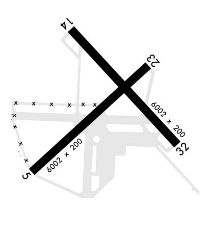
Runway Identifications
Runway Identification: 05/23
Length: 6003 ft
Width: 200 ft
Surface: ASPHALT-FAIR CONDITION
Edge lights: High Intensity

Treatment: NONE
Weight: PCN 31 /F/A/W/T

 Runway: 05   Runway: 23
Mag heading: 49°Mag heading: 229°
Rwy Slope: .22% UpRwy Slope: -.22% Down
Approach: Approach:
Pattern: Left TrafficPattern: Left Traffic
Markings: Markings:
Marking Condition: FAIRMarking Condition: FAIR
Arresting Dev: Arresting Dev:
Lat & Long: N3042.9  W08702.0Lat. & Long.: N3043.6  W08701.1
Elev: 169.3 ft. MSLElev: 182.6 ft. MSL
TCH: 60 ft. AGLTCH: 52 ft. AGL
Visual Glide Path: 3.00 degreesVisual Glide Path: 3.00 degrees
Displaced Threshold: NoDisplaced Threshold: No
Touchdown Zone: YESTouchdown Zone: YES
Touchdown Elev.: 179.7 feetTouchdown Elev.: 183.0 feet
Visual Glide Slope: 4-Light PAPI on LEFT side of RunwayVisual Glide Slope: 4-Light PAPI on LEFT side of Runway
RVR Equipment: RVR Equipment:
RVV Equipment: NORVV Equipment: NO
Approach Lights: Approach Lights:
REIL: NOREIL: NO
Centerline Lights: NOCenterline Lights: NO
Touchdown lights: NOTouchdown lights: NO
Runway Category: Runway Category:
Declared Distances: Declared Distances:
Runway Identification: 14/32
Length: 6001 ft
Width: 200 ft
Surface: ASPHALT-FAIR CONDITION
Edge lights: High Intensity

Treatment: NONE
Weight: PCN 23 /F/A/W/T

 Runway: 14   Runway: 32
Mag heading: 139°Mag heading: 319°
Rwy Slope: -.66% DownRwy Slope: .66% Up
Approach: ILS/DMEApproach:
Pattern: Left TrafficPattern: Left Traffic
Markings: Markings:
Marking Condition: FAIRMarking Condition: FAIR
Arresting Dev: Arresting Dev:
Lat & Long: N3043.8  W08701.7Lat. & Long.: N3043.1  W08700.9
Elev: 198.8 ft. MSLElev: 159.1 ft. MSL
TCH: 51 ft. AGLTCH: 53 ft. AGL
Visual Glide Path: 3.00 degreesVisual Glide Path: 3.00 degrees
Displaced Threshold: NoDisplaced Threshold: No
Touchdown Zone: YESTouchdown Zone: YES
Touchdown Elev.: 198.8 feetTouchdown Elev.: 181.1 feet
Visual Glide Slope: 4-Light PAPI on LEFT side of RunwayVisual Glide Slope: 4-Light PAPI on LEFT side of Runway
RVR Equipment: RVR Equipment:
RVV Equipment: NORVV Equipment: NO
Approach Lights: MALSR - 1,400 foot medium intensity approach lighting system with runway alignment indicator lightsApproach Lights:
REIL: NOREIL: NO
Centerline Lights: NOCenterline Lights: NO
Touchdown lights: NOTouchdown lights: NO
Runway Category: Runway Category:
Declared Distances: Declared Distances:
C:1/P: