Click here for more info on on SMS!

KNRS

NAVAL REAM FIELD (PVT)
IMPERIAL BEACH
CA
Time Zone: Pacific
Lat: N 3234.0
Long: W 11706.8
Elev: 23
Var: -11
Longest Runway: 4998
Dept. ATIS: 276.2
Arr. ATIS: 276.2
Ground: 285.57
Tower: 120.65

FBO & Flight Services info for KNRS

FBOs: Update your Fuel Prices

U.S. NAVY (PRVT) Fax: N/A
-
ASOSPh: 619-437-9890
-
-
 
If you are an FBO, call 1-203-262-1700 to update your info or email: FltPlan.Advertising@garmin.com
Advertise your FBO on FltPlan.com

Runway & Approach Info for KNRS
Rwy
Length
Land Dist**
Approach*
  Rwy
Length
Land Dist**
Approach*
08
2241x151  2241'          
 
  
26
  2241x151  2241'          
 
09
4998x336  4998'          
 
  
27
  4998x336  4998'          
 
 * only ILS, LOC, LDA, and SDF approaches to a specific runway are shown
** For any Declared Landing Distance Available, please see A/FD or Approach plates
Runway Weight Capability (lbs.) Help
Runway IDSingle WheelDouble WheelDouble Tandem WheelDual Double Wheel
08/26N/AN/AN/AN/A
09/27N/AN/AN/AN/A
These numbers are Advisory and are not limits.   The Airport Manager should have more accurate Weight Limits
Approach Charts
Approaches    
Current Weather/Notams
Customs Information Send updates to Support@FltPlan.com
Customs Not Available
Database effective 04/18/2024
Airport Diagram of KNRS
Airport Diagram might not be current.

Facility Name: IMPERIAL BEACH NOLF (REAM FLD)
City Name: IMPERIAL BEACH
County: SAN DIEGO
State abbrev: CA
State Name: CALIFORNIA
   
Ownership: NAVY OWNED
Use: PRIVATE
Owner's Name: US NAVY
Address: OCEANOGRAPHIC OFC - CODE 3142
 WASHINGTON, DC 20373
Owner's Phone:
  
Manager's Name:
Address:
 
Phone:
   
FAA Region: WESTERN-PACIFIC
FAA Field Office: LAX


Sunrise / Sunset times for IMPERIAL BEACH NOLF (REAM FLD)

DateSunriseSunset
04/18/24 Thursday6:1519:21
04/19/24 Friday6:1319:22
04/20/24 Saturday6:1219:23
04/21/24 Sunday6:1119:23
04/22/24 Monday6:1019:24
04/23/24 Tuesday6:0919:25
04/24/24 Wednesday6:0819:25
04/25/24 Thursday6:0719:26
04/26/24 Friday6:0619:27
04/27/24 Saturday6:0519:28
04/28/24 Sunday6:0419:28
04/29/24 Monday6:0319:29
04/30/24 Tuesday6:0219:30
05/01/24 Wednesday6:0119:31

Airport Facilities

Airport Attendance ScheduleOPR 1600-0630Z MON-THU (1500-0600Z DT) AND 1600-0200Z++ FRI. CLSD FR 0200Z++ DAY PRIOR TIL 1600Z++ DAY FLW GOVT HOL; EXC PRE-COORD FLT OF OPR NECESSITY. CTC NOLF ATC DSN 577-9414/9415 FOR OPR INQUIRIES.
Airport Status OPERATIONAL (This Status can change at any time - please check NOTAMS)
Airport Lighting ScheduleAVBL ONLY DURING HRS OF OPERATION.
Airport Storage AvailableNONE
Extra Services AvailableNONE
Wind IndicatorNONE
Control TowerYES
CTAF Frequency
Unicom Frequency
Rotating Beacon ColorSWG
Segmented CircleNO
Landing Fee

Airport Inspection Data

Airport InspectedNo Inspection Data Available performed by the OWNER
Inspection DateUnknown

Airport Services

Type of Fuel AvailableNone
Airframe Repair ServiceNone
Power Plant Repair ServiceNone

Geographic Data

LatitudeN3234.0
LongitudeW11706.8 (ESTIMATED)
Arpt Elevation23ft (SURVEYED)
Magnetic Variation11E
1 miles Sof IMPERIAL BEACH
Traffic Pattern Altitude
Sectional ChartLOS ANGELES

Aircraft Data

Operations (Reported)YearlyAvg. Daily
General Aviation Transient 00
General Aviation Local 00
Air Taxi 00
Commerical 00
Commuter 00
Military 00
Aircraft based on Field
General Aviation Singles 0
General Aviation Multi 0
Jet Aircraft 0
General Aviation Helicopters 0
Military Aircraft 0
Gliders 0
Ultralights 0

FAA Services

FSS on field NO
FSS tie-in SAN DIEGO; FSS-SAN DIEGO SAN-NOTAM NRS
FSS Phone 1-800-WX-BRIEF
Who issues Notams SAN
Notam D service at airport YES
ARTCC Name LOS ANGELES

Federal Status

Airport Certification
Aircraft Rescue & Firefighting IndexNone
Airport of EntryNo
Custom Landing RightsNo
Joint Civil/MilitaryNo
Military Landing rightsNo

Remarks

RSTD - OFFL BUS ONLY - PPR F/W AND NON-TENANT ACFT, CTC NASNI ODO DSN 735-8233/8234, C619-545-8233/8234. NORTH ISLAND TENANT ACFT AND COAST GUARD HAVE PRIORITY FOR LCL PAT OPR.
CAUTION: EXTV COPTER TRNG.
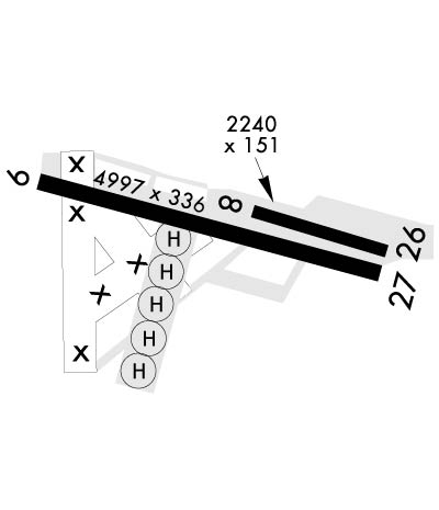
MISC: RWY 08-26 AVBL FOR DAY AND NGT COPTER USE ONLY (NGT AND SVFR USE AT PILOTS OWN RISK).
FUEL: J5 (AVAILABLE 1100-2100 MON-THU; 1000-1800 FRI).
FOR CD WHEN ATCT CLSD CTC SOCAL APCH AT 800-448-3724.
Airport Communications & Frequencies:
ATIS Frequencies:   Hours(local) of Operation: 1600-0630Z MON-THU (1500-0600Z DT) AND 1600-0200Z++ FRI. CLSD FR 0200Z++ DAY PRIOR TIL 1600Z++ DAY FLW GOVT HOL.
276.2
IMPERIAL BEACH Tower Frequencies:   Hours(local) of operation: 1600-0630Z MON-THU (1500-0600Z DT) AND 1600-0200Z++ FRI. CLSD FR 0200Z++ DAY PRIOR TIL 1600Z++ DAY FLW GOVT HOL.   
120.65
239.25
IMPERIAL BEACH Ground Frequencies:
285.575
Emergency Frequencies:
243.0
Remarks
  • ATCT/GCA/ATIS OPR PUBLISHED HRS EXC PRE-COORD FLT OF OPR NECESSITY.
  • SOCAL Primary Approach Frequencies:  
    125.15
    317.55
    SOCAL Primary Departure Frequencies:  
    125.15
    317.55
    Class B Frequencies:
    125.15 110-224 SAN 17,000 FT& BLW
    317.55 110-224 SAN 17,000 FT & BLW
    Runway Identifications
    Runway Identification: 08/26
    Length: 2241 ft
    Width: 151 ft
    Surface: CONCRETE
    Edge lights:

    Treatment: NONE
    Weight: PCN 6 /R/C/W/T

     Runway: 08   Runway: 26
    Mag heading: N/AMag heading: N/A
    Rwy Slope: -.10% DownRwy Slope: .10% Up
    Approach: Approach:
    Pattern: Left TrafficPattern: Left Traffic
    Markings: Markings:
    Marking Condition: Marking Condition:
    Arresting Dev: Arresting Dev:
    Lat & Long: N3234.0  W11706.8Lat. & Long.: N3233.9  W11706.4
    Elev: 23.2 ft. MSLElev: 20.9 ft. MSL
    TCH: TCH:
    Visual Glide Path: Visual Glide Path:
    Displaced Threshold: NoDisplaced Threshold: No
    Touchdown Zone: YESTouchdown Zone: YES
    Touchdown Elev.: 23.2 feetTouchdown Elev.: 23.2 feet
    Visual Glide Slope: Visual Glide Slope:
    RVR Equipment: RVR Equipment:
    RVV Equipment: NORVV Equipment: NO
    Approach Lights: Approach Lights:
    REIL: NOREIL: NO
    Centerline Lights: NOCenterline Lights: NO
    Touchdown lights: NOTouchdown lights: NO
    Runway Category: Runway Category:
    Declared Distances: Declared Distances:
    Runway Identification: 09/27
    Length: 4998 ft
    Width: 336 ft
    Surface:
    Edge lights: High Intensity

    Treatment: NONE
    Weight: PCN 8 /F/A/W/T

     Runway: 09   Runway: 27
    Mag heading: N/AMag heading: N/A
    Rwy Slope: .23% UpRwy Slope: -.23% Down
    Approach: Approach:
    Pattern: Left TrafficPattern: Left Traffic
    Markings: Markings:
    Marking Condition: Marking Condition:
    Arresting Dev: Arresting Dev:
    Lat & Long: N3234.1  W11707.4Lat. & Long.: N3233.9  W11706.4
    Elev: 7.8 ft. MSLElev: 19.5 ft. MSL
    TCH: TCH:
    Visual Glide Path: Visual Glide Path:
    Displaced Threshold: NoDisplaced Threshold: No
    Touchdown Zone: YESTouchdown Zone: YES
    Touchdown Elev.: 22.8 feetTouchdown Elev.: 22.8 feet
    Visual Glide Slope: Visual Glide Slope:
    RVR Equipment: RVR Equipment:
    RVV Equipment: NORVV Equipment: NO
    Approach Lights: Approach Lights:
    REIL: NOREIL: NO
    Centerline Lights: NOCenterline Lights: NO
    Touchdown lights: NOTouchdown lights: NO
    Runway Category: Runway Category:
    Declared Distances: Declared Distances:
    C:/P: