Current Weather/Notams (Metars, TAFs, Notams, NWS Forecast, PIREPS, and nearby weather)
Customs Information Send updates to Support@FltPlan.com
Customs Not Available
Database effective 04/18/2024
Airport Diagram might not be current.
|
| Facility Name: | NORTON MUNI |
| City Name: | NORTON |
| County: | NORTON |
| State abbrev: | KS |
| State Name: | KANSAS |
| | |
| Ownership: | PUBLICLY OWNED |
| Use: | OPEN TO THE PUBLIC |
| Owner's Name: | CITY & COUNTY OF NORTON |
| Address: | 301 EAST WASHINGTON |
| | NORTON, KS 67654 |
| Owner's Phone: | 785-877-5000 |
| | |
| Manager's Name: | BRICE RILEY; DJMILLER@RURALTEL.NET |
| Address: | PO BOX 272 |
| | NORTON, KS 67654 |
| Phone: | 785-877-2201 |
| | |
| FAA Region: | CENTRAL |
| FAA Field Office: | NONE |
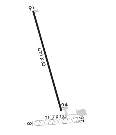
Runway Identifications
Runway Identification: 08/26Length: 2117 ft
Width: 125 ft
Surface: GRASS-FAIR CONDITION
Edge lights: Treatment: NONE
| | Runway: 08 | | Runway: 26 |
| Mag heading: | 84° | Mag heading: | 264° |
| Rwy Slope: | .16% Up | Rwy Slope: | -.16% Down |
| Approach: | | Approach: | |
| Pattern: | Left Traffic | Pattern: | Left Traffic |
| Markings: | | Markings: | |
| Marking Condition: | | Marking Condition: | |
| Arresting Dev: | | Arresting Dev: | |
| Lat & Long: | N3950.8 W09953.9 | Lat. & Long.: | N3950.7 W09953.4 |
| Elev: | 2348.6 ft. MSL | Elev: | 2352.0 ft. MSL |
| TCH: | | TCH: | |
| Visual Glide Path: | | Visual Glide Path: | |
| Displaced Threshold: | No | Displaced Threshold: | No |
| Touchdown Zone: | YES | Touchdown Zone: | YES |
| Touchdown Elev.: | 2362.9 feet | Touchdown Elev.: | 2362.9 feet |
| Visual Glide Slope: | | Visual Glide Slope: | |
| RVR Equipment: | | RVR Equipment: | |
| RVV Equipment: | NO | RVV Equipment: | NO |
| Approach Lights: | | Approach Lights: | |
| REIL: | NO | REIL: | NO |
| Centerline Lights: | NO | Centerline Lights: | NO |
| Touchdown lights: | NO | Touchdown lights: | NO |
| Runway Category: | Runway with a Visual Approach | Runway Category: | Runway with a Visual Approach |
| Declared Distances: | | Declared Distances: | |
| Obstructions: | TREE | Obstructions: | TREES |
| Marked: | NOT Marked/Lighted | Marked: | NOT Marked/Lighted |
| Clearance slope: | 43:1 | Clearance slope: | 19:1; AER 26 UNMARKED. |
| Obstruction height: | 39 feet AGL | Obstruction height: | 40 feet AGL |
| Dist. from runway: | 1650 feet | Dist. from runway: | 734 feet |
| Centerline offset: | 144 left of centerline | Centerline offset: | 127B |
| Comments: | | Comments: | |
Runway Identification: 16/34Length: 4701 ft
Width: 60 ft
Surface: CONCRETE
Edge lights: High IntensityTreatment: NONE
| | Runway: 16 | | Runway: 34 |
| Mag heading: | 157° | Mag heading: | 337° |
| Rwy Slope: | -.47% Down | Rwy Slope: | .47% Up |
| Approach: | | Approach: | |
| Pattern: | Left Traffic | Pattern: | Left Traffic |
| Markings: | NONPRECISION INSTRUMENT | Markings: | NONPRECISION INSTRUMENT |
| Marking Condition: | GOOD | Marking Condition: | GOOD |
| Arresting Dev: | | Arresting Dev: | |
| Lat & Long: | N3951.5 W09953.8 | Lat. & Long.: | N3950.8 W09953.6 |
| Elev: | 2384.0 ft. MSL | Elev: | 2361.9 ft. MSL |
| TCH: | 44 ft. AGL | TCH: | 43 ft. AGL |
| Visual Glide Path: | 3.00 degrees | Visual Glide Path: | 3.00 degrees |
| Displaced Threshold: | No | Displaced Threshold: | No |
| Touchdown Zone: | YES | Touchdown Zone: | YES |
| Touchdown Elev.: | 2384.0 feet | Touchdown Elev.: | 2375.7 feet |
| Visual Glide Slope: | 2-Light PAPI on LEFT side of Runway | Visual Glide Slope: | 2-Light PAPI on LEFT side of Runway |
| RVR Equipment: | | RVR Equipment: | |
| RVV Equipment: | NO | RVV Equipment: | NO |
| Approach Lights: | | Approach Lights: | |
| REIL: | NO | REIL: | NO |
| Centerline Lights: | NO | Centerline Lights: | NO |
| Touchdown lights: | NO | Touchdown lights: | NO |
| Runway Category: | Runway with a Non-precision Approach having visibility minimums greater than 3/4 mile | Runway Category: | Runway with a Non-precision Approach having visibility minimums greater than 3/4 mile |
| Declared Distances: | | Declared Distances: | |
