Click here for more info on on SMS!

KNQI

KINGSVILLE NAS (PRIVATE)
KINGSVILLE
TX
Time Zone: Central
Lat: N 2730.3
Long: W 09748.5
Elev: 50
Var: -04
Longest Runway: 8001
Clr Del: 328.4
Dept. ATIS: 276.2
Arr. ATIS: 276.2
Ground: 239.05
Tower: 124.1

FBO & Flight Services info for KNQI

FBOs: Update your Fuel Prices

PRIVATE - U.S.N.Ph: 361-876-6108
-
-

BASE OPSPh: -
-
Freq: 274.8

If you are an FBO, call 1-203-262-1700 to update your info or email: FltPlan.Advertising@garmin.com
Advertise your FBO on FltPlan.com

Runway & Approach Info for KNQI
Rwy
Length
Land Dist**
Approach*
  Rwy
Length
Land Dist**
Approach*
13L
8000x198  8000'          
 
  
31R
  8000x198  8000'          
 
13R
8000x198  8000'          
ILS/DME
 110.90 - 130°  
  
31L
  8000x198  8000'          
 
17L
8001x197  8001'          
 
  
35R
  8001x197  8001'          
 
17R
8000x198  8000'          
 
  
35L
  8000x198  8000'          
 
 * only ILS, LOC, LDA, and SDF approaches to a specific runway are shown
** For any Declared Landing Distance Available, please see A/FD or Approach plates
Runway Weight Capability (lbs.) Help
Runway IDSingle WheelDouble WheelDouble Tandem WheelDual Double Wheel
13L/31RN/AN/AN/AN/A
13R/31LN/AN/AN/AN/A
17L/35RN/AN/AN/AN/A
17R/35LN/AN/AN/AN/A
These numbers are Advisory and are not limits.   The Airport Manager should have more accurate Weight Limits
Approach Charts
Approaches    
Current Weather/Notams
Customs Information Send updates to Support@FltPlan.com
Customs Not Available
Database effective 04/18/2024
Airport Diagram of KNQI
Airport Diagram might not be current.

Facility Name: KINGSVILLE NAS
City Name: KINGSVILLE
County: KLEBERG
State abbrev: TX
State Name: TEXAS
   
Ownership: NAVY OWNED
Use: PRIVATE
Owner's Name: U S NAVY
Address: OCEANOGRAPHIC OFC-CODE 3142
 WASHINGTON, DC 20373
Owner's Phone:
  
Manager's Name: COMMANDING OFFICER
Address: NAVAL AIR STATION
 KINGSVILLE, TX 78363
Phone: 361-516-4331
   
FAA Region: SOUTHWEST
FAA Field Office: TEX


Sunrise / Sunset times for KINGSVILLE NAS

DateSunriseSunset
04/15/24 Monday7:0619:57
04/16/24 Tuesday7:0519:57
04/17/24 Wednesday7:0419:58
04/18/24 Thursday7:0319:58
04/19/24 Friday7:0219:59
04/20/24 Saturday7:0119:59
04/21/24 Sunday7:0020:00
04/22/24 Monday6:5920:00
04/23/24 Tuesday6:5820:01
04/24/24 Wednesday6:5720:01
04/25/24 Thursday6:5620:02
04/26/24 Friday6:5620:03
04/27/24 Saturday6:5520:03
04/28/24 Sunday6:5420:04

Airport Facilities

Airport Attendance ScheduleMON-THU 1345-0600Z++, FRI 1345-2345Z++; CLSD SAT, SUN AND FED HOL EXC BY NOTAM. HRS SUBJECT TO CHG. FLD SUBJ EARLY/NO NOTICE CLOSURE.
Airport Status OPERATIONAL (This Status can change at any time - please check NOTAMS)
Airport Lighting ScheduleAVBL ONLY DURG HRS OF OPN.
Airport Storage AvailableNONE
Extra Services AvailableNONE
Wind IndicatorNONE
Control TowerYES
CTAF Frequency
Unicom Frequency
Rotating Beacon ColorSWG
Segmented CircleNO
Landing Fee

Airport Inspection Data

Airport InspectedNo Inspection Data Available performed by the OWNER
Inspection DateUnknown

Airport Services

Type of Fuel AvailableNone
Airframe Repair ServiceNone
Power Plant Repair ServiceNone

Geographic Data

LatitudeN2730.3
LongitudeW09748.5 (ESTIMATED)
Arpt Elevation50ft (SURVEYED)
Magnetic Variation04E
3 miles Eof KINGSVILLE
Traffic Pattern Altitude
Sectional ChartBROWNSVILLE

Aircraft Data

Operations (Reported)YearlyAvg. Daily
General Aviation Transient 00
General Aviation Local 00
Air Taxi 00
Commerical 00
Commuter 00
Military 00
Aircraft based on Field
General Aviation Singles 0
General Aviation Multi 0
Jet Aircraft 0
General Aviation Helicopters 0
Military Aircraft 0
Gliders 0
Ultralights 0

FAA Services

FSS on field NO
FSS tie-in SAN ANGELO
FSS Phone 1-800-WX-BRIEF
Who issues Notams SJT
Notam D service at airport YES
ARTCC Name HOUSTON

Federal Status

Airport Certification
Aircraft Rescue & Firefighting IndexNone
Airport of EntryNo
Custom Landing RightsNo
Joint Civil/MilitaryNo
Military Landing rightsNo

Remarks

CAUTION: HVY JET INST TRNG DUR FLD OPR HR.
BEARING STRENGTH RWY 13R/31L: ST175 SBTT593 TRT585.
BEARING STRENGTH RWY 17R/35L: ST175 SBTT593 TRT585.
BEARING STRENGTH RWY 17L/35R: ST175 SBTT593 TRT585.
SERVICE - LGT: OLS GS 3.25DEG.
JASU: 1(NC-10) 1(GTC-85).
FUEL: JAA.
FLUID: SP PRESAIR LOX.
OIL: O-148-156.
TRAN ALERT: EXPC SVCG DLAS WKEND. SVC NOT AVBL SUN TIL 2300Z++. TRAN CREW IS RESPONSIBLE FOR FUELING ACFT. DRAG CHUTE REPACK UNAVBL.
CAUTION: BIRD AND LARGE WILDLIFE HAZARD.
TRAN ACFT CTC APP CON 25 NM OUT.
CAUTION: AVOID OVFT OF CHEMICAL PLANT 5 NM N.
CAT C AFLD.
TFC PAT: ARR TSNT ACFT EXP ENR DESCENT.
TFC PAT: USE LDG/TAXI LGT FOR FINAL PORTION OF INST APCH DURG VFR.
RSTD: PPR FOR NON-CNATRA ACFT CTC BASE OPS DURG FLD OPR HR DSN 876-6108, C361-516-6108. FOR CALP PROCESSING CTC AFLD MGR VIA BASE OPS.
MISC: DURG FCLP PERIODS OR SINGLE RWY OPNS PRACTICE APCHS FOR TRANS ACFT MAY BE DENIED. PRACTICE APCHS FOR TRANS ACFT MAY BE PERMITTED AT ALL OTHER TIMES BUT DLYS OR WAVE-OFFS SHOULD BE ANTICIPATED.
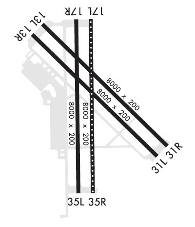
BEARING STRENGTH RWY 13L/31R: ST 175 SBTT593 TRT585.
Airport Communications & Frequencies:
ATIS Frequencies:   Hours(local) of Operation: AVBL 20 MINS PRIOR TO OPR HRS TIL COMPLETION OF OPR HRS OR CLOSURE.
282.25
KINGSVILLE Tower Frequencies:   Hours(local) of operation: 1345-0600Z++ MON-THU 1345-2345Z++ FRI; CLSD SAT, SUN & HOL EXC BY NOTAM. HRS SUBJECT TO CHG.   
124.1
377.05
KINGSVILLE Ground Frequencies:
239.05
Clearance Delivery Frequencies:
328.4
Emergency Frequencies:
121.5
243.0
Remarks
  • APCH/DEP CTL SVC PRVDD BY HOUSTON ARTCC (ZHU) ON FREQS 128.15/350.3 (KINGSVILLE RCAG) WHEN KINGSVILLE APCH CTL (NQI) CLSD.
  • TRANS ACFT CTC APCH CTL 25 NM OUT.
  • PMSV AVBL SUM 1000-0500Z++ MON-THU; 1000-2200Z++ FRI; 2000-0100Z++ SUN. WIN 1000-0500Z++ MON-THU; 1000-2200Z++ FRI; 1930-0100Z++ SUN.
  • KINGSVILLE Primary Approach Frequencies:   Hours(local) of operation: 1345-0600Z++ MON-THU; 1345-2345Z++ FRI; CLSD SAT, SUN AND HOL EXC BY NOTAM, HRS SUBJ TO CHG.   
    119.9
    290.45
    KINGSVILLE Primary Departure Frequencies:   Hours(local) of operation: 1345-0600Z++ MON-THU; 1345-2345Z++ FRI; CLSD SAT, SUN AND HOL EXC BY NOTAM, HRS SUBJ TO CHG.   
    121.05
    266.8
    Runway Identifications
    Runway Identification: 13L/31R
    Length: 8000 ft
    Width: 198 ft
    Surface: -FAIR CONDITION
    Edge lights: High Intensity

    Treatment: NONE
    Weight: PCN 49 /R/C/W/T

     Runway: 13L   Runway: 31R
    Mag heading: 130°Mag heading: 310°
    Rwy Slope: -.14% DownRwy Slope: .14% Up
    Approach: Approach:
    Pattern: Left TrafficPattern: Left Traffic
    Markings: PRECISION INSTRUMENTMarkings: PRECISION INSTRUMENT
    Marking Condition: FAIRMarking Condition: FAIR
    Arresting Dev: E28; HOOK E28(B) (1050').Arresting Dev: E28; HOOK E28(B) (1500').
    Lat & Long: N2730.8  W09748.9Lat. & Long.: N2729.9  W09747.9
    Elev: 48.0 ft. MSLElev: 36.7 ft. MSL
    TCH: TCH: 51 ft. AGL
    Visual Glide Path: Visual Glide Path: 3.00 degrees
    Displaced Threshold: NoDisplaced Threshold: No
    Touchdown Zone: YESTouchdown Zone: YES
    Touchdown Elev.: 48.6 feetTouchdown Elev.: 43.9 feet
    Visual Glide Slope: Visual Glide Slope: 4-Light PAPI on LEFT side of Runway
    RVR Equipment: RVR Equipment:
    RVV Equipment: NORVV Equipment: NO
    Approach Lights: OLS. WAVEOFF.Approach Lights: OLS. WAVEOFF.
    REIL: YESREIL: YES
    Centerline Lights: NOCenterline Lights: NO
    Touchdown lights: NOTouchdown lights: NO
    Runway Category: Runway Category:
    Declared Distances: Declared Distances:
    Runway Identification: 13R/31L
    Length: 8000 ft
    Width: 198 ft
    Surface: -FAIR CONDITION
    Edge lights: High Intensity

    Treatment: NONE
    Weight: PCN 48 /R/C/W/T

     Runway: 13R   Runway: 31L
    Mag heading: 130°Mag heading: 310°
    Rwy Slope: -.11% DownRwy Slope: .11% Up
    Approach: ILS/DMEApproach:
    Pattern: Left TrafficPattern: Left Traffic
    Markings: PRECISION INSTRUMENTMarkings: PRECISION INSTRUMENT
    Marking Condition: FAIRMarking Condition: FAIR
    Arresting Dev: E28; HOOK E28(B) (1550').Arresting Dev: E28; HOOK E28(B) (1503').
    Lat & Long: N2730.8  W09749.0Lat. & Long.: N2729.8  W09747.9
    Elev: 49.5 ft. MSLElev: 41.1 ft. MSL
    TCH: 34 ft. AGLTCH:
    Visual Glide Path: 3.00 degreesVisual Glide Path:
    Displaced Threshold: NoDisplaced Threshold: No
    Touchdown Zone: YESTouchdown Zone: YES
    Touchdown Elev.: 49.7 feetTouchdown Elev.: 47.2 feet
    Visual Glide Slope: 4-Light PAPI on LEFT side of RunwayVisual Glide Slope:
    RVR Equipment: RVR Equipment:
    RVV Equipment: NORVV Equipment: NO
    Approach Lights: OLS. WAVEOFF.Approach Lights: OLS. WAVEOFF.
    REIL: YESREIL: YES
    Centerline Lights: NOCenterline Lights: NO
    Touchdown lights: NOTouchdown lights: NO
    Runway Category: Runway Category:
    Declared Distances: Declared Distances:
    Runway Identification: 17L/35R
    Length: 8001 ft
    Width: 197 ft
    Surface: -GOOD CONDITION
    Edge lights: High Intensity

    Treatment: NONE
    Weight: PCN 60 /R/C/W/T

     Runway: 17L   Runway: 35R
    Mag heading: 175°Mag heading: 355°
    Rwy Slope: -.02% DownRwy Slope: .02% Up
    Approach: Approach:
    Pattern: Left TrafficPattern: Left Traffic
    Markings: PRECISION INSTRUMENTMarkings: PRECISION INSTRUMENT
    Marking Condition: GOODMarking Condition: GOOD
    Arresting Dev: E28; HOOK E28(B) (1675').Arresting Dev: E28; HOOK E28(B) (1516').
    Lat & Long: N2730.9  W09748.5Lat. & Long.: N2729.5  W09748.5
    Elev: 47.9 ft. MSLElev: 46.5 ft. MSL
    TCH: TCH: 51 ft. AGL
    Visual Glide Path: Visual Glide Path: 3.00 degrees
    Displaced Threshold: NoDisplaced Threshold: No
    Touchdown Zone: YESTouchdown Zone: YES
    Touchdown Elev.: 49.0 feetTouchdown Elev.: 47.8 feet
    Visual Glide Slope: Visual Glide Slope: 4-Light PAPI on LEFT side of Runway
    RVR Equipment: RVR Equipment:
    RVV Equipment: NORVV Equipment: NO
    Approach Lights: OLS. WAVEOFF TDZL.Approach Lights: ALSF1 - standard 2,400 foot high intensity approach lighting system with sequenced flashers, Category I; OLS. WAVEOFF.
    REIL: YESREIL: YES
    Centerline Lights: YESCenterline Lights: YES
    Touchdown lights: NOTouchdown lights: NO
    Runway Category: Runway Category:
    Declared Distances: Declared Distances:
    Runway Identification: 17R/35L
    Length: 8000 ft
    Width: 198 ft
    Surface: -FAIR CONDITION
    Edge lights: High Intensity

    Treatment: NONE
    Weight: PCN 56 /R/C/W/T

     Runway: 17R   Runway: 35L
    Mag heading: 175°Mag heading: 355°
    Rwy Slope: .00% DownRwy Slope: .00% Up
    Approach: Approach:
    Pattern: Left TrafficPattern: Left Traffic
    Markings: PRECISION INSTRUMENTMarkings: PRECISION INSTRUMENT
    Marking Condition: FAIRMarking Condition: FAIR
    Arresting Dev: E28; HOOK E28(B) (1250').Arresting Dev: E28; HOOK E28(B) (1600').
    Lat & Long: N2730.9  W09748.6Lat. & Long.: N2729.5  W09748.6
    Elev: 48.0 ft. MSLElev: 47.6 ft. MSL
    TCH: 51 ft. AGLTCH:
    Visual Glide Path: 3.00 degreesVisual Glide Path:
    Displaced Threshold: NoDisplaced Threshold: No
    Touchdown Zone: YESTouchdown Zone: YES
    Touchdown Elev.: 49.3 feetTouchdown Elev.: 48.3 feet
    Visual Glide Slope: 4-Light PAPI on LEFT side of RunwayVisual Glide Slope:
    RVR Equipment: RVR Equipment:
    RVV Equipment: NORVV Equipment: NO
    Approach Lights: OLS. WAVEOFF.Approach Lights: OLS. WAVEOFF.
    REIL: YESREIL: YES
    Centerline Lights: NOCenterline Lights: NO
    Touchdown lights: NOTouchdown lights: NO
    Runway Category: Runway Category:
    Declared Distances: Declared Distances:
    C:/P: