Click here for more info on on SMS!

KNOG

ORANGE GROVE NALF (PRIVATE)
ORANGE GROVE
TX
Time Zone: Central
Lat: N 2753.8
Long: W 09802.6
Elev: 257
Var: -05
Longest Runway: 8001
Clr Del: 229.4
Dept. ATIS: 254.35
Arr. ATIS: 254.35
Ground: 229.4
Tower: 128.4

FBO & Flight Services info for KNOG

FBOs: Update your Fuel Prices

U.S. NAVY (PVT)Ph: 361-876-6108
-
-
If you are an FBO, call 1-203-262-1700 to update your info or email: FltPlan.Advertising@garmin.com
Advertise your FBO on FltPlan.com

Runway & Approach Info for KNOG
Rwy
Length
Land Dist**
Approach*
  Rwy
Length
Land Dist**
Approach*
01
8000x198  8000'          
 
  
19
  8000x198  8000'          
 
13
8001x198  8001'          
ILS/DME
 110.50 - 129°  
  
31
  8001x198  8001'          
 
 * only ILS, LOC, LDA, and SDF approaches to a specific runway are shown
** For any Declared Landing Distance Available, please see A/FD or Approach plates
Runway Weight Capability (lbs.) Help
Runway IDSingle WheelDouble WheelDouble Tandem WheelDual Double Wheel
01/19N/AN/AN/AN/A
13/31N/AN/AN/AN/A
These numbers are Advisory and are not limits.   The Airport Manager should have more accurate Weight Limits
Approach Charts
Approaches    
Current Weather/Notams
Customs Information Send updates to Support@FltPlan.com
Customs Not Available
Database effective 05/16/2024
Airport Diagram of KNOG
Airport Diagram might not be current.

Facility Name: ORANGE GROVE NALF
City Name: ORANGE GROVE
County: JIM WELLS
State abbrev: TX
State Name: TEXAS
   
Ownership: NAVY OWNED
Use: PRIVATE
Owner's Name: US NAVY
Address: OCEANOGRAPHIC OFC - CODE 3142
 WASHINGTON, DC 20373
Owner's Phone:
  
Manager's Name:
Address:
 
Phone:
   
FAA Region: SOUTHWEST
FAA Field Office: TEX


Sunrise / Sunset times for ORANGE GROVE NALF

DateSunriseSunset
04/24/24 Wednesday6:5820:03
04/25/24 Thursday6:5720:03
04/26/24 Friday6:5620:04
04/27/24 Saturday6:5520:05
04/28/24 Sunday6:5420:05
04/29/24 Monday6:5320:06
04/30/24 Tuesday6:5320:06
05/01/24 Wednesday6:5220:07
05/02/24 Thursday6:5120:08
05/03/24 Friday6:5020:08
05/04/24 Saturday6:4920:09
05/05/24 Sunday6:4920:09
05/06/24 Monday6:4820:10
05/07/24 Tuesday6:4720:10

Airport Facilities

Airport Attendance ScheduleALL; OPR HRS BY NOTAM IN SUPPORT OF TRAWING-2 FLT OPR.
Airport Status OPERATIONAL (This Status can change at any time - please check NOTAMS)
Airport Lighting ScheduleAVBL ONLY DURING HRS OF OPERATION.
Airport Storage AvailableNONE
Extra Services AvailableNONE
Wind IndicatorNONE
Control TowerYES
CTAF Frequency
Unicom Frequency
Rotating Beacon ColorSWG
Segmented CircleNO
Landing Fee

Airport Inspection Data

Airport InspectedNo Inspection Data Available performed by the OWNER
Inspection DateUnknown

Airport Services

Type of Fuel AvailableNone
Airframe Repair ServiceNone
Power Plant Repair ServiceNone

Geographic Data

LatitudeN2753.8
LongitudeW09802.6 (ESTIMATED)
Arpt Elevation257ft (SURVEYED)
Magnetic Variation05E
8 miles Nof ORANGE GROVE
Traffic Pattern Altitude
Sectional ChartBROWNSVILLE

Aircraft Data

Operations (Reported)YearlyAvg. Daily
General Aviation Transient 00
General Aviation Local 00
Air Taxi 00
Commerical 00
Commuter 00
Military 00
Aircraft based on Field
General Aviation Singles 0
General Aviation Multi 0
Jet Aircraft 0
General Aviation Helicopters 0
Military Aircraft 0
Gliders 0
Ultralights 0

FAA Services

FSS on field NO
FSS tie-in SAN ANGELO
FSS Phone 1-800-WX-BRIEF
Who issues Notams SJT
Notam D service at airport YES
ARTCC Name HOUSTON

Federal Status

Airport Certification
Aircraft Rescue & Firefighting IndexNone
Airport of EntryNo
Custom Landing RightsNo
Joint Civil/MilitaryNo
Military Landing rightsNo

Remarks

CAUTION: STUDENT JET TRNG IN VCNTY DUR OPR HR.
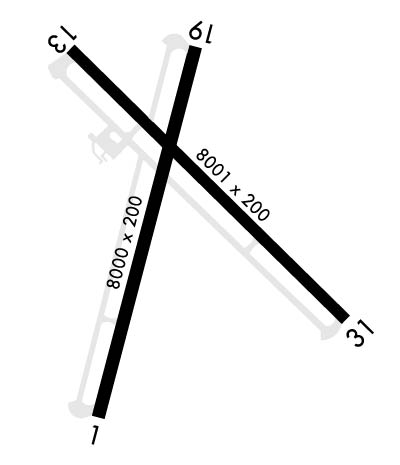
RWY-LGTS: RWY 01 - OLS. RWY 19 - OLS.
RWY-LGTS: RWY 13 - OLS. RWY 31 - OLS.
SERVICE-LGT: OLS GS 3.25DEG.
CAUTION: BIRD AND LARGE WILDLIFE HAZARD.
JET BREAK ALT 1300 FT MSL. USE LDG/TAXI LGT ON FINAL APCH DUR VFR COND.
RSTD: CNATRA USE ONLY EXC IN EMERG, NALF ADMIN DSN 876-6140, NAS KINGSVILLE BASE OPS DSN 876-6108.
TRAN ALERT: NO TRAN MAINT OR SVC AVBL. REFUEL CNATRA ACFT ONLY.
BEARING STRENGTH RWY 13/31: ST119 SBTT320 TRT306.
FUEL: JAA.
FLUID: SP PRESAIR.
OIL: O-156.
Airport Communications & Frequencies:
ATIS Frequencies:   Hours(local) of Operation: 1330-2130Z++ MON-THU; 1330-1930Z++ FRI
254.35
NAVY ORANGE Tower Frequencies:   Hours(local) of operation: 1330-2130Z++ MON-FRI; CLSD SAT, SUN AND HOL BY NOTAM; HRS SUBJECT TO CHG IN SUPPORT OF TRAWING-2 FLT OPR.   
128.4
281.425
318.85
NAVY ORANGE Ground Frequencies:
229.4
Clearance Delivery Frequencies:
229.4
Remarks
  • APCH/DEP CTL SVC PRVDD BY HOUSTON ARTCC (ZHU) ON FREQS 128.15/350.3 (KINGSVILLE RCAG) WHEN KINGSVILLE APCH CTL (NQI) CLSD.
  • FREQ 318.85 LDG SIGNAL OFFICER
  • KINGSVILLE Primary Approach Frequencies:  
    119.9
    290.45
    KINGSVILLE Primary Departure Frequencies:  
    119.9
    290.45
    Runway Identifications
    Runway Identification: 01/19
    Length: 8000 ft
    Width: 198 ft
    Surface: -FAIR CONDITION
    Edge lights: Medium Intensity

    Treatment: NONE
    Weight: PCN 25 /R/C/W/T

     Runway: 01   Runway: 19
    Mag heading: 10°Mag heading: 190°
    Rwy Slope: .14% UpRwy Slope: -.14% Down
    Approach: Approach:
    Pattern: Left TrafficPattern: Left Traffic
    Markings: PRECISION INSTRUMENTMarkings: PRECISION INSTRUMENT
    Marking Condition: FAIRMarking Condition: FAIR
    Arresting Dev: E28; HOOK E28(B) (1500').Arresting Dev: E28; HOOK E28(B) (1500').
    Lat & Long: N2753.1  W09802.9Lat. & Long.: N2754.4  W09802.5
    Elev: 229.6 ft. MSLElev: 240.8 ft. MSL
    TCH: TCH:
    Visual Glide Path: Visual Glide Path:
    Displaced Threshold: NoDisplaced Threshold: No
    Touchdown Zone: YESTouchdown Zone: YES
    Touchdown Elev.: 239.0 feetTouchdown Elev.: 243.0 feet
    Visual Glide Slope: Visual Glide Slope:
    RVR Equipment: RVR Equipment:
    RVV Equipment: NORVV Equipment: NO
    Approach Lights: Approach Lights:
    REIL: NOREIL: NO
    Centerline Lights: NOCenterline Lights: NO
    Touchdown lights: NOTouchdown lights: NO
    Runway Category: Runway Category:
    Declared Distances: Declared Distances:
    Runway Identification: 13/31
    Length: 8001 ft
    Width: 198 ft
    Surface: -FAIR CONDITION
    Edge lights: Medium Intensity

    Treatment: NONE
    Weight: PCN 19 /R/C/W/T

     Runway: 13   Runway: 31
    Mag heading: 130°Mag heading: 310°
    Rwy Slope: -.41% DownRwy Slope: .41% Up
    Approach: ILS/DMEApproach:
    Pattern: Left TrafficPattern: Left Traffic
    Markings: PRECISION INSTRUMENTMarkings: PRECISION INSTRUMENT
    Marking Condition: FAIRMarking Condition: FAIR
    Arresting Dev: E28; HOOK E28(B) (1500').Arresting Dev: E28; HOOK E28(B) (1501').
    Lat & Long: N2754.4  W09803.0Lat. & Long.: N2753.4  W09802.0
    Elev: 257.2 ft. MSLElev: 224.3 ft. MSL
    TCH: TCH:
    Visual Glide Path: Visual Glide Path:
    Displaced Threshold: NoDisplaced Threshold: No
    Touchdown Zone: YESTouchdown Zone: YES
    Touchdown Elev.: 257.2 feetTouchdown Elev.: 232.4 feet
    Visual Glide Slope: Visual Glide Slope:
    RVR Equipment: RVR Equipment:
    RVV Equipment: NORVV Equipment: NO
    Approach Lights: Approach Lights:
    REIL: NOREIL: NO
    Centerline Lights: NOCenterline Lights: NO
    Touchdown lights: NOTouchdown lights: NO
    Runway Category: Runway Category:
    Declared Distances: Declared Distances:
    C:/P: