Click here for more info on on SMS!

KNKT

CHERRY POINT MCAS /CUNNINGHAM
CHERRY POINT
NC
Time Zone: Eastern
Lat: N 3454.2
Long: W 07652.8
Elev: 29
Var: +09
Longest Runway: 8978
Clr Del: 125.95
Dept. ATIS: 127.47
Arr. ATIS: 127.47
Ground: 128.62
Tower: 121.3

FBO & Flight Services info for KNKT

FBOs: Update your Fuel Prices

PRIVATE U.S. NAVY Fax: N/A
-

If you are an FBO, call 1-203-262-1700 to update your info or email: FltPlan.Advertising@garmin.com
Advertise your FBO on FltPlan.com

Runway & Approach Info for KNKT
Rwy
Length
Land Dist**
Approach*
  Rwy
Length
Land Dist**
Approach*
05L
8489x196  7554'          
 
  
23R
  8489x196  8489'          
ILS/DME
 108.90 - 234°  
05R
8189x200  8189'          
 
  
23L
  8189x200  8189'          
 
14L
8978x200  8978'          
 
  
32R
  8978x200  8978'          
 
14R
8397x200  7549'          
 
  
32L
  8397x200  8397'          
 
 * only ILS, LOC, LDA, and SDF approaches to a specific runway are shown
** For any Declared Landing Distance Available, please see A/FD or Approach plates
Runway Weight Capability (lbs.) Help
Runway IDSingle WheelDouble WheelDouble Tandem WheelDual Double Wheel
05L/23RN/AN/AN/AN/A
05R/23LN/AN/AN/AN/A
14L/32RN/AN/AN/AN/A
14R/32LN/AN/AN/AN/A
These numbers are Advisory and are not limits.   The Airport Manager should have more accurate Weight Limits
Approach Charts
Approaches    
Current Weather/Notams
Customs Information Send updates to Support@FltPlan.com
Customs Not Available
Database effective 05/16/2024
Airport Diagram of KNKT
Airport Diagram might not be current.

Facility Name: CHERRY POINT MCAS (CUNNINGHAM FLD)
City Name: CHERRY POINT
County: PAMLICO
State abbrev: NC
State Name: NORTH CAROLINA
   
Ownership: NAVY OWNED
Use: PRIVATE
Owner's Name: US NAVY
Address: OCEANOGRAPHIC OFC-CODE 3142
 WASHINGTON, DC 20373
Owner's Phone:
  
Manager's Name: COMMANDING OFFICER
Address: MARINE CORPS AIR STATION
 CHERRY POINT, NC 28533
Phone: 252-466-2233
   
FAA Region: SOUTHERN
FAA Field Office: MEM


Sunrise / Sunset times for CHERRY POINT MCAS (CUNNINGHAM FLD)

DateSunriseSunset
04/22/24 Monday6:2619:46
04/23/24 Tuesday6:2519:47
04/24/24 Wednesday6:2419:48
04/25/24 Thursday6:2319:49
04/26/24 Friday6:2119:49
04/27/24 Saturday6:2019:50
04/28/24 Sunday6:1919:51
04/29/24 Monday6:1819:52
04/30/24 Tuesday6:1719:53
05/01/24 Wednesday6:1619:53
05/02/24 Thursday6:1519:54
05/03/24 Friday6:1419:55
05/04/24 Saturday6:1319:56
05/05/24 Sunday6:1219:57

Airport Facilities

Airport Attendance ScheduleCONTINUOUS
Airport Status OPERATIONAL (This Status can change at any time - please check NOTAMS)
Airport Lighting ScheduleAVBL ONLY DURING HRS OF OPERATION.
Airport Storage AvailableNONE
Extra Services AvailableNONE
Wind IndicatorNONE
Control TowerYES
CTAF Frequency
Unicom Frequency
Rotating Beacon ColorSWG
Segmented CircleNO
Landing Fee

Airport Inspection Data

Airport InspectedNo Inspection Data Available performed by the OWNER
Inspection DateUnknown

Airport Services

Type of Fuel AvailableGrade 100LLJ5; -10FUEL: HOT PIT RFL AVBL.
Airframe Repair ServiceNone
Power Plant Repair ServiceNone

Geographic Data

LatitudeN3454.2
LongitudeW07652.8 (ESTIMATED)
Arpt Elevation29ft (SURVEYED)
Magnetic Variation09W
2 miles NEof CHERRY POINT
Traffic Pattern AltitudeTPA: 1000 FT AGL, OVHD PAT ALT 1500 FT AGL.
Sectional ChartCHARLOTTE

Aircraft Data

Operations (Reported)YearlyAvg. Daily
General Aviation Transient 00
General Aviation Local 00
Air Taxi 00
Commerical 00
Commuter 00
Military 00
Aircraft based on Field
General Aviation Singles 0
General Aviation Multi 0
Jet Aircraft 0
General Aviation Helicopters 0
Military Aircraft 0
Gliders 0
Ultralights 0

FAA Services

FSS on field NO
FSS tie-in RALEIGH
FSS Phone 1-800-WX-BRIEF
Who issues Notams NKT
Notam D service at airport YES
ARTCC Name WASHINGTON

Federal Status

Airport Certification
Aircraft Rescue & Firefighting IndexNone
Airport of EntryNo
Custom Landing RightsNo
Joint Civil/MilitaryNo
Military Landing rightsNo

Remarks

PPR WKENDS CTC OPNS DUTY OFFICER; V582-3632/5025.
LGT: PORTABLE LGT-MOBILE FLOOD LGT.
A-GEAR: ALL E-28(B) IN RAISED POSN EXC ON LDG RWY. RQR 15 MIN PN.
JASU: 2 WORKING DAYS PN RQR. 2(GTC-85) 1(NCPP-105)
FLUID: SP PRESAIR HPOX LOX DE-ICE.
TRAN ALERT: LTD TRAN MAINT AVBL 1200-2100Z++ MON-FRI. NO LAVATORY SVC AVBL.
SEE FLIP AP/1 SUPPLEMENTARY ARPT
RSTD: MIN 24HR NOTICE PPR ALL TRAN ACFT. CALL BASE OPS DSN 582-2233/4334, C252-466-2233/4334. FLT PLANNING/BASE OPS OPR 24 HR EXCEPT FEDERAL HOLIDAYS, EXP CLOSURE OR REDUCED SVCS PER NOTAM. ALL RWY AND TWY, EXC TWY A AND C, WILL SUPPORT ALL ACFT AT ALL WT.
CAUTION: EXTV STU JET TRNG (V/STOL) VCNTY ARPT. TRAN ACFT EXP STR-IN FULL STOP LDG ONLY DUR PEAK STU TRNG PERIODS. BIRD HAZ OCT-APR. DRAINAGE DITCHES PARL ALL RWY. WILDLIFE HAZ ON ARPT, ESPECIALLY SS-SR. OBST APRX 200 FT NEAR NKT R-205/3.
TFC PAT: LDG/TAXI LGT RQR ALL LDG. REDUCED RWY SEPARATION IN EFF FOR USN/USMC ACFT.
CSTMS/AG/IMG: CSTMS, AG AVBL WITH 24 HR PN. REF FCG FOR DETAILS. ACFT ARR FROM OVERSEAS CTC OPS VIA FONE PATCH 252-466-2233 MIN 2 HR PRIOR TO ARR FOR CSTMS.
MISC: 24 HR PN RQR OF ALL DV CODES, CTC BASE OPS DSN 582-2233, C252-466-2233. ALL ACFT WITH PAX/CARGO/DV MUST CTC PTD 20 MIN PRIOR TO LDG. ATC TERMINOLOGY - CENTERMAT - IS DEFINED AS THE CNTR OF AFLD WHERE THE FOUR TWYS INT, RATED FOR ALL ACFT WHEEL WEIGHTS.
TSNT ALERT: PPR MIN 24 HRS IN ADV. TRAN ACFT WITH INERT ORDNANCE, HOT PIT REFUEL LTD TO F18, USAF F15, F16, AND A10 ACFT ONLY IAW CHERRY POINT AIROPS MAN.
CAUTION: OBSTACLE UNLIT TWR AT NKT200006 549 FT.
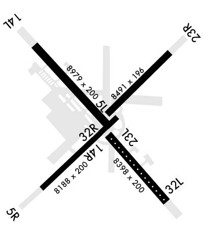
ACFT RESTRICTED FM TAXIING ON TWY K BTN RWY 23R & TEST CELL. TOWING OPERATIONS ONLY.
MIN 24 HR NTC IF ANTI-ICING/DE-ICING SVC RQR, CTC TRAN ACFT DSN 582-3232, C252-466-3232.
RWY 05L/23R HAS A Y AMP-3 ALZ PAINTED ON RWY. RWY 14R/32L HAS W AMP-3 ALZ PAINTED ON RWY.
ALL ACFT ENROUTE TO CHERRY POINT MCAS RQRG SERVICING CONTACT BASE OPS WITH REQUEST.
AIRCRAFT STRUCTURAL DE-ICING AVAILABLE.
Airport Communications & Frequencies:
ATIS Frequencies:   Hours(local) of Operation: CONTINUOUS
127.475
244.875
CHERRY POINT Tower Frequencies:   Hours(local) of operation: CONTINUOUS   
121.3
340.2
360.2
CHERRY POINT Ground Frequencies:
128.625
239.025
Clearance Delivery Frequencies:
125.95
316.125
Emergency Frequencies:
121.5
243.0
Remarks
  • SFA.
  • CHERRY POINT Primary Approach Frequencies:   Hours(local) of operation: CONTINUOUS   
    119.35 ;(W)
    119.75 ;EAST ABV 3000 FT
    124.1 ;(H)
    132.575 ;EAST 3000 FT & BLW
    268.7 ;(H)
    299.6 ;EAST 3000 FT & BLW
    360.775 ;EAST ABV 3000 FT
    377.175 ;(W)
    CHERRY POINT Primary Departure Frequencies:   Hours(local) of operation: CONTINUOUS   
    119.35 ;(W)
    119.75 ;EAST ABV 3000 FT
    124.1 ;(H)
    124.1
    132.575 ;EAST 3000 FT & BLW
    268.7 ;(H)
    268.7
    299.6 ;EAST 3000 FT & BLW
    360.775 ;EAST ABV 3000 FT
    377.175 ;(W)
    Runway Identifications
    Runway Identification: 05L/23R
    Length: 8489 ft
    Width: 196 ft
    Surface: ASPHALT
    Edge lights: High Intensity

    Treatment: NONE
    Weight: PCN 80 /F/A/W/T

     Runway: 05L   Runway: 23R
    Mag heading: 54°Mag heading: 234°
    Rwy Slope: -.07% DownRwy Slope: .07% Up
    Approach: Approach: ILS/DME
    Pattern: Left TrafficPattern: Left Traffic
    Markings: PRECISION INSTRUMENTMarkings: PRECISION INSTRUMENT
    Marking Condition: GOODMarking Condition: GOOD
    Arresting Dev: Arresting Dev: E28; HOOK E28(B) (2438 FT).
    Lat & Long: N3454.1  W07653.0Lat. & Long.: N3455.1  W07651.8
    Elev: 24.1 ft. MSLElev: 18.5 ft. MSL
    TCH: TCH: 71 ft. AGL
    Visual Glide Path: Visual Glide Path: 3.00 degrees
    Displaced Threshold: 935 feetDisplaced Threshold: No
    Touchdown Zone: YESTouchdown Zone: YES
    Touchdown Elev.: 28.1 feetTouchdown Elev.: 22.7 feet
    Visual Glide Slope: Visual Glide Slope: 4-Light PAPI on LEFT side of Runway
    RVR Equipment: RVR Equipment:
    RVV Equipment: NORVV Equipment: NO
    Approach Lights: Approach Lights: MALSR - 1,400 foot medium intensity approach lighting system with runway alignment indicator lights
    REIL: NOREIL: YES
    Centerline Lights: NOCenterline Lights: NO
    Touchdown lights: NOTouchdown lights: NO
    Runway Category: Runway Category:
    Declared Distances: TORA:8489' TODA:8489' ASDA:8489' LDA:7554'Declared Distances: TORA:7554' TODA:8489' ASDA:8489' LDA:7554'
    Runway Identification: 05R/23L
    Length: 8189 ft
    Width: 200 ft
    Surface: ASPHALT
    Edge lights: High Intensity

    Treatment: NONE
    Weight: PCN 80 /R/B/W/T

     Runway: 05R   Runway: 23L
    Mag heading: 54°Mag heading: 234°
    Rwy Slope: .04% UpRwy Slope: -.04% Down
    Approach: Approach:
    Pattern: Left TrafficPattern: Left Traffic
    Markings: PRECISION INSTRUMENTMarkings: PRECISION INSTRUMENT
    Marking Condition: GOODMarking Condition: GOOD
    Arresting Dev: E28; HOOK E28(B) (1500 FT)Arresting Dev:
    Lat & Long: N3453.3  W07653.9Lat. & Long.: N3454.2  W07652.7
    Elev: 22.5 ft. MSLElev: 25.9 ft. MSL
    TCH: 73 ft. AGLTCH:
    Visual Glide Path: 3.00 degreesVisual Glide Path:
    Displaced Threshold: NoDisplaced Threshold: No
    Touchdown Zone: YESTouchdown Zone: YES
    Touchdown Elev.: 26.5 feetTouchdown Elev.: 28.6 feet
    Visual Glide Slope: 4-Light PAPI on LEFT side of RunwayVisual Glide Slope:
    RVR Equipment: RVR Equipment:
    RVV Equipment: NORVV Equipment: NO
    Approach Lights: Approach Lights:
    REIL: NOREIL: NO
    Centerline Lights: NOCenterline Lights: NO
    Touchdown lights: NOTouchdown lights: NO
    Runway Category: Runway Category:
    Declared Distances: Declared Distances:
    Runway Identification: 14L/32R
    Length: 8978 ft
    Width: 200 ft
    Surface: ASPHALT
    Edge lights: High Intensity

    Treatment: NONE
    Weight: PCN 80 /R/B/W/T

     Runway: 14L   Runway: 32R
    Mag heading: 145°Mag heading: 325°
    Rwy Slope: .09% UpRwy Slope: -.09% Down
    Approach: Approach:
    Pattern: Left TrafficPattern: Left Traffic
    Markings: PRECISION INSTRUMENTMarkings: PRECISION INSTRUMENT
    Marking Condition: GOODMarking Condition: GOOD
    Arresting Dev: E28,E5; HOOK E28(B) (1500 FT)Arresting Dev:
    Lat & Long: N3455.2  W07654.0Lat. & Long.: N3454.1  W07652.7
    Elev: 19.2 ft. MSLElev: 27.1 ft. MSL
    TCH: 72 ft. AGLTCH:
    Visual Glide Path: 3.00 degreesVisual Glide Path:
    Displaced Threshold: NoDisplaced Threshold: No
    Touchdown Zone: YESTouchdown Zone: YES
    Touchdown Elev.: 25.7 feetTouchdown Elev.: 28.6 feet
    Visual Glide Slope: 4-Light PAPI on LEFT side of RunwayVisual Glide Slope:
    RVR Equipment: RVR Equipment:
    RVV Equipment: NORVV Equipment: NO
    Approach Lights: Approach Lights:
    REIL: NOREIL: NO
    Centerline Lights: NOCenterline Lights: NO
    Touchdown lights: NOTouchdown lights: NO
    Runway Category: Runway Category:
    Declared Distances: Declared Distances:
    Runway Identification: 14R/32L
    Length: 8397 ft
    Width: 200 ft
    Surface: ASPHALT
    Edge lights: High Intensity

    Treatment: NONE
    Weight: PCN 80 /F/A/W/T

     Runway: 14R   Runway: 32L
    Mag heading: 145°Mag heading: 325°
    Rwy Slope: -.09% DownRwy Slope: .09% Up
    Approach: Approach:
    Pattern: Left TrafficPattern: Left Traffic
    Markings: PRECISION INSTRUMENTMarkings: PRECISION INSTRUMENT
    Marking Condition: GOODMarking Condition: GOOD
    Arresting Dev: Arresting Dev: E28; HOOK E28(B) (1500 FT)
    Lat & Long: N3454.2  W07652.9Lat. & Long.: N3453.2  W07651.8
    Elev: 24.7 ft. MSLElev: 16.8 ft. MSL
    TCH: TCH: 78 ft. AGL
    Visual Glide Path: Visual Glide Path: 3.00 degrees
    Displaced Threshold: 848 feetDisplaced Threshold: No
    Touchdown Zone: YESTouchdown Zone: YES
    Touchdown Elev.: 29.0 feetTouchdown Elev.: 25.3 feet
    Visual Glide Slope: Visual Glide Slope: 4-Light PAPI on LEFT side of Runway
    RVR Equipment: RVR Equipment:
    RVV Equipment: NORVV Equipment: NO
    Approach Lights: Approach Lights: ALSF1 - standard 2,400 foot high intensity approach lighting system with sequenced flashers, Category I
    REIL: NOREIL: NO
    Centerline Lights: YESCenterline Lights: YES
    Touchdown lights: NOTouchdown lights: NO
    Runway Category: Runway Category:
    Declared Distances: TORA:8397' TODA:8397' ASDA:8397' LDA:7549'Declared Distances: TORA:8397' TODA:8397' ASDA:8397' LDA:7549'
    C:20/P: