
| ||||||
|
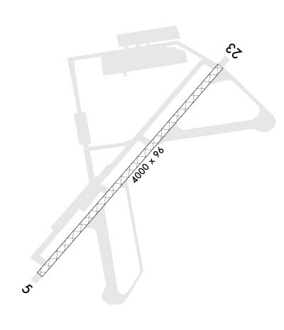
| Rwy | Rwy | |||||||
| 3848x96 | 3848' | 3848x96 | 3848' | |||||
| Runway ID | Single Wheel | Double Wheel | Double Tandem Wheel | Dual Double Wheel |
| 05/23 | 57,000 | 150,000 | N/A | N/A |
| These numbers are Advisory and are not limits. The Airport Manager should have more accurate Weight Limits | ||||
| FltPlan does not have IFR approach charts available for KNJM. |
 Airport Diagram might not be current. | |
| Facility Name: | BOGUE FLD MCALF |
| City Name: | SWANSBORO |
| County: | CARTERET |
| State abbrev: | NC |
| State Name: | NORTH CAROLINA |
| Ownership: | NAVY OWNED |
| Use: | PRIVATE |
| Owner's Name: | US NAVY |
| Address: | OCEANOGRAPHIC OFC - CODE 3142 |
| WASHINGTON, DC 20373 | |
| Owner's Phone: | |
| Manager's Name: | |
| Address: | |
| Phone: | |
| FAA Region: | SOUTHERN |
| FAA Field Office: | MEM |
| Date | Sunrise | Sunset |
|---|---|---|
| 04/24/24 Wednesday | 6:25 | 19:48 |
| 04/25/24 Thursday | 6:24 | 19:49 |
| 04/26/24 Friday | 6:22 | 19:50 |
| 04/27/24 Saturday | 6:21 | 19:50 |
| 04/28/24 Sunday | 6:20 | 19:51 |
| 04/29/24 Monday | 6:19 | 19:52 |
| 04/30/24 Tuesday | 6:18 | 19:53 |
| 05/01/24 Wednesday | 6:17 | 19:54 |
| 05/02/24 Thursday | 6:16 | 19:54 |
| 05/03/24 Friday | 6:15 | 19:55 |
| 05/04/24 Saturday | 6:14 | 19:56 |
| 05/05/24 Sunday | 6:13 | 19:57 |
| 05/06/24 Monday | 6:12 | 19:58 |
| 05/07/24 Tuesday | 6:11 | 19:58 |
| Airport Attendance Schedule | *; ATTENDED 1200-2000Z+ MON-FRI EXC FEDERAL HOLIDAYS. AFTER HOURS AVAILABLE WITH PRIOR CDN WITH AOPS. |
| Airport Status | OPERATIONAL (This Status can change at any time - please check NOTAMS) |
| Airport Lighting Schedule | AVBL ONLY DURING HRS OF OPERATION. |
| Airport Storage Available | NONE |
| Extra Services Available | NONE |
| Wind Indicator | NONE |
| Control Tower | YES |
| CTAF Frequency | 126.450 |
| Unicom Frequency | |
| Rotating Beacon Color | WG |
| Segmented Circle | NO |
| Landing Fee |
| Airport Inspected | No Inspection Data Available performed by the OWNER |
| Inspection Date | Unknown |
| Type of Fuel Available | None |
| Airframe Repair Service | None |
| Power Plant Repair Service | None |
| Latitude | N3441.4 |
| Longitude | W07701.7 (ESTIMATED) |
| Arpt Elevation | 21ft (ESTIMATED) |
| Magnetic Variation | 08W |
| 4 miles E | of SWANSBORO |
| Traffic Pattern Altitude | |
| Sectional Chart | CHARLOTTE |
| Operations (Reported) | Yearly | Avg. Daily |
|---|---|---|
| General Aviation Transient | 0 | 0 |
| General Aviation Local | 0 | 0 |
| Air Taxi | 0 | 0 |
| Commerical | 0 | 0 |
| Commuter | 0 | 0 |
| Military | 0 | 0 |
| Aircraft based on Field | |
|---|---|
| General Aviation Singles | 0 |
| General Aviation Multi | 0 |
| Jet Aircraft | 0 |
| General Aviation Helicopters | 0 |
| Military Aircraft | 0 |
| Gliders | 0 |
| Ultralights | 0 |
| FSS on field | NO |
| FSS tie-in | RALEIGH |
| FSS Phone | 1-800-WX-BRIEF |
| Who issues Notams | NKT |
| Notam D service at airport | YES |
| ARTCC Name | WASHINGTON |
| Airport Certification | |
| Aircraft Rescue & Firefighting Index | None |
| Airport of Entry | No |
| Custom Landing Rights | No |
| Joint Civil/Military | No |
| Military Landing rights | No |
| BEARING STRENGTH RWY 05-23: ST175 |
| REMARKS-MISC: VERT TKOF OF R/W ACFT FR CONFINED AREA LANDING (CAL) SITES LCTD 800 FT SE OF APCH END RY 23. |
| A-GEAR: RWY 5/23 M31(B); RWY 5 1020'. RWY 23 1023 '. |
| WHEN ATCT CLSD, FOR CD CTC WASHINGTON ARTCC AT 703-771-3587. |
| FUEL: J5 |
| FLUID: SP |
| TRAN ALERT: NO HGR, ACFT SVC OR TRAN MAINT AVBL. HOT REFUL REQ QUALIFIED CREW MEMBER PRESENT TO ASSIST. |
| CAUTION: ALL RWY AND TWY SFC CONSIST OF AM-2 ALUMINUM MATTING COATED WITH NON-SKID ALL WX SFC, BA GOOD, RCR 19-25. TFC PAT - LEFT TFC: RWY 05, 1000' 1 1/2 NM ABEAM AND OUTSIDE WHITE OAK ELEMENTARY SCHOOL; RWY 23, 1000' 1 1/4 NM ABEAM. |
| MISC: VERT TKOF OF AV8 ACFT FR CONFINED AREA LANDING (CAL) SITES LCTD 800' SE OF APCH END RWY 23. |
| M31(B) ARRESTING GEAR 1020 FT FROM RY 05 & 23 THLDS. |
| RWY 05/2 3 RYS 05 AND 23 APCH LGTS NSTD. APCH LGTS HAVE 5 BARS 100 FT APART. |
Airport Communications & Frequencies:
| ||||||||||||||||||||||||
| Runway: 05 | Runway: 23 | ||
| Mag heading: | N/A | Mag heading: | N/A |
| Rwy Slope: | .18% Up | Rwy Slope: | -.18% Down |
| Approach: | Approach: | ||
| Pattern: | Right Traffic | Pattern: | Left Traffic |
| Markings: | Markings: | ||
| Marking Condition: | Marking Condition: | ||
| Arresting Dev: | Arresting Dev: | ||
| Lat & Long: | N3441.2 W07702.0 | Lat. & Long.: | N3441.7 W07701.5 |
| Elev: | 8.0 ft. MSL | Elev: | 15.0 ft. MSL |
| TCH: | TCH: | ||
| Visual Glide Path: | Visual Glide Path: | ||
| Displaced Threshold: | No | Displaced Threshold: | No |
| Touchdown Zone: | YES | Touchdown Zone: | YES |
| Touchdown Elev.: | 21.0 feet | Touchdown Elev.: | 21.0 feet |
| Visual Glide Slope: | Visual Glide Slope: | ||
| RVR Equipment: | RVR Equipment: | ||
| RVV Equipment: | NO | RVV Equipment: | NO |
| Approach Lights: | MALS - 1,400 foot medium intensity approach lighting system | Approach Lights: | MALS - 1,400 foot medium intensity approach lighting system |
| REIL: | YES | REIL: | YES |
| Centerline Lights: | YES | Centerline Lights: | YES |
| Touchdown lights: | NO | Touchdown lights: | NO |
| Runway Category: | Runway Category: | ||
| Declared Distances: | Declared Distances: |
