
| ||||||||||||||||||||||||||||||||
| ||||||||||||||||||||||||||||||||
| Rwy | Rwy | |||||||
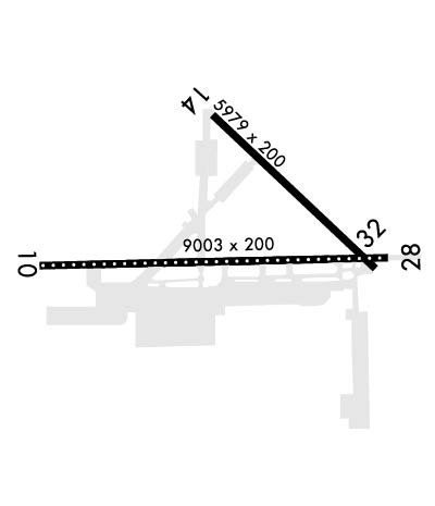
| 9003x200 | 8006' | 9003x200 | 9003' | |||||
| 5978x200 | 3244' | 5978x200 | 5978' | |||||
| Runway ID | Single Wheel | Double Wheel | Double Tandem Wheel | Dual Double Wheel |
| 10/28 | N/A | N/A | N/A | N/A |
| 14/32 | N/A | N/A | N/A | N/A |
| These numbers are Advisory and are not limits. The Airport Manager should have more accurate Weight Limits | ||||
 Airport Diagram might not be current. | |
| Facility Name: | JACKSONVILLE NAS (TOWERS FLD) |
| City Name: | JACKSONVILLE |
| County: | DUVAL |
| State abbrev: | FL |
| State Name: | FLORIDA |
| Ownership: | NAVY OWNED |
| Use: | PRIVATE |
| Owner's Name: | US NAVY |
| Address: | OCEANOGRAPHIC OFC-CODE 3142 |
| WASHINGTON, DC 20373 | |
| Owner's Phone: | |
| Manager's Name: | COMMANDING OFFICER |
| Address: | NAVAL AIR STATION |
| JACKSONVILLE, FL 32212 | |
| Phone: | |
| FAA Region: | SOUTHERN |
| FAA Field Office: | ORL |
| Date | Sunrise | Sunset |
|---|---|---|
| 04/25/24 Thursday | 6:48 | 20:01 |
| 04/26/24 Friday | 6:47 | 20:02 |
| 04/27/24 Saturday | 6:47 | 20:02 |
| 04/28/24 Sunday | 6:46 | 20:03 |
| 04/29/24 Monday | 6:45 | 20:04 |
| 04/30/24 Tuesday | 6:44 | 20:04 |
| 05/01/24 Wednesday | 6:43 | 20:05 |
| 05/02/24 Thursday | 6:42 | 20:06 |
| 05/03/24 Friday | 6:41 | 20:06 |
| 05/04/24 Saturday | 6:40 | 20:07 |
| 05/05/24 Sunday | 6:39 | 20:08 |
| 05/06/24 Monday | 6:39 | 20:08 |
| 05/07/24 Tuesday | 6:38 | 20:09 |
| 05/08/24 Wednesday | 6:37 | 20:10 |
| Airport Attendance Schedule | 7 Days A Week 1200-0400Z; OPR 1200-0400Z (DT 1100-0300) DLY. CLSD FEDERAL HOLS; OT BY NOTAM. |
| Airport Status | OPERATIONAL (This Status can change at any time - please check NOTAMS) |
| Airport Lighting Schedule | ACTIVATE-ALSF-1 RWY 10; SALSF RWY 28; PAPI RWY 10 & 28; HIRL RWY 10/28 - 134.775. |
| Airport Storage Available | NONE |
| Extra Services Available | NONE |
| Wind Indicator | NONE |
| Control Tower | YES |
| CTAF Frequency | 125.150 |
| Unicom Frequency | |
| Rotating Beacon Color | SWG |
| Segmented Circle | NO |
| Landing Fee |
| Airport Inspected | No Inspection Data Available performed by the OWNER |
| Inspection Date | Unknown |
| Type of Fuel Available | 5; -J5J5 FUELS DIV DSN 942-3906, C 904-542-3906 |
| Airframe Repair Service | NONE |
| Power Plant Repair Service | NONE |
| Latitude | N3014.0 |
| Longitude | W08140.6 (ESTIMATED) |
| Arpt Elevation | 22ft (ESTIMATED) |
| Magnetic Variation | 06W |
| 4 miles S | of JACKSONVILLE |
| Traffic Pattern Altitude | TRAN JET ACFT EXP RGT TFC RWY 10. |
| Sectional Chart | JACKSONVILLE |
| Operations (Reported) | Yearly | Avg. Daily |
|---|---|---|
| General Aviation Transient | 0 | 0 |
| General Aviation Local | 0 | 0 |
| Air Taxi | 0 | 0 |
| Commerical | 0 | 0 |
| Commuter | 0 | 0 |
| Military | 0 | 0 |
| Aircraft based on Field | |
|---|---|
| General Aviation Singles | 0 |
| General Aviation Multi | 0 |
| Jet Aircraft | 0 |
| General Aviation Helicopters | 0 |
| Military Aircraft | 0 |
| Gliders | 0 |
| Ultralights | 0 |
| FSS on field | NO |
| FSS tie-in | GAINESVILLE |
| FSS Phone | 1-800-WX-BRIEF |
| Who issues Notams | NIP |
| Notam D service at airport | YES |
| ARTCC Name | JACKSONVILLE |
| Airport Certification | |
| Aircraft Rescue & Firefighting Index | None |
| Airport of Entry | No |
| Custom Landing Rights | No |
| Joint Civil/Military | No |
| Military Landing rights | No |
| JASU: 1(NCPP-105) 2(NC-8) |
| FLUID: LOCAL SQUADRONS CTC CRYOGENIC PLANT FOR LOX SVC, DSN 942-3818, C904-542-3818, 1200-2030Z++ MON-FRI. LOX SERVICE IS NOT AVAILABLE FOR TRANSIENT AIRCRAFT. |
| TRANS ALERT: LTD TRAN MAINT, SVC AND SPACE. ACFT STAIRS AVBL 1230-0300Z++ DLY WITH 24 HR NTC. |
| RSTD: TRAN JET ACFT VFR TGL NA WO CRS RULES BRF. ALL ACFT CTC FLT PLNG 310.2, 134.775 15 MIN PRIOR TO LDG. |
| CAUTION: EXER EXTREME VIGILANCE DUR IFR APCH RWY 10 IN VMC DUE TO GENERAL AVIATION ACFT VICINITY CECIL FLD. |
| CAUTION: UNSHIELDED LGT AT BALLFIELD NIP 216/2.4 NM ON RWY 10 APCH. |
| 48 HR PPR NTC REQ EXC AIREVAC, JOSAC, NALO, AND LIFEFLTS, CTC BASEOPS DSN 942-5211, C904-542-2511. BOQ DSN 942-3138/3427/3139. |
| NS ABTMT: STOP LDG ONLY MON-SAT BTN 0300-1300Z++ & SUN BTN 0300-1700Z++. |
| CSTMS/AG/IMG: ACFT RQR INSPECTION CTC AFLD MGR DSN 942-3176, C904-542-3176 AT LEAST 48 HRS PRIOR TO ARR TO COORD INSPECTION SETUP. |
| MISC: VIP ACFT CTC BASE OPS PRIOR LDG. |
| CAUTION: TO PRECLUDE TAIL HOOK SKIP DURG A-GEAR ENGAGEMENT, AVOID RWY 10/28 CNTRLN LGTS LCTD 24 INCHES SOUTH OF RWY CNTRLN. MAX SAFE OFF-CNTR ARRESTMENT 40 FT. |
| RSTD: AFLD CLSD 2ND WED OF EV MONTH FOR AFLD MAINT FR 1200-1600Z++. |
| RSTD: PPR FOR ALL TRAN ACFT EXC AIREVAC AND LIFEFLTS, CTC AFLD MGR 48 HR PRIOR TO ARR FOR PPR NR. PPR & CALP REQ WILL CALL DSN 942-3176, C904-542-3176. BOQ DSN 942-3138/3427/3139. |
| MISC: CTC NAVAL ATLANTIC MET FAC JACKSONVILLE FOR WX ADVSY OR WX FCST DSN 942-2541, C904-542-2541. |
| CAUTION: MAT AREAS N OF RWY 10/28 NOT AUTHORIZED FOR ACFT USE. |
| CAUTION: EXTREME BIRD HAZ DUR SUMMER MONTHS. CTC TWR FOR CURRENT BASH COND. |
| CAUTION: SKYDIVING AND GLIDER OPERATIONS , SFC TO 10,000 FT, 7 MILES, IN VICINITY OF HERLONG ARPT, BTN SR & SS. |
| MISC: AIRCREWS ARE RESPONSIBLE FOR THEIR ON/OFF BASE TRANSPORTATION. AIRCREWS COORDINATE FOR CLASSIFIED MATERIAL STORGE WITH NCTAMSLANT AT DSN 942-3777 24 HR NTC. |
| MISC: WX FCST SVC AVBL 0900-0100Z++ MON-FRI. ALL OTHER HOURS WX OBSERVER ONLY. CTC FWC-N AVN CP JAX AT DSN 942-2535 C904-542-2535. CTC NAVAL AVAITION FCST CNTR FOR WX ADVSY OR WX FCST DSN 564-2594, C757-444-2594 DURING OTHER HRS. |
| JASU -1(NC-10) 1 (MSU-200NAVIA/U47A-5(HUFFER) QLFD AIRCREW RQRD. |
| AMC TRML-HRS 1230-0300++ MON-FRI. |
| A-GEAR: RWY 10-28 A-G RIGGED UPON REQ 15 MIN NTC FOR ARRESTMENT ON RWY 10-28. |
| RWY 10/2 8 FOR ACFT OPR IAW NASJAXINST 3710.1. |
Airport Communications & Frequencies:
| |||||||||||||||||||||||||||||||||||||||||||
| Runway: 10 | Runway: 28 | ||
| Mag heading: | N/A | Mag heading: | N/A |
| Rwy Slope: | -.16% Down | Rwy Slope: | .16% Up |
| Approach: | Approach: | ||
| Pattern: | Left Traffic | Pattern: | Left Traffic |
| Markings: | PRECISION INSTRUMENT | Markings: | PRECISION INSTRUMENT |
| Marking Condition: | FAIR | Marking Condition: | FAIR |
| Arresting Dev: | E28; HOOK E28(B) (2190 FT) | Arresting Dev: | E28; HOOK E28(B) (1995 FT) |
| Lat & Long: | N3013.9 W08141.6 | Lat. & Long.: | N3013.9 W08139.9 |
| Elev: | 22.5 ft. MSL | Elev: | 7.9 ft. MSL |
| TCH: | 51 ft. AGL | TCH: | 62 ft. AGL |
| Visual Glide Path: | 3.00 degrees | Visual Glide Path: | 3.00 degrees |
| Displaced Threshold: | 997 feet | Displaced Threshold: | No |
| Touchdown Zone: | YES | Touchdown Zone: | YES |
| Touchdown Elev.: | 21.1 feet | Touchdown Elev.: | 12.7 feet |
| Visual Glide Slope: | 4-Light PAPI on LEFT side of Runway; OPTICAL LANDING SYSTEM (OLS) & WAVE-OFF | Visual Glide Slope: | 4-Light PAPI on RIGHT side of Runway; OPTICAL LANDING SYSTEM (OLS) & WAVE-OFF |
| RVR Equipment: | RVR Equipment: | ||
| RVV Equipment: | NO | RVV Equipment: | NO |
| Approach Lights: | ALSF1 - standard 2,400 foot high intensity approach lighting system with sequenced flashers, Category I | Approach Lights: | ALSF1 - standard 2,400 foot high intensity approach lighting system with sequenced flashers, Category I |
| REIL: | YES | REIL: | YES |
| Centerline Lights: | YES | Centerline Lights: | YES |
| Touchdown lights: | NO | Touchdown lights: | NO |
| Runway Category: | Runway Category: | ||
| Declared Distances: | TORA:9003' TODA:9003' ASDA:9003' LDA:8006' | Declared Distances: | TORA:8006' TODA:8006' ASDA:9003' LDA:9003' |
| Runway: 14 | Runway: 32 | ||
| Mag heading: | 141° | Mag heading: | 321° |
| Rwy Slope: | -.08% Down | Rwy Slope: | .08% Up |
| Approach: | Approach: | ||
| Pattern: | Left Traffic | Pattern: | Left Traffic |
| Markings: | PRECISION INSTRUMENT | Markings: | PRECISION INSTRUMENT |
| Marking Condition: | FAIR | Marking Condition: | FAIR |
| Arresting Dev: | E28; HOOK E28(B) 1229 FT) | Arresting Dev: | |
| Lat & Long: | N3014.6 W08140.7 | Lat. & Long.: | N3013.9 W08139.9 |
| Elev: | 12.4 ft. MSL | Elev: | 7.4 ft. MSL |
| TCH: | TCH: | ||
| Visual Glide Path: | Visual Glide Path: | ||
| Displaced Threshold: | 2734 feet | Displaced Threshold: | No |
| Touchdown Zone: | YES | Touchdown Zone: | YES |
| Touchdown Elev.: | 12.5 feet | Touchdown Elev.: | 9.9 feet |
| Visual Glide Slope: | Visual Glide Slope: | ||
| RVR Equipment: | RVR Equipment: | ||
| RVV Equipment: | NO | RVV Equipment: | NO |
| Approach Lights: | Approach Lights: | OLS & WAVE-OFF | |
| REIL: | NO | REIL: | NO |
| Centerline Lights: | NO | Centerline Lights: | NO |
| Touchdown lights: | NO | Touchdown lights: | NO |
| Runway Category: | Runway Category: | ||
| Declared Distances: | Declared Distances: |
