Click here for more info on on SMS!

KNID

CHINA LAKE NAWS/ARMITAGE FIELD
CHINA LAKE
CA
Time Zone: Pacific
Lat: N 3541.1
Long: W 11741.5
Elev: 2284
Var: -14
Longest Runway: 10001
Clr Del: 274.7
Dept. ATIS: 322.37
Arr. ATIS: 322.37
Ground: 360.2
Tower: 120.15

FBO & Flight Services info for KNID

FBOs: Update your Fuel Prices

U.S.N. - PRIVATEPh: -
-
-
Service
Jet
100LL
SAF
MoGas
Fuel Avail: NO FUEL AVAILABLE
Full        Last Update: 04/25/2024 05:27:33

Self        
If you are an FBO, call 1-203-262-1700 to update your info or email: FltPlan.Advertising@garmin.com
Advertise your FBO on FltPlan.com

Runway & Approach Info for KNID
Rwy
Length
Land Dist**
Approach*
  Rwy
Length
Land Dist**
Approach*
03
10001x200  10001'          
 
  
21
  10001x200  10001'          
 
08
7111x75  7111'          
 
  
26
  7111x75  7111'          
 
14
9014x200  9014'          
 
  
32
  9014x200  9014'          
 
 * only ILS, LOC, LDA, and SDF approaches to a specific runway are shown
** For any Declared Landing Distance Available, please see A/FD or Approach plates
Runway Weight Capability (lbs.) Help
Runway IDSingle WheelDouble WheelDouble Tandem WheelDual Double Wheel
03/21N/AN/AN/AN/A
08/26N/AN/AN/AN/A
14/32N/AN/AN/AN/A
These numbers are Advisory and are not limits.   The Airport Manager should have more accurate Weight Limits
Approach Charts
Approaches    
Current Weather/Notams
Customs Information Send updates to Support@FltPlan.com
Customs Not Available
Database effective 05/16/2024
Airport Diagram of KNID
Airport Diagram might not be current.

Facility Name: CHINA LAKE NAWS (ARMITAGE FLD)
City Name: CHINA LAKE
County: KERN
State abbrev: CA
State Name: CALIFORNIA
   
Ownership: NAVY OWNED
Use: PRIVATE
Owner's Name: US NAVY
Address: OCEANOGRAPHIC OFC - CODE 3142
 WASHINGTON, DC 20373
Owner's Phone:
  
Manager's Name: COMMANDING OFFICER
Address: NAVAL AIR FACILITY
 CHINA LAKE, CA 93555
Phone:
   
FAA Region: WESTERN-PACIFIC
FAA Field Office: LAX


Sunrise / Sunset times for CHINA LAKE NAWS (ARMITAGE FLD)

DateSunriseSunset
04/24/24 Wednesday6:0619:32
04/25/24 Thursday6:0519:33
04/26/24 Friday6:0319:34
04/27/24 Saturday6:0219:35
04/28/24 Sunday6:0119:36
04/29/24 Monday6:0019:36
04/30/24 Tuesday5:5919:37
05/01/24 Wednesday5:5819:38
05/02/24 Thursday5:5719:39
05/03/24 Friday5:5619:40
05/04/24 Saturday5:5519:41
05/05/24 Sunday5:5419:42
05/06/24 Monday5:5319:42
05/07/24 Tuesday5:5219:43

Airport Facilities

Airport Attendance ScheduleMON-FRI 1530-0630Z++, SUN 2300-0100Z++; CLSD ALTN FRI. OPEN 1530-2030Z++, CLSD 2030-2300Z++, OPEN 2330-0100Z++ 1ST WORKING/NON-HOL FRI OF THE MONTH. SAT-SUN OPR BY PPR/LCL USE ONLY. SEE FLIP AP/1 SUPPLEMENTARY ARPT INFO.
Airport Status OPERATIONAL (This Status can change at any time - please check NOTAMS)
Airport Lighting ScheduleAVBL ONLY DURING HRS OF OPERATION.
Airport Storage AvailableNONE
Extra Services AvailableNONE
Wind IndicatorNONE
Control TowerYES
CTAF Frequency
Unicom Frequency
Rotating Beacon ColorSWG
Segmented CircleNO
Landing Fee

Airport Inspection Data

Airport InspectedNo Inspection Data Available performed by the OWNER
Inspection DateUnknown

Airport Services

Type of Fuel AvailableNone
Airframe Repair ServiceNONE
Power Plant Repair ServiceNONE

Geographic Data

LatitudeN3541.1
LongitudeW11741.5 (ESTIMATED)
Arpt Elevation2284ft (SURVEYED)
Magnetic Variation14E
3 miles NWof CHINA LAKE
Traffic Pattern AltitudeTFC PAT - REDUCED RWY SEPARATION STD IN EFF USN/USMC ACFT. NS ABTMT - DEP AVOID OVFT CHINA LAKE AND CITY OF RIDGECREST 2 NM SSE.
Sectional ChartLOS ANGELES

Aircraft Data

Operations (Reported)YearlyAvg. Daily
General Aviation Transient 00
General Aviation Local 00
Air Taxi 00
Commerical 00
Commuter 00
Military 00
Aircraft based on Field
General Aviation Singles 0
General Aviation Multi 0
Jet Aircraft 0
General Aviation Helicopters 0
Military Aircraft 0
Gliders 0
Ultralights 0

FAA Services

FSS on field NO
FSS tie-in RIVERSIDE
FSS Phone 1-800-WX-BRIEF
Who issues Notams NID
Notam D service at airport YES
ARTCC Name LOS ANGELES

Federal Status

Airport Certification
Aircraft Rescue & Firefighting IndexNone
Airport of EntryNo
Custom Landing RightsNo
Joint Civil/MilitaryNo
Military Landing rightsNo

Remarks

TRAN ALERT - EXP SVC DELAY. LTD TRAN SVC AVBL 1530-0300Z++ MON-FRI.
RSTD - PPR DSN 437-5301. ALL PPR ISSUED 1530-0630Z++ WEEKDAYS ONLY.
CSTMS/AG/IMG - CSTMS NOT AVBL. ACFT ENTERING FR FOREIGN COUNTRIES MUST CLEAR CSTMS PRIOR ARR.
MISC - TRAN ACFT TO/FR CHINA LAKE NID MUST CTC R2508 COMPLEX CONTROL BOARD FOR SKED/BRIEF PRIOR TO OBTAINING A PPR. PORTIONS OF APCH END RWY 26 AND ADJ TWY NOT VISIBLE FR TWR.
MISC: LTD PAX SVC AVBL.
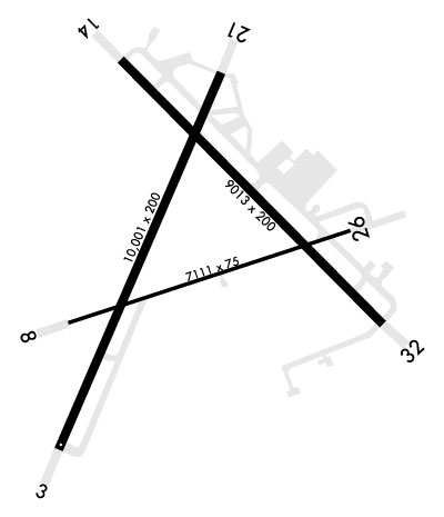
SERVICE LGT: RWY 08/26 MRKD AND LGTD 75 FT WIDE. RWY 03/21 AND 14/32 MRKD AND LGTD 200 FT WIDE.
RSTD: PPR CIVIL ACFT OFFL BUS. RSTD AFLD HRS SUBJ CHG. PILOTS FILING KNID CHINA LAKE AS AN ALTN OR EMERG DIV ARE ADVD TO CALL BASE OPS DSN 437-5475 TO VFY OPERG HRS. TWY H IS CLSD, NON-OPERATIONAL.
CAUTION - BIRD HAZ NEAR GOLF CRS, WI CLASS D AIRSPACE, OCT-APR.
CAUTION: TWY B AND TWY G NOT LGTD.
CAUTION: TWY C CLSD.
CAUTION: RWY 8/26 CLSD FOR CONST.
JASU - 3(GTC-85), 5(NC-10A1), 1(NC-10B), 1(NC-10C), 7(AM32A-108), 4(A/M47A-4), 4(MSU-200).
FUEL - F24- AVBL 1400-0700Z++ MON-THU; 1400-0430Z++ ALT THU-FRI; 2200-0700Z++ SUN
OIL - O-133-156.
Airport Communications & Frequencies:
ATIS Frequencies:   Hours(local) of Operation: CONTINUOUS
322.375
CHINA LAKE Tower Frequencies:   Hours(local) of operation: 1530-0630Z++ MON-FRI; CLSD ALTN FRI. 2300-0000Z++ SUN. OPN 1530-2030Z++, CLSD 2030Z++, OPN 2300-0000Z++ 1ST WORKING/ NON-HOL FRI OF THE MONTH. SAT-SUN OPR BY PPR/LCL USE ONLY.   
120.15
340.2
CHINA LAKE Ground Frequencies:
350.3
Clearance Delivery Frequencies:
254.25
Emergency Frequencies:
121.5
234.0
Remarks
  • VFR ADVSY SVC - (E) 133.65 126.55 127.5 291.6 348.7 REMARKS: PRVDD TO ALL PILOTS OPR WITHIN ADJ R2508. CTC JOSHUA APP.
  • RSTD AFLD HRS SUBJECT TO CHG.
  • JOSHUA Primary Approach Frequencies:  
    133.65
    348.7
    JOSHUA Primary Departure Frequencies:  
    133.65
    348.7
    VFR Advisory Frequencies:
    126.55
    127.5
    133.65
    291.6
    348.7
    Runway Identifications
    Runway Identification: 03/21
    Length: 10001 ft
    Width: 200 ft
    Surface: CONCRETE
    Edge lights: High Intensity

    Treatment: NONE
    Weight: PCN 111/R/B/W/T

     Runway: 03   Runway: 21
    Mag heading: 28°Mag heading: 208°
    Rwy Slope: -.83% DownRwy Slope: .83% Up
    Approach: Approach:
    Pattern: Left TrafficPattern: Left Traffic
    Markings: NONPRECISION INSTRUMENTMarkings: NONPRECISION INSTRUMENT
    Marking Condition: GOODMarking Condition: GOOD
    Arresting Dev: E28; HOOK E28(B) (1657 FT).Arresting Dev: E28; HOOK E28(B) (2793 FT).
    Lat & Long: N3540.5; HORIZONTAL DATUM WGS84.  W11742.5Lat. & Long.: N3541.8; HORIZONTAL DATUM WGS84.  W11741.1
    Elev: 2284.0 ft. MSLElev: 2201.0 ft. MSL
    TCH: TCH: 57 ft. AGL
    Visual Glide Path: Visual Glide Path: 3.00 degrees
    Displaced Threshold: NoDisplaced Threshold: No
    Touchdown Zone: YESTouchdown Zone: YES
    Touchdown Elev.: 2284.0 feetTouchdown Elev.: 2227.9 feet
    Visual Glide Slope: Visual Glide Slope: 4-Light PAPI on LEFT side of Runway
    RVR Equipment: RVR Equipment:
    RVV Equipment: NORVV Equipment: NO
    Approach Lights: Approach Lights: OLS
    REIL: NOREIL: NO
    Centerline Lights: NOCenterline Lights: NO
    Touchdown lights: NOTouchdown lights: NO
    Runway Category: Runway Category:
    Declared Distances: Declared Distances:
    Runway Identification: 08/26
    Length: 7111 ft
    Width: 75 ft
    Surface: CONCRETE
    Edge lights: High Intensity

    Treatment: NONE
    Weight: PCN 59 /R/B/W/T

     Runway: 08   Runway: 26
    Mag heading: 76°Mag heading: 256°
    Rwy Slope: -.48% DownRwy Slope: .48% Up
    Approach: Approach:
    Pattern: Left TrafficPattern: Left Traffic
    Markings: NONPRECISION INSTRUMENTMarkings: NONPRECISION INSTRUMENT
    Marking Condition: GOODMarking Condition: GOOD
    Arresting Dev: E28; HOOK E28(B) (1765 FT).Arresting Dev: E28; HOOK E28(B) (1546 FT).
    Lat & Long: N3541.0; HORIZONTAL DATUM WGS84.  W11742.2Lat. & Long.: N3541.0; HORIZONTAL DATUM WGS84.  W11740.8
    Elev: 2260.6 ft. MSLElev: 2226.3 ft. MSL
    TCH: TCH:
    Visual Glide Path: Visual Glide Path:
    Displaced Threshold: NoDisplaced Threshold: No
    Touchdown Zone: YESTouchdown Zone: YES
    Touchdown Elev.: 2260.6 feetTouchdown Elev.: 2238.1 feet
    Visual Glide Slope: Visual Glide Slope:
    RVR Equipment: RVR Equipment:
    RVV Equipment: NORVV Equipment: NO
    Approach Lights: Approach Lights:
    REIL: NOREIL: NO
    Centerline Lights: NOCenterline Lights: NO
    Touchdown lights: NOTouchdown lights: NO
    Runway Category: Runway Category:
    Declared Distances: Declared Distances:
    Runway Identification: 14/32
    Length: 9014 ft
    Width: 200 ft
    Surface: ASPHALT
    Edge lights: High Intensity

    Treatment: NONE
    Weight: PCN 16 /R/B/W/T

     Runway: 14   Runway: 32
    Mag heading: 140°Mag heading: 320°
    Rwy Slope: .42% UpRwy Slope: -.42% Down
    Approach: Approach:
    Pattern: Left TrafficPattern: Left Traffic
    Markings: NONPRECISION INSTRUMENTMarkings: NONPRECISION INSTRUMENT
    Marking Condition: GOODMarking Condition: GOOD
    Arresting Dev: E28; HOOK E28(B) (1501 FT).Arresting Dev: E28; HOOK E28(B) (1199 FT).
    Lat & Long: N3541.9; HORIZONTAL DATUM WGS84.  W11741.6Lat. & Long.: N3540.6; HORIZONTAL DATUM WGS84.  W11740.8
    Elev: 2203.2 ft. MSLElev: 2240.9 ft. MSL
    TCH: 52 ft. AGLTCH: 50 ft. AGL
    Visual Glide Path: 3.00 degreesVisual Glide Path: 3.00 degrees
    Displaced Threshold: NoDisplaced Threshold: No
    Touchdown Zone: YESTouchdown Zone: YES
    Touchdown Elev.: 2215.8 feetTouchdown Elev.: 2240.9 feet
    Visual Glide Slope: 4-Light PAPI on RIGHT side of RunwayVisual Glide Slope: 4-Light PAPI on RIGHT side of Runway
    RVR Equipment: RVR Equipment:
    RVV Equipment: NORVV Equipment: NO
    Approach Lights: OLSApproach Lights: OLS
    REIL: NOREIL: NO
    Centerline Lights: NOCenterline Lights: NO
    Touchdown lights: NOTouchdown lights: NO
    Runway Category: Runway Category:
    Declared Distances: Declared Distances:
    C:1/P: