Click here for more info on on SMS!

KNGT

NAVY (NOLF) GOLIAD
BERCLAIR
TX
Time Zone: Central
Lat: N 2836.7
Long: W 09736.8
Elev: 322
Var: -07
Longest Runway: 8001
CTAF: 132.87

FBO & Flight Services info for KNGT

FBOs: Update your Fuel Prices

US. NAVY (PRVT)Ph: 361-961-2247
-
Freq: 122.9
Service
Jet
100LL
SAF
MoGas
Fuel Avail: NO FUEL AVAILABLE
Full        Last Update: 04/25/2024 05:27:33

Self        
ASOS
-
Freq: 353.67  
If you are an FBO, call 1-203-262-1700 to update your info or email: FltPlan.Advertising@garmin.com
Advertise your FBO on FltPlan.com

Runway & Approach Info for KNGT
Rwy
Length
Land Dist**
Approach*
  Rwy
Length
Land Dist**
Approach*
11
8000x150  8000'          
 
  
29
  8000x150  8000'          
 
17
8001x150  8001'          
 
  
35
  8001x150  8001'          
 
 * only ILS, LOC, LDA, and SDF approaches to a specific runway are shown
** For any Declared Landing Distance Available, please see A/FD or Approach plates
Runway Weight Capability (lbs.) Help
Runway IDSingle WheelDouble WheelDouble Tandem WheelDual Double Wheel
11/29N/AN/AN/AN/A
17/35N/AN/AN/AN/A
These numbers are Advisory and are not limits.   The Airport Manager should have more accurate Weight Limits
Approach Charts
Approaches    
Current Weather/Notams
Customs Information Send updates to Support@FltPlan.com
Customs Not Available
Database effective 05/16/2024
Airport Diagram of KNGT
Airport Diagram might not be current.

Facility Name: GOLIAD NOLF
City Name: BERCLAIR
County: GOLIAD
State abbrev: TX
State Name: TEXAS
   
Ownership: NAVY OWNED
Use: PRIVATE
Owner's Name: U.S. NAVY
Address: 11001 D STREET SUITE 101, NAVAL AIR STATION
 CORPUS CHRISTI, TX 78419
Owner's Phone: 361-961-2505
  
Manager's Name: DARNELL DAVIS
Address: 11001 D STREET SUITE 101, NAVAL AIR STATION
 CORPUS CHRISTI, TX 78419
Phone: 361-961-2247
   
FAA Region: SOUTHWEST
FAA Field Office: TEX


Sunrise / Sunset times for GOLIAD NOLF

DateSunriseSunset
04/24/24 Wednesday6:5520:02
04/25/24 Thursday6:5420:03
04/26/24 Friday6:5320:03
04/27/24 Saturday6:5220:04
04/28/24 Sunday6:5220:04
04/29/24 Monday6:5120:05
04/30/24 Tuesday6:5020:06
05/01/24 Wednesday6:4920:06
05/02/24 Thursday6:4820:07
05/03/24 Friday6:4720:07
05/04/24 Saturday6:4720:08
05/05/24 Sunday6:4620:09
05/06/24 Monday6:4520:09
05/07/24 Tuesday6:4420:10

Airport Facilities

Airport Attendance ScheduleMON-FRI 1400-0400Z++
Airport Status OPERATIONAL (This Status can change at any time - please check NOTAMS)
Airport Lighting ScheduleAVBL ONLY DURING HOURS OF OPERATION.
Airport Storage AvailableNONE
Extra Services AvailableNONE
Wind IndicatorYES - (lighted)
Control TowerNO
CTAF Frequency132.875; 307.075.
Unicom Frequency
Rotating Beacon Color
Segmented CircleNO
Landing Fee

Airport Inspection Data

Airport InspectedSTATE - performed by PRIVATE CONTRACT PERSONNEL
Inspection Date03/20/2011

Airport Services

Type of Fuel AvailableNone
Airframe Repair ServiceNone
Power Plant Repair ServiceNone

Geographic Data

LatitudeN2836.7
LongitudeW09736.8 (ESTIMATED)
Arpt Elevation322ft (ESTIMATED)
Magnetic Variation07E
5 miles Nof BERCLAIR
Traffic Pattern Altitude
Sectional ChartSAN ANTONIO

Aircraft Data

Operations (Reported)YearlyAvg. Daily
General Aviation Transient 00
General Aviation Local 00
Air Taxi 00
Commerical 00
Commuter 00
Military 00
Aircraft based on Field
General Aviation Singles 0
General Aviation Multi 0
Jet Aircraft 0
General Aviation Helicopters 0
Military Aircraft 0
Gliders 0
Ultralights 0

FAA Services

FSS on field NO
FSS tie-in SAN ANGELO
FSS Phone 1-800-WX-BRIEF
Who issues Notams SJT
Notam D service at airport YES
ARTCC Name HOUSTON

Federal Status

Airport Certification
Aircraft Rescue & Firefighting IndexNone
Airport of EntryNo
Custom Landing RightsNo
Joint Civil/MilitaryNo
Military Landing rightsNo

Remarks

CAUTION: STUDENT TRAINING ACTIVITY, HI MID-AIR POTENTIAL, EXTREME VIGILANCE REQUIRED.
CAUTION: ALL ACFT CHECK-IN WITH RDO PRIOR TO ARRIVAL ON CTAF.
SERVICE: NO SERVICES AVBL.
OPR 1400Z++-SS MON-FRI. OPR OUTSIDE PUBL HR PROH. OTRS RQR PPR 72 HRS, FOR AFLD USE CTC CORPUS CHRISTI NAS BASE OPS C361-961-2505/2506/2507, DSN 861-2505/2507. PPR STRICTLY ENFORCED. TRAWING 4 EXCLUSIVE USE.
FOR CD CTC HOUSTON ARTCC AT 281-230-5622.
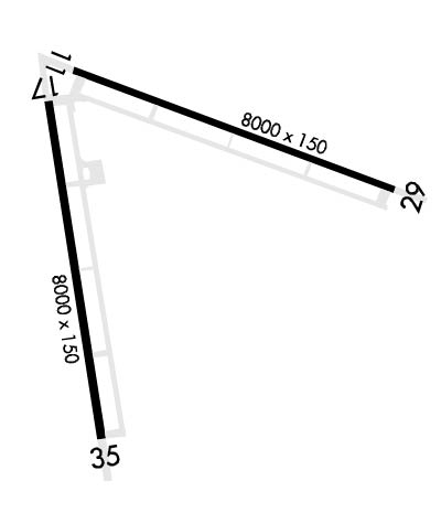
RWY 11/2 9 FIRST 1000 FT EACH RY END CONC; MIDDLE SECTION ASPH.
Airport Communications & Frequencies:
CTAF Frequency:
132.875; 307.075.
Remarks
  • APCH/DEP CTL SVC PRVDD BY HOUSTON ARTCC (ZHU) ON FREQS 135.05/353.6 (VICTORIA RCAG).
  • Runway Identifications
    Runway Identification: 11/29
    Length: 8000 ft
    Width: 150 ft
    Surface:
    Edge lights: High Intensity

    Treatment: NONE
    Weight: PCN 8 /R/B/W/T

     Runway: 11   Runway: 29
    Mag heading: 103°Mag heading: 283°
    Rwy Slope: -.67% DownRwy Slope: .67% Up
    Approach: Approach:
    Pattern: Left TrafficPattern: Left Traffic
    Markings: NONPRECISION INSTRUMENTMarkings: NONPRECISION INSTRUMENT
    Marking Condition: GOODMarking Condition: GOOD
    Arresting Dev: Arresting Dev:
    Lat & Long: N2837.2  W09737.1Lat. & Long.: N2836.7  W09735.7
    Elev: 318.0 ft. MSLElev: 264.5 ft. MSL
    TCH: 54 ft. AGLTCH: 53 ft. AGL
    Visual Glide Path: 3.00 degreesVisual Glide Path: 3.00 degrees
    Displaced Threshold: NoDisplaced Threshold: No
    Touchdown Zone: YESTouchdown Zone: YES
    Touchdown Elev.: 318.0 feetTouchdown Elev.: 284.7 feet
    Visual Glide Slope: 4-Light PAPI on LEFT side of RunwayVisual Glide Slope: 4-Light PAPI on LEFT side of Runway
    RVR Equipment: RVR Equipment:
    RVV Equipment: NORVV Equipment: NO
    Approach Lights: Approach Lights:
    REIL: NOREIL: NO
    Centerline Lights: NOCenterline Lights: NO
    Touchdown lights: YESTouchdown lights: YES
    Runway Category: Runway with a Visual ApproachRunway Category: Runway with a Visual Approach
    Declared Distances: Declared Distances:
    Obstructions: BRUSHObstructions: BRUSH
    Marked: NOT Marked/LightedMarked: NOT Marked/Lighted
    Clearance slope: Clearance slope:
    Obstruction height: 10 feet AGLObstruction height: 10 feet AGL
    Dist. from runway: 200 feetDist. from runway: 200 feet
    Centerline offset: 74 left of centerlineCenterline offset: 100 feet left of centerline
    Comments: +10 FT BRUSH & TREES 0-200 FT 74 FT L.Comments: +10 FT BRUSH & TREES 0-200 FT 90 FT R & 100 FT L.
    Runway Identification: 17/35
    Length: 8001 ft
    Width: 150 ft
    Surface:
    Edge lights: High Intensity

    Treatment: NONE
    Weight: PCN 9 /R/B/W/T

     Runway: 17   Runway: 35
    Mag heading: 163°Mag heading: 343°
    Rwy Slope: -.30% DownRwy Slope: .30% Up
    Approach: Approach:
    Pattern: Left TrafficPattern: Left Traffic
    Markings: NONPRECISION INSTRUMENTMarkings: NONPRECISION INSTRUMENT
    Marking Condition: GOODMarking Condition: GOOD
    Arresting Dev: Arresting Dev:
    Lat & Long: N2837.1  W09737.2Lat. & Long.: N2835.8  W09737.0
    Elev: 321.6 ft. MSLElev: 297.7 ft. MSL
    TCH: 54 ft. AGLTCH: 53 ft. AGL
    Visual Glide Path: 3.00 degreesVisual Glide Path: 3.00 degrees
    Displaced Threshold: NoDisplaced Threshold: No
    Touchdown Zone: YESTouchdown Zone: YES
    Touchdown Elev.: 321.6 feetTouchdown Elev.: 306.9 feet
    Visual Glide Slope: 4-Light PAPI on LEFT side of Runway; PAPI UNUSABLE BYD 8 DEGS RIGHT OF CNTRLN.Visual Glide Slope: 4-Light PAPI on LEFT side of Runway
    RVR Equipment: RVR Equipment:
    RVV Equipment: NORVV Equipment: NO
    Approach Lights: Approach Lights:
    REIL: NOREIL: NO
    Centerline Lights: NOCenterline Lights: NO
    Touchdown lights: YESTouchdown lights: YES
    Runway Category: Runway with a Visual ApproachRunway Category: Runway with a Visual Approach
    Declared Distances: Declared Distances:
    C:/P: