
| ||||||||||||||||||||||||||||||||
| ||||||||||||||||||||||||||||||||
| Rwy | Rwy | |||||||
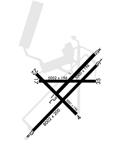
| 5001x200 | 5001' | 5001x200 | 5001' | |||||
| 5002x220 | 5002' | 5002x220 | 5002' | |||||
| 8001x200 | 8001' | 111.30 - 128° | 8001x200 | 8001' | ||||
| 5002x196 | 5002' | 5002x196 | 5002' | |||||
| Runway ID | Single Wheel | Double Wheel | Double Tandem Wheel | Dual Double Wheel |
| 04/22 | N/A | N/A | N/A | N/A |
| 13L/31R | N/A | N/A | N/A | N/A |
| 13R/31L | N/A | N/A | N/A | N/A |
| 18/36 | N/A | N/A | N/A | N/A |
| These numbers are Advisory and are not limits. The Airport Manager should have more accurate Weight Limits | ||||
 Airport Diagram might not be current. | |
| Facility Name: | CORPUS CHRISTI NAS (TRUAX FLD) |
| City Name: | CORPUS CHRISTI |
| County: | NUECES |
| State abbrev: | TX |
| State Name: | TEXAS |
| Ownership: | NAVY OWNED |
| Use: | PRIVATE |
| Owner's Name: | US NAVY |
| Address: | OCEANOGRAPHIC OFC-CODE 3142 |
| WASHINGTON, DC 20373 | |
| Owner's Phone: | |
| Manager's Name: | COMMANDING OFFICER/AIRFIELD OPS |
| Address: | NAVAL AIR STATION |
| CORPUS CHRISTI, TX 78419 | |
| Phone: | 361-961-3395; /2506. |
| FAA Region: | SOUTHWEST |
| FAA Field Office: | TEX |
| Date | Sunrise | Sunset |
|---|---|---|
| 04/17/24 Wednesday | 7:02 | 19:56 |
| 04/18/24 Thursday | 7:01 | 19:56 |
| 04/19/24 Friday | 7:00 | 19:57 |
| 04/20/24 Saturday | 6:59 | 19:57 |
| 04/21/24 Sunday | 6:58 | 19:58 |
| 04/22/24 Monday | 6:57 | 19:59 |
| 04/23/24 Tuesday | 6:56 | 19:59 |
| 04/24/24 Wednesday | 6:55 | 20:00 |
| 04/25/24 Thursday | 6:54 | 20:00 |
| 04/26/24 Friday | 6:53 | 20:01 |
| 04/27/24 Saturday | 6:52 | 20:01 |
| 04/28/24 Sunday | 6:52 | 20:02 |
| 04/29/24 Monday | 6:51 | 20:02 |
| 04/30/24 Tuesday | 6:50 | 20:03 |
| Airport Attendance Schedule | FRI 1300-0100Z++, MON-THU 1300-0500Z++; CLSD SAT, SUN & HOL. (DT 1200-0400Z MON-THU; 1200-2400Z FRI; CLSD SAT, SUN & HOL); OT CK NOTAM. |
| Airport Status | OPERATIONAL (This Status can change at any time - please check NOTAMS) |
| Airport Lighting Schedule | DUSK-DAWN. WHEN TWR CLSD ACTVT SALSF RWY 13R; PAPI RWY 04, 22, 13L, 31R, 13R, 31L, 18 & 36; HIRL RWYS 04/22, 13L/31R, 13R/31L, 18/36 - CTAF. |
| Airport Storage Available | NONE |
| Extra Services Available | NONE |
| Wind Indicator | NONE |
| Control Tower | YES |
| CTAF Frequency | 134.850; UHF CTAF - 340.2. |
| Unicom Frequency | |
| Rotating Beacon Color | SWG |
| Segmented Circle | NO |
| Landing Fee |
| Airport Inspected | No Inspection Data Available performed by the OWNER |
| Inspection Date | Unknown |
| Type of Fuel Available | None |
| Airframe Repair Service | None |
| Power Plant Repair Service | None |
| Latitude | N2741.6 |
| Longitude | W09717.4 (ESTIMATED) |
| Arpt Elevation | 18ft (SURVEYED) |
| Magnetic Variation | 03E |
| 6 miles SE | of CORPUS CHRISTI |
| Traffic Pattern Altitude | |
| Sectional Chart | BROWNSVILLE |
| Operations (Reported) | Yearly | Avg. Daily |
|---|---|---|
| General Aviation Transient | 0 | 0 |
| General Aviation Local | 0 | 0 |
| Air Taxi | 0 | 0 |
| Commerical | 0 | 0 |
| Commuter | 0 | 0 |
| Military | 0 | 0 |
| Aircraft based on Field | |
|---|---|
| General Aviation Singles | 0 |
| General Aviation Multi | 0 |
| Jet Aircraft | 0 |
| General Aviation Helicopters | 0 |
| Military Aircraft | 0 |
| Gliders | 0 |
| Ultralights | 0 |
| FSS on field | NO |
| FSS tie-in | SAN ANGELO |
| FSS Phone | 1-800-WX-BRIEF |
| Who issues Notams | NGP |
| Notam D service at airport | YES |
| ARTCC Name | HOUSTON |
| Airport Certification | |
| Aircraft Rescue & Firefighting Index | None |
| Airport of Entry | No |
| Custom Landing Rights | No |
| Joint Civil/Military | No |
| Military Landing rights | No |
| A: ALL R/W AND F/W ACFT LDG/TAXIING TO SEAWALL PPR DSN 861-2506/2507 C361-961-2506/2507. |
| A: AVOID FLT OVER POPULATED AREAS BLW 1000' AGL PRIOR TO GULF SHORE LINE. |
| TFC PAT: TRAN ACFT EXP APCH TO FULL STOP LDG ONLY WHEN SINGLE RWY OPR ARE BEING CONDUCTED, PRACTICE APCH NOT AUTH. |
| CAUTION: HI MID-AIR POTENTIAL, EXTREME VIGILANCE RQR. EXER EXTREME CAUTION VCNTY WALDRON FLD NALF LCTD 3 NM S. |
| BEARING STRENGTH RWY 13L/31R: ST175 SBTT542 TRT585. |
| JASU: 3(MSU-200, A/UA47A-5), MEPP- 2(NC-8), 3(NC-10), 2(AM32A-108). |
| FUEL: F-24. |
| FLUID: SP PRESAIR LOX LHOXRB. |
| OIL: MIL-PRF-23699 (NATO: 0-156) AND MIL-PRF-7808 L GRADE 3 (NATO: 0-148). |
| CAUTION: EXTV R/W TEST FLTS CONDUCTED MON-SAT FM TOWN OF PORT O'CONNOR TO MUSTANG BEACH ARPT (KRAS), ALG THE COAST FM 300 - 5000 FT. |
| RSTD: REFUEL/TRAN ALERT ARNG STRONGLY RECOMMENDED FOR ALL ACFT TO AVOID EXTV SVCG/TURNAROUND DELAYS OR PRK IN HI FOD RISK AREAS. |
| CSTMS/AG/IMG CSTMS, IMG AVBL FOR ACFT ARRIVING FROM OVERSEAS, PLAN ARR FROM BTN 1400-2100Z-, C361-961-2506/2507.. PILOTS RQR TO PROVIDE IDENTA-PLATE NR TO INSPECTOR FOR BILLING. |
| A: R/W ACFT DESTINED FOR CORPUS CHRISTI ARMY DEPOT TURN IN WILL REMAIN AT LEAST 1/4 NM OFF SHORE AND 500' PRIOR TO CTC NAVY CORPUS TWR. PPR ALL CCAD TRAN ACFT. TURN IN WILL ONLY BE ACCEPTED DUR NML DUTY HR, 1300-2300Z++ MON-FRI. MON-FRI. |
| A: R/W ACFT MAKE APCH TO HELIPAD ADJ HNGR 44, CTC OPS/ X-RAY CHARLIE AND GND TAXI TO/FROM PARKING. POC AVN DIV, HNGR 44. |
| A: AVOID OVFT OF BLDG S OF RAMP AREA AND AMMO DUMP E OF CONTAINMENT AREA. |
| A: TRAN AND PARTS PICKUP ACFT PARK/FUEL AT NAVY TRAN RAMP (SEPARATE PPR), DSN 861-2506/2507, C361-961-2506/2507. |
| A: ALL ACFT WITH WEAPONS ARR CCAD AFTER NML DUTY HR NOTIFY CCAD SECURITY DSN 861-3313/3314, C361-961-3313/3314. |
| A: MAJ MAINT AVBL. |
| A: LOADING/UNLOADING OF AIR CARGO - MIL/CIV DESIGNATED FOR CCAD WILL BE SCHED FOR DAYLGT HR ONLY. |
| CAUTION: BIRD ACTIVITY/BASH - SEE AP-1. |
| CAUTION: IF EQUIPPED, ALL ACFT SHALL UTILIZE UHF ATC FREQS UNLESS ASSIGNED VHF. |
| CAUTION: NMRS BIRDS VCNTY AFLD, USE EXTREME CTN DURG HVY RAIN EVENTS. |
| MISC: CLSD TWR OPS: DEPARTING IFR ACFT SHALL OBTAIN AN IFR CLNC AND RELEASE FROM SAN ANGELO FSS PRIOR TO TKOF WHEN THE FIELD IS IFR VIA GROUND LINK OR CORPUS CHRISTI APCH BY CALLING 361-299-4230. IF THE FIELD IS VFR, A VFR DEPARTURE IS AUTHORIZED. |
| RSTD: ACFT ARR/DEP PROHIBITED ONE HR PRIOR TO AFLD OPENING DUE TO AFLD PREPARATIONS EXC FOR CUST/BORDER PROTECTION. MSN CRITICAL OR OTR EVENT RQR CTC BASE OPS DSN 861-2506/2507/3395, C36-961-2506/2507/3395. |
| MISC: ACFT OPERATING TO THE SEA WALL USE CAUTION. INBD HELI CTC CORPUS CHRISTI ARMY DEPOT (CCAD) FLT OPS X-RAY CHARLIE AT 49.70, 139.0, 339.7, OR DSN 861-0520/1020, C361-961-0520/1020. |
| RSTD: PPR 48 HR ALL TRAN ACFT, DSN 861-2506/2507, C361-961-2506/2507. FLT PLANNING DSN 861-2505/2513, C361-961-2505/2513. FOR CIV AIR LDG PMT INFO CTC AFM C361-961-2506/3395. |
| TWY Y OPEN FM INTXN OF RWY 04/22 TO APCH END RWY 13R. |
| TWY S, SOUTH OF OCEAN DRIVE, LTD TO ACFT WITH A WINGSPAN OF 60 FT OR LESS. BIRD BATH, LCTD BTWN TWY Y AND TWY E, CLSD. SERVICE - FLUID - LO) AVBL ONLY WITH 7 DAYS PN OF RQMNT. |
| SIERRA TWY CLSD FM N OF HNGR 55 TO THE SEAWALL, CALL AMGR AT 361-961-2506 FOR ACES. |
| TWY C, FM TWY B TO RWY 22 IS LTD TO TW4 ACFT ONLY. |
| SERVICE: NO LAVATORY SVCS AVBL HERE. |
| TFC PAT: ALL ACFT USE LDG OR TAXI LGT WHILE IN ARPT TFC AREA. |
| SERVICE-TRAN ALERT: TRAN ACFT EXP DELAYS FROM 0900-1400L DUE TO LTD REFUL/SVC. MAINT EXTREMELY LTD BEFORE 0900L, AFTER 1400L AND DURING NON-WORK HRS. |
| RWY 0 500Z++ MON-THU; 1230-0100Z++ FRI; CLSD SAT, SUN AND HOL. |
| RWY 13L/ 31RCLSD SUN 1400-1800Z++ |
| RWY 13R/ 31LCLSD SUN 1400-1800Z++ |
Airport Communications & Frequencies:
| |||||||||||||||||||||||||||||||||||||||||||||
| Runway: 04 | Runway: 22 | ||
| Mag heading: | 42° | Mag heading: | 222° |
| Rwy Slope: | -.08% Down | Rwy Slope: | .08% Up |
| Approach: | Approach: | ||
| Pattern: | Left Traffic | Pattern: | Right Traffic |
| Markings: | PRECISION INSTRUMENT | Markings: | PRECISION INSTRUMENT |
| Marking Condition: | GOOD | Marking Condition: | GOOD |
| Arresting Dev: | Arresting Dev: | ||
| Lat & Long: | N2741.4 W09717.8 | Lat. & Long.: | N2742.0 W09717.2 |
| Elev: | 16.8 ft. MSL | Elev: | 12.9 ft. MSL |
| TCH: | 50 ft. AGL | TCH: | 52 ft. AGL |
| Visual Glide Path: | 3.00 degrees | Visual Glide Path: | 3.00 degrees |
| Displaced Threshold: | No | Displaced Threshold: | No |
| Touchdown Zone: | YES | Touchdown Zone: | YES |
| Touchdown Elev.: | 16.8 feet | Touchdown Elev.: | 14.8 feet |
| Visual Glide Slope: | 4-Light PAPI on RIGHT side of Runway | Visual Glide Slope: | 4-Light PAPI on RIGHT side of Runway |
| RVR Equipment: | RVR Equipment: | ||
| RVV Equipment: | NO | RVV Equipment: | NO |
| Approach Lights: | Approach Lights: | ||
| REIL: | YES | REIL: | YES |
| Centerline Lights: | NO | Centerline Lights: | NO |
| Touchdown lights: | NO | Touchdown lights: | NO |
| Runway Category: | Runway Category: | ||
| Declared Distances: | Declared Distances: |
| Runway: 13L | Runway: 31R | ||
| Mag heading: | 131° | Mag heading: | 311° |
| Rwy Slope: | .09% Up | Rwy Slope: | -.09% Down |
| Approach: | Approach: | ||
| Pattern: | Left Traffic | Pattern: | Right Traffic |
| Markings: | NONPRECISION INSTRUMENT | Markings: | PRECISION INSTRUMENT |
| Marking Condition: | GOOD | Marking Condition: | GOOD |
| Arresting Dev: | Arresting Dev: | ||
| Lat & Long: | N2741.7 W09717.5 | Lat. & Long.: | N2741.1 W09716.9 |
| Elev: | 12.9 ft. MSL | Elev: | 17.5 ft. MSL |
| TCH: | 46 ft. AGL | TCH: | 45 ft. AGL |
| Visual Glide Path: | 3.00 degrees | Visual Glide Path: | 3.00 degrees |
| Displaced Threshold: | No | Displaced Threshold: | No |
| Touchdown Zone: | YES | Touchdown Zone: | YES |
| Touchdown Elev.: | 18.4 feet | Touchdown Elev.: | 18.4 feet |
| Visual Glide Slope: | 4-Light PAPI on LEFT side of Runway | Visual Glide Slope: | 4-Light PAPI on LEFT side of Runway |
| RVR Equipment: | RVR Equipment: | ||
| RVV Equipment: | NO | RVV Equipment: | NO |
| Approach Lights: | Approach Lights: | ||
| REIL: | NO | REIL: | NO |
| Centerline Lights: | NO | Centerline Lights: | NO |
| Touchdown lights: | NO | Touchdown lights: | NO |
| Runway Category: | Runway Category: | ||
| Declared Distances: | Declared Distances: |
| Runway: 13R | Runway: 31L | ||
| Mag heading: | 131° | Mag heading: | 311° |
| Rwy Slope: | .09% Up | Rwy Slope: | -.09% Down |
| Approach: | ILS/DME | Approach: | |
| Pattern: | Right Traffic | Pattern: | Left Traffic |
| Markings: | PRECISION INSTRUMENT | Markings: | PRECISION INSTRUMENT |
| Marking Condition: | GOOD | Marking Condition: | GOOD |
| Arresting Dev: | Arresting Dev: | ||
| Lat & Long: | N2742.0 W09718.1 | Lat. & Long.: | N2741.1 W09717.0 |
| Elev: | 9.4 ft. MSL | Elev: | 16.8 ft. MSL |
| TCH: | 47 ft. AGL | TCH: | 45 ft. AGL |
| Visual Glide Path: | 3.00 degrees | Visual Glide Path: | 3.00 degrees |
| Displaced Threshold: | No | Displaced Threshold: | No |
| Touchdown Zone: | YES | Touchdown Zone: | YES |
| Touchdown Elev.: | 12.7 feet | Touchdown Elev.: | 17.2 feet |
| Visual Glide Slope: | 4-Light PAPI on LEFT side of Runway | Visual Glide Slope: | 4-Light PAPI on LEFT side of Runway |
| RVR Equipment: | RVR Equipment: | ||
| RVV Equipment: | NO | RVV Equipment: | NO |
| Approach Lights: | SALSF | Approach Lights: | |
| REIL: | NO | REIL: | YES |
| Centerline Lights: | NO | Centerline Lights: | NO |
| Touchdown lights: | NO | Touchdown lights: | NO |
| Runway Category: | Runway Category: | ||
| Declared Distances: | Declared Distances: |
| Runway: 18 | Runway: 36 | ||
| Mag heading: | 176° | Mag heading: | 356° |
| Rwy Slope: | .08% Up | Rwy Slope: | -.08% Down |
| Approach: | Approach: | ||
| Pattern: | Right Traffic | Pattern: | Left Traffic |
| Markings: | PRECISION INSTRUMENT | Markings: | PRECISION INSTRUMENT |
| Marking Condition: | GOOD | Marking Condition: | GOOD |
| Arresting Dev: | Arresting Dev: | ||
| Lat & Long: | N2742.0 W09717.3 | Lat. & Long.: | N2741.1 W09717.3 |
| Elev: | 12.5 ft. MSL | Elev: | 16.6 ft. MSL |
| TCH: | 45 ft. AGL | TCH: | 50 ft. AGL |
| Visual Glide Path: | 3.00 degrees | Visual Glide Path: | 3.00 degrees |
| Displaced Threshold: | No | Displaced Threshold: | No |
| Touchdown Zone: | YES | Touchdown Zone: | YES |
| Touchdown Elev.: | 18.0 feet | Touchdown Elev.: | 17.7 feet |
| Visual Glide Slope: | 4-Light PAPI on LEFT side of Runway | Visual Glide Slope: | 4-Light PAPI on LEFT side of Runway |
| RVR Equipment: | RVR Equipment: | ||
| RVV Equipment: | NO | RVV Equipment: | NO |
| Approach Lights: | Approach Lights: | ||
| REIL: | YES | REIL: | YES |
| Centerline Lights: | NO | Centerline Lights: | NO |
| Touchdown lights: | NO | Touchdown lights: | NO |
| Runway Category: | Runway Category: | ||
| Declared Distances: | Declared Distances: |
