
| ||||||
|
| Rwy | Rwy | |||||||
| 3996x60 | 3996' | 3996x60 | 3996' | |||||
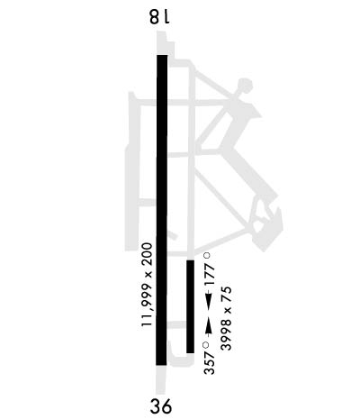
| 11999x200 | 11999' | 108.70 - 174° | 11999x200 | 11999' | 109.30 - 354° | |||
| Runway ID | Single Wheel | Double Wheel | Double Tandem Wheel | Dual Double Wheel |
| 176/356 | N/A | N/A | N/A | N/A |
| 18/36 | N/A | N/A | N/A | N/A |
| These numbers are Advisory and are not limits. The Airport Manager should have more accurate Weight Limits | ||||
 Airport Diagram might not be current. | |
| Facility Name: | FORT WORTH NAS JRB (CARSWELL FLD) |
| City Name: | FORT WORTH |
| County: | TARRANT |
| State abbrev: | TX |
| State Name: | TEXAS |
| Ownership: | NAVY OWNED |
| Use: | PRIVATE |
| Owner's Name: | U.S. NAVY |
| Address: | FORT WORTH NAS |
| FORT WORTH, TX 76127 | |
| Owner's Phone: | |
| Manager's Name: | U.S. NAVY |
| Address: | FORT WORTH NAS |
| FORT WORTH, TX 76127 | |
| Phone: | |
| FAA Region: | SOUTHWEST |
| FAA Field Office: | TEX |
| Date | Sunrise | Sunset |
|---|---|---|
| 04/19/24 Friday | 6:55 | 20:03 |
| 04/20/24 Saturday | 6:53 | 20:04 |
| 04/21/24 Sunday | 6:52 | 20:05 |
| 04/22/24 Monday | 6:51 | 20:06 |
| 04/23/24 Tuesday | 6:50 | 20:06 |
| 04/24/24 Wednesday | 6:49 | 20:07 |
| 04/25/24 Thursday | 6:48 | 20:08 |
| 04/26/24 Friday | 6:47 | 20:08 |
| 04/27/24 Saturday | 6:46 | 20:09 |
| 04/28/24 Sunday | 6:45 | 20:10 |
| 04/29/24 Monday | 6:44 | 20:11 |
| 04/30/24 Tuesday | 6:43 | 20:11 |
| 05/01/24 Wednesday | 6:42 | 20:12 |
| 05/02/24 Thursday | 6:41 | 20:13 |
| Airport Attendance Schedule | OT BY NOTAM, MON-FRI 1300-0500Z++, SAT-SUN 1500-2300Z++ |
| Airport Status | OPERATIONAL (This Status can change at any time - please check NOTAMS) |
| Airport Lighting Schedule | AVBL ONLY DURING HRS OF OPERATION. |
| Airport Storage Available | NONE |
| Extra Services Available | NONE |
| Wind Indicator | YES - (unlit) |
| Control Tower | YES |
| CTAF Frequency | |
| Unicom Frequency | |
| Rotating Beacon Color | WG |
| Segmented Circle | NO |
| Landing Fee | NO |
| Airport Inspected | No Inspection Data Available performed by the OWNER |
| Inspection Date | Unknown |
| Type of Fuel Available | None |
| Airframe Repair Service | MAJOR |
| Power Plant Repair Service | MAJOR |
| Latitude | N3246.2 |
| Longitude | W09726.5 (ESTIMATED) |
| Arpt Elevation | 650ft (SURVEYED) |
| Magnetic Variation | 04E |
| 5 miles W | of FORT WORTH |
| Traffic Pattern Altitude | TPA: 1050 FT AGL RECTANGULAR, 1550 FT AGL OVERHEAD, 550 FT AGL HELICOPTER. |
| Sectional Chart | DALLAS-FT WORTH |
| Operations (Reported) | Yearly | Avg. Daily |
|---|---|---|
| General Aviation Transient | 0 | 0 |
| General Aviation Local | 0 | 0 |
| Air Taxi | 0 | 0 |
| Commerical | 0 | 0 |
| Commuter | 0 | 0 |
| Military | 0 | 0 |
| Aircraft based on Field | |
|---|---|
| General Aviation Singles | 0 |
| General Aviation Multi | 0 |
| Jet Aircraft | 0 |
| General Aviation Helicopters | 0 |
| Military Aircraft | 0 |
| Gliders | 0 |
| Ultralights | 0 |
| FSS on field | NO |
| FSS tie-in | FORT WORTH |
| FSS Phone | 1-800-WX-BRIEF |
| Who issues Notams | NFW |
| Notam D service at airport | YES |
| ARTCC Name | FORT WORTH |
| Airport Certification | |
| Aircraft Rescue & Firefighting Index | None |
| Airport of Entry | No |
| Custom Landing Rights | No |
| Joint Civil/Military | No |
| Military Landing rights | No |
| CSTMS/AG/IMG: US MIL CSTMS SKED 1400-2200Z++ MON-FRI 48 HR PN THRU NAS SECURITY DSN 739-5200, C817-782-5200. |
| JASU: 1(NCPP-105) 1(NC-8) 4(AM32A-86D) 7(AM32A-60A). |
| FUEL: OPR 1200-0430Z++. JA. |
| FLUID: SP PRESAIR LTD LOX. |
| OIL: O-133-148 LTD JOAP. |
| TRAN ALERT: NO PRIORITY BASIS. LTD TRAN SVC/MAINT AVBL, EMERG ONLY. HGR SPACE/FLEET SVC/DE-ICE UNAVBL. |
| RSTD: PPR ALL ACFT CTC AIR ODO C817-825-6411, DSN 739-5715. |
| MISC: FLT PLAN DISPATCH DSN 739-7531, C817-782-7531. DUTY DRIVER NOT AVBL. |
| MISC: LOCKHEED MARTIN OFFICIAL BUSINESS ONLY. FOR ACCESS, CTC LOCKHEED MARTIN FLT OPNS DSN 838-5677, C817-763-3624, SEE AP1 FOR ADDITIONAL INFORMATION. |
| CAUTION: MODERATE AND STRONG W WIND REDUCED AT TD PT RWY 18 BY LOCKHEED COMPLEX. BIRD HAZ. |
| AFRC - DSN 739-6888. |
| TRAN ALERT: TRANSIENT ACFT SHALL CTC TOWER ON GND FREQ PRIOR TO ENGINE START AND/OR TAXIING. |
| FLUID: LOX SVC NOT AVBL W/NON-REMOVABLE LOX CONVERTERS UFN. |
| TRAN ALERT: 48 HR PN FOR PPR ACFT REQUIRING DLY TRANSIENT/ATC SERVICE. RULES OF ATC SERVICES BRIEF REQUIRED FOR AIRCRAFT DETS OPERATING OUT OF NAS FT WORTH. |
| MISC: ON SITE WX FORECASTING AVBL, CTC 1-888-PILOT-WX (1-888-745-6899) FOR FORECASTING SVC. |
| RSTD: ADDL PPR ALL ACFT PARKING ANG RAMP, DSN 874-3256, C817-852-3256, NML OPR 1130-2215Z++ TUE-FRI; CLSD SAT, SUN, MON AND HOL. ALL TRAN ACFT CTC ANG OPS 226.9, 15 MIN PRIOR TO LDG. |
| CAUTION: TAXI ON CNTRLN, INCREASE INTERVAL. FOUR-ENG ACFT, SECURE OUTBD ENG. |
| MISC: RWY 18 FIRST 1000 FT CONCRETE, 6700 FT HI-FRICTION ASPHALT, 2800 FT GROOVED CONCRETE, REMAINING 1500 FT CONCRETE, TWY B EAST OF TWY F 50 FT. |
| BEARING STRENGTH RWY 18/36: ST175 SBTT593 TRT585. |
Airport Communications & Frequencies:
| |||||||||||||||||||||||||||||||||
| Runway: 176 | Runway: 356 | ||
| Mag heading: | N/A | Mag heading: | N/A |
| Approach: | Approach: | ||
| Pattern: | Left Traffic | Pattern: | Left Traffic |
| Markings: | Markings: | ||
| Marking Condition: | Marking Condition: | ||
| Arresting Dev: | Arresting Dev: | ||
| Lat & Long: | Lat. & Long.: | ||
| Elev: | N/A | Elev: | N/A |
| TCH: | TCH: | ||
| Visual Glide Path: | Visual Glide Path: | ||
| Displaced Threshold: | No | Displaced Threshold: | No |
| Touchdown Zone: | NO | Touchdown Zone: | NO |
| Touchdown Elev.: | Touchdown Elev.: | ||
| Visual Glide Slope: | Visual Glide Slope: | ||
| RVR Equipment: | RVR Equipment: | ||
| RVV Equipment: | NO | RVV Equipment: | NO |
| Approach Lights: | Approach Lights: | ||
| REIL: | NO | REIL: | NO |
| Centerline Lights: | NO | Centerline Lights: | NO |
| Touchdown lights: | NO | Touchdown lights: | NO |
| Runway Category: | Runway Category: | ||
| Declared Distances: | Declared Distances: |
| Runway: 18 | Runway: 36 | ||
| Mag heading: | 177° | Mag heading: | 357° |
| Rwy Slope: | .24% Up | Rwy Slope: | -.24% Down |
| Approach: | ILS/DME | Approach: | LOC/GS |
| Pattern: | Right Traffic | Pattern: | Left Traffic |
| Markings: | PRECISION INSTRUMENT | Markings: | PRECISION INSTRUMENT |
| Marking Condition: | GOOD | Marking Condition: | GOOD |
| Arresting Dev: | E28; HOOK E28(B) (1251'). | Arresting Dev: | E28; HOOK E28(B) (1375'). |
| Lat & Long: | N3247.1 W09726.5 | Lat. & Long.: | N3245.2 W09726.5 |
| Elev: | 621.5 ft. MSL | Elev: | 649.9 ft. MSL |
| TCH: | 62 ft. AGL | TCH: | 58 ft. AGL |
| Visual Glide Path: | 3.00 degrees | Visual Glide Path: | 3.00 degrees |
| Displaced Threshold: | No | Displaced Threshold: | No |
| Touchdown Zone: | YES | Touchdown Zone: | YES |
| Touchdown Elev.: | 636.2 feet | Touchdown Elev.: | 649.8 feet |
| Visual Glide Slope: | 4-Light PAPI on LEFT side of Runway | Visual Glide Slope: | 4-Light PAPI on LEFT side of Runway |
| RVR Equipment: | RVR Equipment: | ||
| RVV Equipment: | NO | RVV Equipment: | YES |
| Approach Lights: | Approach Lights: | ALSF1 - standard 2,400 foot high intensity approach lighting system with sequenced flashers, Category I | |
| REIL: | YES | REIL: | NO |
| Centerline Lights: | NO | Centerline Lights: | NO |
| Touchdown lights: | NO | Touchdown lights: | NO |
| Runway Category: | Runway Category: | ||
| Declared Distances: | Declared Distances: |
