
| ||||||||||||||||||||||||||||||||
| ||||||||||||||||||||||||||||||||
| ||||||||||||||||||||||||||||||||
| Rwy | Rwy | |||||||
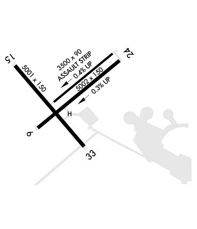
| 5002x150 | 5002' | 5002x150 | 5002' | |||||
| 3500x90 | 3500' | 3500x90 | 3500' | |||||
| 5001x150 | 5001' | 5001x150 | 5001' | |||||
| Runway ID | Single Wheel | Double Wheel | Double Tandem Wheel | Dual Double Wheel |
| 06/24 | N/A | N/A | N/A | N/A |
| 063/243 | N/A | N/A | N/A | N/A |
| 15/33 | N/A | N/A | N/A | N/A |
| These numbers are Advisory and are not limits. The Airport Manager should have more accurate Weight Limits | ||||
 Airport Diagram might not be current. | |
| Facility Name: | LAKEHURST MAXFIELD FLD; (JOINT BASE MC GUIRE DIX LAKEHURST) |
| City Name: | LAKEHURST |
| County: | OCEAN |
| State abbrev: | NJ |
| State Name: | NEW JERSEY |
| Ownership: | NAVY OWNED |
| Use: | PRIVATE |
| Owner's Name: | USAF JB MCGUIRE DIX LAKEHURST |
| Address: | 2901 FALCON LANE |
| MCGUIRE, NJ 08641 | |
| Owner's Phone: | 609-754-2714 |
| Manager's Name: | CHIEF AIRFIELD MANAGEMENT |
| Address: | 2901 FALCON LANE |
| MCGUIRE, NJ 86614 | |
| Phone: | 609-754-2714 |
| FAA Region: | EASTERN |
| FAA Field Office: | HAR |
| Date | Sunrise | Sunset |
|---|---|---|
| 04/17/24 Wednesday | 6:15 | 19:39 |
| 04/18/24 Thursday | 6:14 | 19:40 |
| 04/19/24 Friday | 6:13 | 19:41 |
| 04/20/24 Saturday | 6:11 | 19:42 |
| 04/21/24 Sunday | 6:10 | 19:43 |
| 04/22/24 Monday | 6:08 | 19:44 |
| 04/23/24 Tuesday | 6:07 | 19:45 |
| 04/24/24 Wednesday | 6:06 | 19:46 |
| 04/25/24 Thursday | 6:04 | 19:47 |
| 04/26/24 Friday | 6:03 | 19:48 |
| 04/27/24 Saturday | 6:02 | 19:49 |
| 04/28/24 Sunday | 6:00 | 19:50 |
| 04/29/24 Monday | 5:59 | 19:51 |
| 04/30/24 Tuesday | 5:58 | 19:52 |
| Airport Attendance Schedule | OPR 1300-0100Z++ MON-FRI. EXT HR 0100-0500Z++ MON-THU FOR SCHEDULED C-17 AND C-130 ASSAULT LANDING ZONE (ALZ) NGT VISION DEVICE (NVD) AND LCL NJ ANG / USMC OPS ONLY. ALZ EXTENDED HRS FOR SCHEDULED ACFT ONLY. ALZ MUST BE SCHEDULED BY THE FLT CREW AT LEAST 1 DUTY DAY PRIOR TO MSN EXECUTION. CLSD |
| Airport Status | OPERATIONAL (This Status can change at any time - please check NOTAMS) |
| Airport Lighting Schedule | PCL-120.425, KEY 3 TIMES FOR LIRL, 5 TIMES FOR MIRL, 7 TIMES FOR HIRL. MALSR ARE ON SAME KEY CODE. |
| Airport Storage Available | NONE |
| Extra Services Available | NONE |
| Wind Indicator | NONE |
| Control Tower | YES |
| CTAF Frequency | |
| Unicom Frequency | |
| Rotating Beacon Color | SWG |
| Segmented Circle | NO |
| Landing Fee |
| Airport Inspected | No Inspection Data Available performed by the OWNER |
| Inspection Date | Unknown |
| Type of Fuel Available | None |
| Airframe Repair Service | None |
| Power Plant Repair Service | None |
| Latitude | N4002.1 |
| Longitude | W07421.1 (ESTIMATED) |
| Arpt Elevation | 100ft (ESTIMATED) |
| Magnetic Variation | 11W |
| 3 miles W | of LAKEHURST |
| Traffic Pattern Altitude | |
| Sectional Chart | NEW YORK |
| Operations (Reported) | Yearly | Avg. Daily |
|---|---|---|
| General Aviation Transient | 0 | 0 |
| General Aviation Local | 0 | 0 |
| Air Taxi | 0 | 0 |
| Commerical | 0 | 0 |
| Commuter | 0 | 0 |
| Military | 0 | 0 |
| Aircraft based on Field | |
|---|---|
| General Aviation Singles | 0 |
| General Aviation Multi | 0 |
| Jet Aircraft | 0 |
| General Aviation Helicopters | 0 |
| Military Aircraft | 0 |
| Gliders | 0 |
| Ultralights | 0 |
| FSS on field | NO |
| FSS tie-in | MILLVILLE |
| FSS Phone | 1-800-WX-BRIEF |
| Who issues Notams | MIV |
| Notam D service at airport | YES |
| ARTCC Name | NEW YORK |
| Airport Certification | |
| Aircraft Rescue & Firefighting Index | None |
| Airport of Entry | No |
| Custom Landing Rights | YES |
| Joint Civil/Military | No |
| Military Landing rights | No |
| SERVICE-LGT-ROTG BCN 110 DEG 2 NM FM ARPT. |
| CAUTION: BIRD AND WILDLIFE HAZ. ANCPT CONCENTRATION OF WTR FOWL SEAGULLS AND SML BIRDS BLW 3000 FT. NAVAIR EPIC TWR COMS ARE STRICTLY ADVSY IN NATURE. INFO PROVIDED DOES NOT CONSTITUTE ATC INSTR. |
| FUEL: AVBL 1230-2330Z++. JET A WITH FUEL ADDITIVES. |
| TRAN ALERT: SVC AVB; 1230-2330Z++ MON-FRI. ADVS PRK NAVY OR ARMY LINE. |
| WX OBSERVER ONLY (ASOS AVBL). |
| RSTD: PPR FOR ALL TRAN ACFT DSN 624-2758/4147, C732-323-2758/4147. |
| TFC PAT: RGT TFC RWY 15 AND 24. |
| FIRST 150 FT OF RWY 06/24 CONC, REMAINING 4700 ASPHALT. 180 DEG TURNS RESTRICTED TI CONC PORTIONS OF RWYS ONLY. RWY 06/24 HAS A 150 FT WIDE BY 180 FT LONG COCNC PADS INSTALL AT THE THLD FOR C-17 OPR. |
| WHEN ATCT CLSD, FOR CD CTC MC GUIRE APCH AT 609-754-2767. |
| RWY 15/33 CLSD TO TRAN ACFT. |
| RWY 15/33 USE FOR LCL ASSIGNED ACFT DRG EMERG OR OPR NECESSITY ONLY. |
| CAUTION: HELO PAD SPOTS 1 AND 2 UNLIT, HANGER 5 AND HANGER 6 SE OF HELO SPOT 2 OBST LGTS INOP, A/D WIND CONES OBST LGTS INOP RWYS 06 AND 15/33. NO VFR SIGNS AT INT OF RWYS 15/33 AND 06/24. NO AIRFIELD SIGNS AT HELO SPOTS 1/2/3. AIRCREW ARE REQUIRED TO FLW TAXI FR TWR AATM. |
| CAUTION: NMRS HORIZONTAL CRACKS 5 IN WIDE AND 5 IN DEEP STARTING 50 FT EITHER SIDE FM RWY EDGE IN BOARD. |
| 12000 FT TEST FAC RWY 2 NM W CLSD TO TSNT TFC WO PPR & PREVIOUS FAC BRIEF. |
| ALTN LNDG ZONE IS GROOVED. |
| FOR CSTMS SUPPORT CTC MCGUIRE FLD ATOC AT DSN X650-2231 AT LEAST 24 HRS PRIOR TO SKED ACFT ARR. |
| ACTVT RWY 06/24 PCL ON 120.425 WHEN OPER IAW UAO MOU. |
| DUR BASH PHASE II, ONE-TIME DEP/ARR AUTH'D +/- 1 HR SR/SS UNDER REAL-TIME BWC. REAL-TIME BWC CAN ONLY BE DETERMINED WHEN THE FIELD CONDITIONS ARE AT LEAST 3000 FT/5 STATUTE MILES AND IF TOWER CAN VISUALLY CONFIRM BWC LESS THAN SEVERE. TAKEOFFS AND LANDINGS ARE NOT AUTHORIZED UNLESS APPROVED BY 305 OG/CC FOR 305 AMW, 514 AMW, AND USAF TRANSIENT AIRCRAFT OR OPERATIONS GROUP COMMANDER SERVICE EQUIVALENT FOR TENANT UNITS. ALFA ALERT ACFT ARE EXEMPT FROM THIS REQUIREMENT. COORD WVRS THRU COMD POST. |
Airport Communications & Frequencies:
| |||||||||||||||||||||||||||||
| Runway: 06 | Runway: 24 | ||
| Mag heading: | 62° | Mag heading: | 242° |
| Rwy Slope: | .25% Up | Rwy Slope: | -.25% Down |
| Approach: | Approach: | ||
| Pattern: | Left Traffic | Pattern: | Right Traffic |
| Markings: | Markings: | ||
| Marking Condition: | Marking Condition: | ||
| Arresting Dev: | Arresting Dev: | ||
| Lat & Long: | N4001.9 W07421.4 | Lat. & Long.: | N4002.4 W07420.6 |
| Elev: | 88.0 ft. MSL | Elev: | 100.6 ft. MSL |
| TCH: | TCH: | 52 ft. AGL | |
| Visual Glide Path: | Visual Glide Path: | 3.00 degrees | |
| Displaced Threshold: | No | Displaced Threshold: | No |
| Touchdown Zone: | YES | Touchdown Zone: | YES |
| Touchdown Elev.: | 88.3 feet | Touchdown Elev.: | 100.6 feet |
| Visual Glide Slope: | Visual Glide Slope: | 4-Light PAPI on LEFT side of Runway | |
| RVR Equipment: | RVR Equipment: | ||
| RVV Equipment: | NO | RVV Equipment: | NO |
| Approach Lights: | Approach Lights: | MALSR - 1,400 foot medium intensity approach lighting system with runway alignment indicator lights | |
| REIL: | NO | REIL: | NO |
| Centerline Lights: | NO | Centerline Lights: | NO |
| Touchdown lights: | NO | Touchdown lights: | NO |
| Runway Category: | Runway Category: | ||
| Declared Distances: | Declared Distances: |
| Runway: 063 | Runway: 243 | ||
| Mag heading: | 61° | Mag heading: | 242° |
| Rwy Slope: | .39% Up | Rwy Slope: | -.39% Down |
| Approach: | Approach: | ||
| Pattern: | Left Traffic | Pattern: | Left Traffic |
| Markings: | Markings: | ||
| Marking Condition: | Marking Condition: | ||
| Arresting Dev: | Arresting Dev: | ||
| Lat & Long: | N4002.1 W07421.2 | Lat. & Long.: | N4002.4 W07420.7 |
| Elev: | 85.9 ft. MSL | Elev: | 99.6 ft. MSL |
| TCH: | TCH: | ||
| Visual Glide Path: | Visual Glide Path: | ||
| Displaced Threshold: | No | Displaced Threshold: | No |
| Touchdown Zone: | YES | Touchdown Zone: | YES |
| Touchdown Elev.: | 95.0 feet | Touchdown Elev.: | 99.6 feet |
| Visual Glide Slope: | Visual Glide Slope: | ||
| RVR Equipment: | RVR Equipment: | ||
| RVV Equipment: | NO | RVV Equipment: | NO |
| Approach Lights: | Approach Lights: | ||
| REIL: | NO | REIL: | NO |
| Centerline Lights: | NO | Centerline Lights: | NO |
| Touchdown lights: | NO | Touchdown lights: | NO |
| Runway Category: | Runway Category: | ||
| Declared Distances: | Declared Distances: |
| Runway: 15 | Runway: 33 | ||
| Mag heading: | 152° | Mag heading: | 332° |
| Rwy Slope: | -.18% Down | Rwy Slope: | .18% Up |
| Approach: | Approach: | ||
| Pattern: | Right Traffic | Pattern: | Left Traffic |
| Markings: | Markings: | ||
| Marking Condition: | Marking Condition: | ||
| Arresting Dev: | Arresting Dev: | ||
| Lat & Long: | N4002.4 W07421.6 | Lat. & Long.: | N4001.7 W07420.9 |
| Elev: | 97.1 ft. MSL | Elev: | 87.9 ft. MSL |
| TCH: | TCH: | ||
| Visual Glide Path: | Visual Glide Path: | ||
| Displaced Threshold: | No | Displaced Threshold: | No |
| Touchdown Zone: | YES | Touchdown Zone: | YES |
| Touchdown Elev.: | 97.1 feet | Touchdown Elev.: | 88.3 feet |
| Visual Glide Slope: | Visual Glide Slope: | ||
| RVR Equipment: | RVR Equipment: | ||
| RVV Equipment: | NO | RVV Equipment: | NO |
| Approach Lights: | Approach Lights: | ||
| REIL: | NO | REIL: | NO |
| Centerline Lights: | NO | Centerline Lights: | NO |
| Touchdown lights: | NO | Touchdown lights: | NO |
| Runway Category: | Runway Category: | ||
| Declared Distances: | Declared Distances: |
