
| ||||||
| ||||||
| ||||||
| ||||||
|
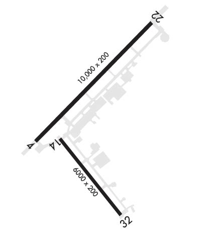
| Rwy | Rwy | |||||||
| 10000x200 | 10000' | 109.50 - 044° | 10000x200 | 10000' | ||||
| 6000x200 | 6000' | 6000x200 | 6000' | |||||
| Runway ID | Single Wheel | Double Wheel | Double Tandem Wheel | Dual Double Wheel |
| 04/22 | N/A | N/A | N/A | N/A |
| 14/32 | N/A | N/A | N/A | N/A |
| These numbers are Advisory and are not limits. The Airport Manager should have more accurate Weight Limits | ||||
 Airport Diagram might not be current. | |
| Facility Name: | NEW ORLEANS NAS JRB (ALVIN CALLENDER FLD) |
| City Name: | NEW ORLEANS |
| County: | JEFFERSON |
| State abbrev: | LA |
| State Name: | LOUISIANA |
| Ownership: | NAVY OWNED |
| Use: | PRIVATE |
| Owner's Name: | U S NAVY |
| Address: | OCEANOGRPAHIC OFC-CODE 3142 |
| WASHINGTON, D C 20373 | |
| Owner's Phone: | |
| Manager's Name: | COMMANDING OFFICER |
| Address: | NAS NEW ORLEANS |
| NEW ORLEANS, LA 70146 | |
| Phone: | |
| FAA Region: | SOUTHWEST |
| FAA Field Office: | LNM |
| Date | Sunrise | Sunset |
|---|---|---|
| 04/17/24 Wednesday | 6:30 | 19:29 |
| 04/18/24 Thursday | 6:29 | 19:30 |
| 04/19/24 Friday | 6:28 | 19:30 |
| 04/20/24 Saturday | 6:27 | 19:31 |
| 04/21/24 Sunday | 6:26 | 19:31 |
| 04/22/24 Monday | 6:25 | 19:32 |
| 04/23/24 Tuesday | 6:24 | 19:33 |
| 04/24/24 Wednesday | 6:23 | 19:33 |
| 04/25/24 Thursday | 6:22 | 19:34 |
| 04/26/24 Friday | 6:21 | 19:35 |
| 04/27/24 Saturday | 6:20 | 19:35 |
| 04/28/24 Sunday | 6:20 | 19:36 |
| 04/29/24 Monday | 6:19 | 19:36 |
| 04/30/24 Tuesday | 6:18 | 19:37 |
| Airport Attendance Schedule | MON-FRI 1300-0500Z++, SAT-SUN 1600-0000Z++; CLSD HOL EXC BY NOTAM. |
| Airport Status | OPERATIONAL (This Status can change at any time - please check NOTAMS) |
| Airport Lighting Schedule | PCL 123.8 OR 340.2. |
| Airport Storage Available | NONE |
| Extra Services Available | NONE |
| Wind Indicator | NONE |
| Control Tower | YES |
| CTAF Frequency | |
| Unicom Frequency | |
| Rotating Beacon Color | SWG |
| Segmented Circle | NO |
| Landing Fee |
| Airport Inspected | No Inspection Data Available performed by the OWNER |
| Inspection Date | Unknown |
| Type of Fuel Available | None |
| Airframe Repair Service | NONE |
| Power Plant Repair Service | NONE |
| Latitude | N2949.6 |
| Longitude | W09001.6 (ESTIMATED) |
| Arpt Elevation | 2ft (ESTIMATED) |
| Magnetic Variation | 00E |
| 3 miles S | of NEW ORLEANS |
| Traffic Pattern Altitude | TFC PAT: OVERHEAD BREAK ALT 1500'. PAT ALT 1000'. |
| Sectional Chart | NEW ORLEANS |
| Operations (Reported) | Yearly | Avg. Daily |
|---|---|---|
| General Aviation Transient | 0 | 0 |
| General Aviation Local | 0 | 0 |
| Air Taxi | 0 | 0 |
| Commerical | 0 | 0 |
| Commuter | 0 | 0 |
| Military | 0 | 0 |
| Aircraft based on Field | |
|---|---|
| General Aviation Singles | 0 |
| General Aviation Multi | 0 |
| Jet Aircraft | 0 |
| General Aviation Helicopters | 0 |
| Military Aircraft | 0 |
| Gliders | 0 |
| Ultralights | 0 |
| FSS on field | NO |
| FSS tie-in | DE RIDDER |
| FSS Phone | 1-800-WX-BRIEF |
| Who issues Notams | NBG |
| Notam D service at airport | YES |
| ARTCC Name | HOUSTON |
| Airport Certification | |
| Aircraft Rescue & Firefighting Index | None |
| Airport of Entry | YES |
| Custom Landing Rights | No |
| Joint Civil/Military | No |
| Military Landing rights | No |
| CSTMS/AG/IMG - AVBL TO MIL ACFT/PERS ONLY, COORD WITH AIRFIELD SERVICES DSN 678-3602, C504-678-3602. OTHER CSTMS REQUIREMENTS CTC C504-623-6600 FOR APPOINTMENT. |
| TRAN ALERT: OPR 1300-0500Z++. |
| CAUTION: NUMEROUS CIV ACFT OPR TO/FR CANALS VCNTY AFLD. |
| SERVICE - A-GEAR: MAINTAINED IN RAISED POSN AND IN BATTERY AT ALL TIMES, DO NOT LAND DRCT ON A-GEAR CABLES. |
| CG - OPR RSTD 0500-1300Z++ TO CG. DSN 678-3515, C504-678-6032. |
| JASU: 4(A/M-47A-4) 4(NC-10) LTD DC PWR. |
| FUEL: OPR 1330-0430Z++. FUEL DELAYS FRI-SUN. TRAN ACFT EXP SOME DELAY FOR SVC OUTSIDE NML WORKING HR. J8 |
| OIL: O-128-156. |
| FLUID: PRESAIR LHOX LOX. |
| CAUTION: BIRD HAZ. |
| OT CIV ACFT TRNS CLASS D, CTC ATC ON 123.8 FOR CLNC. |
| SERVICE: NO LAV SERVICES AVBL. |
| CAT B AFLD. |
| SERVICE: L-AOE. |
| SERVICE-LGTS: CARRIER DECK LIGHTING ON RWY 04 FOR FCLP'S AVBL UPON REQ ONE HR PRIOR. CARRIER DECK RWY 32 UNLIT; VFR/DAY USE ONLY |
| ANG- LA ANG AM OPS OPR 1330-2130Z++ TUES-FRI AND UNIT TRNG ACT WEEKEND.LA ANG AM OPS, DSN 457-8637, C504-391-8637, FAX DSN 457-8671, C504-391-8671 |
| FIRE DEPT STS CAT II. |
| BASE OPS DSN 678-3101, C504-678-3101 OR FAX DSN 678-9575, C504-678-9575 |
| CAUTION: 180 DEG TURNS AND PIVOTS ON ASPH UNAUTHD. |
| SERVICE LGT- DOUBLE YELLOW TWY END LGT AT END OF TWY K/O, L AND P NOT INSTLD. |
| SERVICE: LGT- PILOT CNTRLD AFLD LGT ARE NSTD. ONLY PCL RWY 4/22 HIRL AND RWY 32 SALS. RESPONSE TIME FOR PCL IS NSTD WITH APPROX 10 SEC DELAY FROM PILOT INPUT TO LIGHT INTENS CHANGE |
| FOR CIV ACFT LDG PMT (CALP) INFO CTC AFLD MGR C504-678-4592. |
| RSTD - PPR ALL ACFT 24 HR PN, SHORT NOTICE PPR'S APPROVED ON A CASE-BY-CASE BASIS DSN 678-3602/3, C504-678-3602/3. |
| NUMEROUS BIRDS ON & INVOF ARPT. |
| RWY 04/2 2 PCL NSTD. 3 CLICKS RWY 04 MED INTS. 5 CLICKS RWY 22 MED INTS. 7 CLICKS RWY 04 HI INTS. TTINGS. |
| RWY 14/3 2 MED INTS ALL SETTINGS. |
Airport Communications & Frequencies:
| |||||||||||||||||||||||||||||||
| Runway: 04 | Runway: 22 | ||
| Mag heading: | 44° | Mag heading: | 224° |
| Rwy Slope: | .02% Up | Rwy Slope: | -.02% Down |
| Approach: | LOC/GS | Approach: | |
| Pattern: | Left Traffic | Pattern: | Right Traffic |
| Markings: | PRECISION INSTRUMENT | Markings: | PRECISION INSTRUMENT |
| Marking Condition: | GOOD | Marking Condition: | GOOD |
| Arresting Dev: | E28; HOOK E28 (B) (1500') | Arresting Dev: | E28; HOOK E28(B) (1501') |
| Lat & Long: | N2949.4 W09002.2 | Lat. & Long.: | N2950.6 W09000.9 |
| Elev: | -2.8 ft. MSL | Elev: | -1.1 ft. MSL |
| TCH: | 49 ft. AGL | TCH: | 44 ft. AGL |
| Visual Glide Path: | 3.00 degrees | Visual Glide Path: | 3.00 degrees |
| Displaced Threshold: | No | Displaced Threshold: | No |
| Touchdown Zone: | YES | Touchdown Zone: | YES |
| Touchdown Elev.: | -1.5 feet | Touchdown Elev.: | -0.5 feet |
| Visual Glide Slope: | 4-Light PAPI on LEFT side of Runway | Visual Glide Slope: | 4-Light PAPI on LEFT side of Runway |
| RVR Equipment: | RVR Equipment: | ||
| RVV Equipment: | NO | RVV Equipment: | NO |
| Approach Lights: | ALSF1 - standard 2,400 foot high intensity approach lighting system with sequenced flashers, Category I; OLS & WAVE-OFF. | Approach Lights: | ALSF1 - standard 2,400 foot high intensity approach lighting system with sequenced flashers, Category I; OLS & WAVE-OFF. |
| REIL: | YES | REIL: | YES |
| Centerline Lights: | NO | Centerline Lights: | NO |
| Touchdown lights: | NO | Touchdown lights: | NO |
| Runway Category: | Runway Category: | ||
| Declared Distances: | Declared Distances: |
| Runway: 14 | Runway: 32 | ||
| Mag heading: | 141° | Mag heading: | 321° |
| Rwy Slope: | .03% Up | Rwy Slope: | -.03% Down |
| Approach: | Approach: | ||
| Pattern: | Right Traffic | Pattern: | Left Traffic |
| Markings: | NONPRECISION INSTRUMENT | Markings: | NONPRECISION INSTRUMENT |
| Marking Condition: | GOOD | Marking Condition: | GOOD |
| Arresting Dev: | E28; HOOK E28(B) (1025') | Arresting Dev: | E28; HOOK E28(B) (1025') |
| Lat & Long: | N2949.4 W09002.0 | Lat. & Long.: | N2948.6 W09001.3 |
| Elev: | -2.5 ft. MSL | Elev: | -0.9 ft. MSL |
| TCH: | 54 ft. AGL | TCH: | 50 ft. AGL |
| Visual Glide Path: | 3.00 degrees | Visual Glide Path: | 3.00 degrees |
| Displaced Threshold: | No | Displaced Threshold: | No |
| Touchdown Zone: | YES | Touchdown Zone: | YES |
| Touchdown Elev.: | 2.1 feet | Touchdown Elev.: | 2.0 feet |
| Visual Glide Slope: | 4-Light PAPI on LEFT side of Runway | Visual Glide Slope: | 4-Light PAPI on LEFT side of Runway |
| RVR Equipment: | RVR Equipment: | ||
| RVV Equipment: | NO | RVV Equipment: | NO |
| Approach Lights: | Approach Lights: | SALS; RWY 32 - OLS. | |
| REIL: | YES | REIL: | YES |
| Centerline Lights: | NO | Centerline Lights: | NO |
| Touchdown lights: | NO | Touchdown lights: | NO |
| Runway Category: | Runway Category: | ||
| Declared Distances: | Declared Distances: |
