| |||||||||||||||||||||||||||||||||||||||||||||||||||||||||||||
| |||||||||||||||||||||||||||||||||||||||||||||||||||||||||||||
| Rwy | Rwy | |||||||
| 3632x60 | 3632' | 3632x60 | 3632' | |||||
| Runway ID | Single Wheel | Double Wheel | Double Tandem Wheel | Dual Double Wheel |
| 07/25 | N/A | N/A | N/A | N/A |
| These numbers are Advisory and are not limits. The Airport Manager should have more accurate Weight Limits | ||||
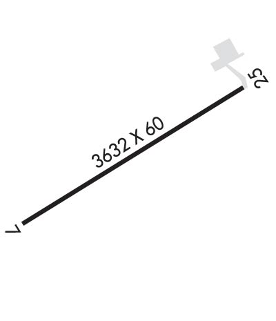 Airport Diagram might not be current. | |
| Facility Name: | BELLEFONTE |
| City Name: | BELLEFONTE |
| County: | CENTRE |
| State abbrev: | PA |
| State Name: | PENNSYLVANIA |
| Ownership: | PRIVATELY OWNED |
| Use: | OPEN TO THE PUBLIC |
| Owner's Name: | MARINA ELNITSKI |
| Address: | 225 SNOWBIRD LA |
| BELLEFONTE, PA 16823 | |
| Owner's Phone: | 814-355-7407 |
| Manager's Name: | JOHN ELNITSKI |
| Address: | 225 SNOWBIRD LA |
| BELLEFONTE, PA 16823 | |
| Phone: | 814-355-7407 |
| FAA Region: | EASTERN |
| FAA Field Office: | HAR |
| Date | Sunrise | Sunset |
|---|---|---|
| 04/24/24 Wednesday | 6:18 | 20:01 |
| 04/25/24 Thursday | 6:17 | 20:02 |
| 04/26/24 Friday | 6:15 | 20:03 |
| 04/27/24 Saturday | 6:14 | 20:04 |
| 04/28/24 Sunday | 6:12 | 20:05 |
| 04/29/24 Monday | 6:11 | 20:06 |
| 04/30/24 Tuesday | 6:10 | 20:08 |
| 05/01/24 Wednesday | 6:09 | 20:09 |
| 05/02/24 Thursday | 6:07 | 20:10 |
| 05/03/24 Friday | 6:06 | 20:11 |
| 05/04/24 Saturday | 6:05 | 20:12 |
| 05/05/24 Sunday | 6:04 | 20:13 |
| 05/06/24 Monday | 6:02 | 20:14 |
| 05/07/24 Tuesday | 6:01 | 20:15 |
| Airport Attendance Schedule | 7 Days A Week 0800-DUSK; FOR SVC AFT HRS CTC 814-355-7407 OR 814-883-7646. |
| Airport Status | OPERATIONAL (This Status can change at any time - please check NOTAMS) |
| Airport Lighting Schedule | ACTVT PAPI RWY 25; LIRL RWY 07/25 - 122.7.; ACTVT ARPT BCN - 122.7. |
| Airport Storage Available | Tie Downs, Hanger |
| Extra Services Available | Flight Instruction, Aircraft Rental, Aircraft Sales |
| Wind Indicator | YES - (unlit) |
| Control Tower | NO |
| CTAF Frequency | 122.800 |
| Unicom Frequency | 122.800 |
| Rotating Beacon Color | WG |
| Segmented Circle | NO |
| Landing Fee |
| Airport Inspected | STATE - performed by STATE AERONAUTICAL PERSONNEL |
| Inspection Date | 01/10/2024 |
| Type of Fuel Available | Grade 100LL, JET A (freeze point -40C) |
| Airframe Repair Service | MAJOR |
| Power Plant Repair Service | MAJOR |
| Latitude | N4053.1 |
| Longitude | W07749.0 (ESTIMATED) |
| Arpt Elevation | 1071ft (SURVEYED) |
| Magnetic Variation | 10W |
| 3 miles SW | of BELLEFONTE |
| Traffic Pattern Altitude | 1029 |
| Sectional Chart | DETROIT |
| Operations (Reported) | Yearly | Avg. Daily |
|---|---|---|
| General Aviation Transient | 2000 | 5 |
| General Aviation Local | 6000 | 16 |
| Air Taxi | 200 | 1 |
| Commerical | 0 | 0 |
| Commuter | 0 | 0 |
| Military | 0 | 0 |
| Aircraft based on Field | |
|---|---|
| General Aviation Singles | 19 |
| General Aviation Multi | 2 |
| Jet Aircraft | 0 |
| General Aviation Helicopters | 0 |
| Military Aircraft | 0 |
| Gliders | 0 |
| Ultralights | 2 |
| FSS on field | NO |
| FSS tie-in | ALTOONA |
| FSS Phone | 1-800-WX-BRIEF |
| Who issues Notams | AOO |
| Notam D service at airport | YES |
| ARTCC Name | NEW YORK |
| Airport Certification | |
| Aircraft Rescue & Firefighting Index | None |
| Airport of Entry | No |
| Custom Landing Rights | No |
| Joint Civil/Military | No |
| Military Landing rights | No |
| ULTRA-LIGHTS ON & INVOF ARPT. |
| ALL HELI RQRD TO USE FIXED WING TFC PAT. |
| HVY GLIDER ACT DURG DALGT HRS, ALL ALTS WI 10 NM AREA, ALL DRCTNS, SPCLY ALG RIDGE 1 NM WEST & NORTH OF ARPT. |
| CTC UNV TWR(UNIVERSITY PARK) 128.475 PRIOR TO ENTERING CLASS D ASP. |
| RWY 07/2 5 RWY 25 THR LGTS LCTD 43 FT PAST RWY THR MKG. |
Airport Communications & Frequencies:
| |||||||||||
| Runway: 07 | Runway: 25 | ||
| Mag heading: | 66° | Mag heading: | 246° |
| Rwy Slope: | -.32% Down | Rwy Slope: | .32% Up |
| Approach: | Approach: | ||
| Pattern: | Left Traffic | Pattern: | Right Traffic |
| Markings: | NONPRECISION INSTRUMENT | Markings: | NONPRECISION INSTRUMENT |
| Marking Condition: | POOR; RWY MARKINGS EXTREMELY FADED. | Marking Condition: | POOR; RWY MARKINGS EXTREMELY FADED. |
| Arresting Dev: | Arresting Dev: | ||
| Lat & Long: | N4053.0 W07749.3 | Lat. & Long.: | N4053.3 W07748.6 |
| Elev: | 1068.9 ft. MSL | Elev: | 1057.4 ft. MSL |
| TCH: | TCH: | 40 ft. AGL | |
| Visual Glide Path: | Visual Glide Path: | 3.50 degrees | |
| Displaced Threshold: | No | Displaced Threshold: | No |
| Touchdown Zone: | YES | Touchdown Zone: | YES |
| Touchdown Elev.: | 1071.5 feet | Touchdown Elev.: | 1071.5 feet |
| Visual Glide Slope: | Visual Glide Slope: | 2-Light PAPI on LEFT side of Runway | |
| RVR Equipment: | RVR Equipment: | ||
| RVV Equipment: | NO | RVV Equipment: | NO |
| Approach Lights: | Approach Lights: | ||
| REIL: | NO | REIL: | NO |
| Centerline Lights: | NO | Centerline Lights: | NO |
| Touchdown lights: | NO | Touchdown lights: | NO |
| Runway Category: | Runway with a Non-precision Approach | Runway Category: | Runway with a Non-precision Approach |
| Declared Distances: | Declared Distances: | ||
| Obstructions: | TREE | Obstructions: | |
| Marked: | NOT Marked/Lighted | Marked: | |
| Clearance slope: | 2:1 | Clearance slope: | 20:1 |
| Obstruction height: | 29 feet AGL | Obstruction height: | |
| Dist. from runway: | 270 feet | Dist. from runway: | |
| Centerline offset: | 168 right of centerline | Centerline offset: | |
| Comments: | Comments: |