Current Weather/Notams (Metars, TAFs, Notams, NWS Forecast, PIREPS, and nearby weather)
Customs Information Send updates to Support@FltPlan.com
Customs Not Available
Database effective 04/18/2024
Airport Diagram might not be current.
|
| Facility Name: | CARLISLE |
| City Name: | CARLISLE |
| County: | CUMBERLAND |
| State abbrev: | PA |
| State Name: | PENNSYLVANIA |
| | |
| Ownership: | PUBLICLY OWNED |
| Use: | OPEN TO THE PUBLIC |
| Owner's Name: | SOUTH MIDDLETON TWP |
| Address: | 520 PARK DRIVE |
| | BOILING SPRINGS, PA 17007 |
| Owner's Phone: | 717-258-5324 |
| | |
| Manager's Name: | JEFF SMITH |
| Address: | 228 PETERSBURG RD |
| | CARLISLE, PA 17013 |
| Phone: | 717-448-7730 |
| | |
| FAA Region: | EASTERN |
| FAA Field Office: | HAR |
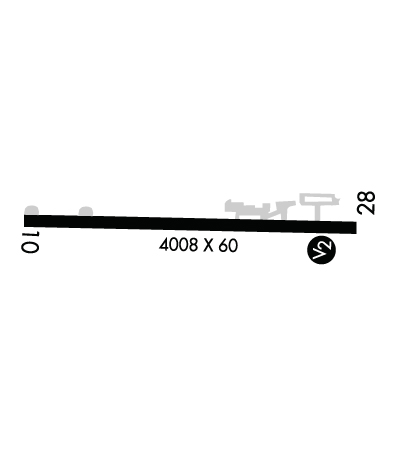
Runway Identifications
Runway Identification: 10/28Length: 4008 ft
Width: 60 ft
Surface: ASPHALT-GOOD CONDITION
Edge lights: Low IntensityTreatment: NONE
| | Runway: 10 | | Runway: 28 |
| Mag heading: | 102° | Mag heading: | 282° |
| Rwy Slope: | .19% Up | Rwy Slope: | -.19% Down |
| Approach: | | Approach: | |
| Pattern: | Left Traffic | Pattern: | Left Traffic |
| Markings: | BASIC | Markings: | NONPRECISION INSTRUMENT |
| Marking Condition: | GOOD | Marking Condition: | GOOD |
| Arresting Dev: | | Arresting Dev: | |
| Lat & Long: | N4011.3 W07710.9 | Lat. & Long.: | N4011.3 W07710.0 |
| Elev: | 502.2 ft. MSL | Elev: | 509.9 ft. MSL |
| TCH: | | TCH: | |
| Visual Glide Path: | | Visual Glide Path: | |
| Displaced Threshold: | No | Displaced Threshold: | 126 feet |
| Touchdown Zone: | YES | Touchdown Zone: | YES |
| Touchdown Elev.: | 502.6 feet | Touchdown Elev.: | 508.3 feet |
| Visual Glide Slope: | | Visual Glide Slope: | |
| RVR Equipment: | | RVR Equipment: | |
| RVV Equipment: | NO | RVV Equipment: | NO |
| Approach Lights: | | Approach Lights: | |
| REIL: | NO | REIL: | NO |
| Centerline Lights: | NO | Centerline Lights: | NO |
| Touchdown lights: | NO | Touchdown lights: | NO |
| Runway Category: | Runway with a Visual Approach | Runway Category: | Runway with a Visual Approach |
| Declared Distances: | | Declared Distances: | |
| Obstructions: | | Obstructions: | TREES |
| Marked: | | Marked: | NOT Marked/Lighted |
| Clearance slope: | 20:1 | Clearance slope: | 19:1; APCH SLOPE 20:1 TO DTHR. |
| Obstruction height: | | Obstruction height: | 100 feet AGL |
| Dist. from runway: | | Dist. from runway: | 2117 feet |
| Centerline offset: | | Centerline offset: | 259 feet left of centerline |
| Comments: | | Comments: | RWY 28 HAS 17 FT ROAD 185 FT FM RWY END ACRS CNTRLN. |

