Click here for more info on on SMS!

KN89

JOSEPH Y RESNICK
ELLENVILLE
NY
Time Zone: Eastern
Lat: N 4143.7
Long: W 07422.6
Elev: 290
Var: +14
Longest Runway: 3839
CTAF: 122.8

FBO & Flight Services info for KN89

FBOs: Update your Fuel Prices

WAWARSING ARPPh: 845-647-8401 Fax: 845-647-1046 Freq: 122.8
Service
Jet
100LL
SAF
MoGas
Full        Last Update: 04/05/2024 15:00

Self  6.20    
 Address: AIRPORT RD   NAPANOCH, NY 12458
If you are an FBO, call 1-203-262-1700 to update your info or email: FltPlan.Advertising@garmin.com
Advertise your FBO on FltPlan.com

Runway & Approach Info for KN89
Rwy
Length
Land Dist**
Approach*
  Rwy
Length
Land Dist**
Approach*
04
3839x75  3839'          
 
  
22
  3839x75  3530'          
 
 * only ILS, LOC, LDA, and SDF approaches to a specific runway are shown
** For any Declared Landing Distance Available, please see A/FD or Approach plates
Runway Weight Capability (lbs.) Help
Runway IDSingle WheelDouble WheelDouble Tandem WheelDual Double Wheel
04/22N/AN/AN/AN/A
These numbers are Advisory and are not limits.   The Airport Manager should have more accurate Weight Limits
Approach Charts
Approaches    
Current Weather/Notams
Customs Information Send updates to Support@FltPlan.com
Customs Not Available
Database effective 05/16/2024
Airport Diagram of KN89
Airport Diagram might not be current.

Facility Name: JOSEPH Y RESNICK
City Name: ELLENVILLE
County: ULSTER
State abbrev: NY
State Name: NEW YORK
   
Ownership: PUBLICLY OWNED
Use: OPEN TO THE PUBLIC
Owner's Name: TOWN OF WAWARSING
Address: 108 CANAL STREET
 ELLENVILLE, NY 12428
Owner's Phone: 845-647-6570
  
Manager's Name: TERRY HOUCK
Address: TOWN SUPERVISOR, 108 CANAL STREET
 ELLENVILLE, NY 12428
Phone: 845-647-7800
   
FAA Region: EASTERN
FAA Field Office: NYC


Sunrise / Sunset times for JOSEPH Y RESNICK

DateSunriseSunset
04/25/24 Thursday6:0119:50
04/26/24 Friday6:0019:51
04/27/24 Saturday5:5819:52
04/28/24 Sunday5:5719:53
04/29/24 Monday5:5619:54
04/30/24 Tuesday5:5419:56
05/01/24 Wednesday5:5319:57
05/02/24 Thursday5:5219:58
05/03/24 Friday5:5019:59
05/04/24 Saturday5:4920:00
05/05/24 Sunday5:4820:01
05/06/24 Monday5:4720:02
05/07/24 Tuesday5:4620:03
05/08/24 Wednesday5:4420:04

Airport Facilities

Airport Attendance Schedule7 Days A Week 0800-DARK
Airport Status OPERATIONAL (This Status can change at any time - please check NOTAMS)
Airport Lighting ScheduleACTVT REIL RWY 04 & 22; PAPI RWY 04 & 22; MIRL RWY 04/22 - CTAF.
Airport Storage AvailableTie Downs, Hanger
Extra Services AvailableFlight Instruction
Wind IndicatorYES - (lighted)
Control TowerNO
CTAF Frequency122.800
Unicom Frequency122.800
Rotating Beacon ColorWG
Segmented CircleYES
Landing FeeNO

Airport Inspection Data

Airport InspectedSTATE - performed by STATE AERONAUTICAL PERSONNEL
Inspection Date06/09/2023

Airport Services

Type of Fuel AvailableGrade 100LL
Airframe Repair ServiceMINOR
Power Plant Repair ServiceMINOR

Geographic Data

LatitudeN4143.7
LongitudeW07422.6 (ESTIMATED)
Arpt Elevation290ft (SURVEYED)
Magnetic Variation14W
1 miles NEof ELLENVILLE
Traffic Pattern Altitude
Sectional ChartNEW YORK

Aircraft Data

Operations (Reported)YearlyAvg. Daily
General Aviation Transient 8002
General Aviation Local 500014
Air Taxi 1000
Commerical 00
Commuter 00
Military 00
Aircraft based on Field
General Aviation Singles 35
General Aviation Multi 1
Jet Aircraft 0
General Aviation Helicopters 1
Military Aircraft 0
Gliders 0
Ultralights 0

FAA Services

FSS on field NO
FSS tie-in NEW YORK
FSS Phone 1-800-WX-BRIEF
Who issues Notams ISP
Notam D service at airport YES
ARTCC Name NEW YORK

Federal Status

Airport Certification
Aircraft Rescue & Firefighting IndexNone
Airport of EntryNo
Custom Landing RightsNo
Joint Civil/MilitaryNo
Military Landing rightsNo

Federal Agreements

NATIONAL PLAN OF INTEGRATED AIRPORT SYSTEMS (NPIAS)
GRANT AGREEMENTS UNDER FAAP/ADAP/AIP
ASSURANCES PURSUANT TO TITLE VI, CIVIL RIGHTS ACT OF 1964

Remarks

AVOID OVERFLIGHT OF SCHOOL & VILLAGE WHEN TAKING OFF RWY 22 OR APCH TO RWY 4, HEL OPNS FOLLOW FIXED WING FLT PAT.
FOR CD CTC NEW YORK APCH AT 516-683-2448
COLD TEMPERATURE AIRPORT. ALTITUDE CORRECTION REQUIRED AT OR BELOW -6C.
AVOID OVERFLIGHT OF HOSP & SCHOOL BUILDINGS APPROX 1 MILE SW OF RWY 22 & PRISON APPROX 1/2 MILE NE OF ARPT.
RWY 04; 60 FT TREES 200 FT FM RWY, 191 RIGHT.
RWY 22; 8 FT FENCE CROSSES RWY 24 FT FM THR.
AWOS FREQUENCY 122.8 - 5 CLICKS.
Airport Communications & Frequencies:
CTAF Frequency:
122.800
Unicom Frequency:
122.800
NEW YORK Primary Approach Frequencies:  
132.75
363.1
NEW YORK Primary Departure Frequencies:  
132.75
363.1
Runway Identifications
Runway Identification: 04/22
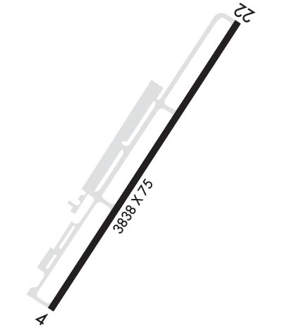
Length: 3839 ft
Width: 75 ft
Surface: ASPHALT-GOOD CONDITION
Edge lights: Medium Intensity

Treatment: NONE

 Runway: 04   Runway: 22
Mag heading: 47°Mag heading: 227°
Rwy Slope: -.17% DownRwy Slope: .17% Up
Approach: Approach:
Pattern: Left TrafficPattern: Right Traffic
Markings: NONPRECISION INSTRUMENTMarkings: NONPRECISION INSTRUMENT
Marking Condition: GOODMarking Condition: GOOD
Arresting Dev: Arresting Dev:
Lat & Long: N4143.5  W07422.8Lat. & Long.: N4144.0  W07422.4
Elev: 290.0 ft. MSLElev: 283.3 ft. MSL
TCH: 40 ft. AGLTCH: 39 ft. AGL
Visual Glide Path: 3.50 degreesVisual Glide Path: 3.00 degrees
Displaced Threshold: NoDisplaced Threshold: 309 feet
Touchdown Zone: YESTouchdown Zone: YES
Touchdown Elev.: 290.2 feetTouchdown Elev.: 289.1 feet
Visual Glide Slope: 2-Light PAPI on LEFT side of RunwayVisual Glide Slope: 2-Light PAPI on LEFT side of Runway
RVR Equipment: RVR Equipment:
RVV Equipment: NORVV Equipment: NO
Approach Lights: Approach Lights:
REIL: YESREIL: YES
Centerline Lights: NOCenterline Lights: NO
Touchdown lights: NOTouchdown lights: NO
Runway Category: Runway with a Non-precision ApproachRunway Category: Runway with a Non-precision Approach
Declared Distances: TORA:3838' TODA:3838' ASDA:3838' LDA:3538'Declared Distances: TORA:3838' TODA:3838' ASDA:3838' LDA:3538'
Obstructions: TREESObstructions:
Marked: NOT Marked/LightedMarked:
Clearance slope: 1:1Clearance slope: 20:1; RWY 22 APCH RATIO 0:1 TO DTHR BASED ON 8 FT FENCE 243 FT LEFT OF DTHR. RWY 22 CLNC OBSTN IS CORN IN FIELD.
Obstruction height: 109 feet AGLObstruction height:
Dist. from runway: 336 feetDist. from runway:
Centerline offset: 236 left of centerlineCenterline offset:
Comments: RWY 04 65 FT TREES, 0 FT FM RWY THLD, 206 FT RIGHT.Comments: RY 22 +35-55 FT TREES, 0-80 FT FROM RY THRESHOLD, 90-200 FT LEFT OF CNTRLN; -6 FT CREEK 0B 50 FT FROM THRESHOLD; +8 FT FENCE CROSSES RUNWAY 24 FT FROM THRESHOLD.
C:/P: