Current Weather/Notams (Metars, TAFs, Notams, NWS Forecast, PIREPS, and nearby weather)
Customs Information Send updates to Support@FltPlan.com
Customs Not Available
Database effective 04/18/2024
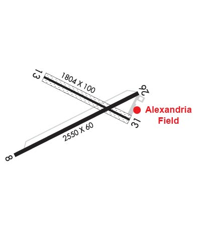
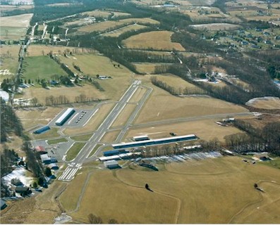
Airport Diagram might not be current. Facility Name: ALEXANDRIA City Name: PITTSTOWN County: HUNTERDON State abbrev: NJ State Name: NEW JERSEY Ownership: PRIVATELY OWNED Use: OPEN TO THE PUBLIC Owner's Name: ALEXANDRIA FIELD OF NEW JERSEY, LLC Address: 15 AIRPORT ROAD PITTSTOWN, NJ 08867 Owner's Phone: 908-399-1820 Manager's Name: TOM HEIMGARTNER Address: 15 AIRPORT ROAD PITTSTOWN, NJ 08867 Phone: 908-399-1820 FAA Region: EASTERN FAA Field Office: HAR
Runway Identifications Help
Runway Identification: 08/26 Length: 2550 ftWidth: 60 ftSurface: ASPHALT-GOOD CONDITIONEdge lights: Medium Intensity Treatment: NONE Runway: 08 Runway: 26 Mag heading: 74° Mag heading: 254° Rwy Slope: .67% Up Rwy Slope: -.67% Down Approach: Approach: Pattern: Left Traffic Pattern: Left Traffic Markings: NONPRECISION INSTRUMENT Markings: NONPRECISION INSTRUMENT Marking Condition: GOOD Marking Condition: GOOD Arresting Dev: Arresting Dev: Lat & Long: N4035.1 W07501.4 Lat. & Long.: N4035.3 W07500.9 Elev: 463.0 ft. MSL Elev: 480.0 ft. MSL TCH: 30 ft. AGL TCH: 28 ft. AGL Visual Glide Path: 4.00 degrees Visual Glide Path: 3.75 degrees Displaced Threshold: No Displaced Threshold: No Touchdown Zone: YES Touchdown Zone: YES Touchdown Elev.: 480.0 feet Touchdown Elev.: 480.0 feet Visual Glide Slope: 2-Light PAPI on RIGHT side of Runway Visual Glide Slope: 2-Light PAPI on LEFT side of Runway; PAPI UNUSBL BYD 2 DEGS LEFT OF CNTRLN. RVR Equipment: RVR Equipment: RVV Equipment: NO RVV Equipment: NO Approach Lights: Approach Lights: REIL: NO REIL: NO Centerline Lights: NO Centerline Lights: NO Touchdown lights: NO Touchdown lights: NO Runway Category: Runway with a Non-precision Approach Runway Category: Runway with a Visual Approach Declared Distances: Declared Distances: Obstructions: TREE Obstructions: TREE Marked: NOT Marked/Lighted Marked: NOT Marked/Lighted Clearance slope: 5:1 Clearance slope: Obstruction height: 50 feet AGL Obstruction height: 71 feet AGL Dist. from runway: 481 feet Dist. from runway: 232 feet Centerline offset: 102 left of centerline Centerline offset: 208 feet left of centerline Comments: Comments: +33 FT TREE, 58 FT FM RWY END, 108 FT L.
Runway Identification: 13/31 Length: 1804 ftWidth: 100 ftSurface: ASPHALT GRASS-GOOD CONDITIONEdge lights: Treatment: NONE Runway: 13 Runway: 31 Mag heading: 128° Mag heading: 308° Rwy Slope: .81% Up Rwy Slope: -.81% Down Approach: Approach: Pattern: Left Traffic Pattern: Left Traffic Markings: NUMBERS ONLY Markings: NUMBERS ONLY Marking Condition: FAIR Marking Condition: FAIR Arresting Dev: Arresting Dev: Lat & Long: N4035.4 W07501.3 Lat. & Long.: N4035.2 W07501.0 Elev: 444.0 ft. MSL Elev: 458.7 ft. MSL TCH: TCH: Visual Glide Path: Visual Glide Path: Displaced Threshold: No Displaced Threshold: No Touchdown Zone: YES Touchdown Zone: YES Touchdown Elev.: 458.7 feet Touchdown Elev.: 458.7 feet Visual Glide Slope: Visual Glide Slope: RVR Equipment: RVR Equipment: RVV Equipment: NO RVV Equipment: NO Approach Lights: Approach Lights: REIL: NO REIL: NO Centerline Lights: NO Centerline Lights: NO Touchdown lights: NO Touchdown lights: NO Runway Category: Runway with a Visual Approach Runway Category: Runway with a Visual Approach Declared Distances: Declared Distances: Obstructions: TREE Obstructions: TREE Marked: NOT Marked/Lighted Marked: NOT Marked/Lighted Clearance slope: 14:1 Clearance slope: 7:1 Obstruction height: 16 feet AGL Obstruction height: 64 feet AGL Dist. from runway: 433 feet Dist. from runway: 666 feet Centerline offset: 95 left of centerline Centerline offset: 142 feet left of centerline Comments: Comments: +47 FT TREE, 112 FT FM RWY END, 117 FT L.