Approach Charts
| FltPlan does not have IFR approach charts available for KN69. |
Current Weather/Notams (Metars, TAFs, Notams, NWS Forecast, PIREPS, and nearby weather)
Customs Information Send updates to Support@FltPlan.com
Customs Not Available
Database effective 04/18/2024
Airport Diagram might not be current.
|
| Facility Name: | STORMVILLE |
| City Name: | STORMVILLE |
| County: | DUTCHESS |
| State abbrev: | NY |
| State Name: | NEW YORK |
| | |
| Ownership: | PRIVATELY OWNED |
| Use: | OPEN TO THE PUBLIC |
| Owner's Name: | TOM CARNAHAN |
| Address: | PO BOX 85 |
| | STORMVILLE, NY 12582 |
| Owner's Phone: | 845-221-6561 |
| | |
| Manager's Name: | SEAN BOGART |
| Address: | 725 ROUTE 216 |
| | POUGHQUAG, NY 12570 |
| Phone: | (845) 227-4444 |
| | |
| FAA Region: | EASTERN |
| FAA Field Office: | NYC |
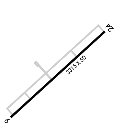
Runway Identifications
Runway Identification: 06/24Length: 3315 ft
Width: 50 ft
Surface: ASPHALT-POOR CONDITION
Edge lights: Treatment: NONE
| | Runway: 06 | | Runway: 24 |
| Mag heading: | 58° | Mag heading: | 238° |
| Rwy Slope: | .75% Up | Rwy Slope: | -.75% Down |
| Approach: | | Approach: | |
| Pattern: | Left Traffic | Pattern: | Left Traffic |
| Markings: | NONE | Markings: | NONE |
| Marking Condition: | POOR | Marking Condition: | POOR |
| Arresting Dev: | | Arresting Dev: | |
| Lat & Long: | N4134.4 W07344.2 | Lat. & Long.: | N4134.8 W07343.7 |
| Elev: | 326.0 ft. MSL | Elev: | 351.0 ft. MSL |
| TCH: | | TCH: | |
| Visual Glide Path: | | Visual Glide Path: | |
| Displaced Threshold: | No | Displaced Threshold: | No |
| Touchdown Zone: | YES | Touchdown Zone: | YES |
| Touchdown Elev.: | 358.0 feet | Touchdown Elev.: | 358.0 feet |
| Visual Glide Slope: | | Visual Glide Slope: | |
| RVR Equipment: | | RVR Equipment: | |
| RVV Equipment: | NO | RVV Equipment: | NO |
| Approach Lights: | | Approach Lights: | |
| REIL: | NO | REIL: | NO |
| Centerline Lights: | NO | Centerline Lights: | NO |
| Touchdown lights: | NO | Touchdown lights: | NO |
| Runway Category: | Runway with a Visual Approach | Runway Category: | Runway with a Visual Approach |
| Declared Distances: | | Declared Distances: | |
| Obstructions: | TREES | Obstructions: | |
| Marked: | NOT Marked/Lighted | Marked: | |
| Clearance slope: | | Clearance slope: | 20:1 |
| Obstruction height: | 45 feet AGL | Obstruction height: | |
| Dist. from runway: | 230 feet | Dist. from runway: | |
| Centerline offset: | 41 left of centerline | Centerline offset: | |
| Comments: | 65 FT TREES AT RWY END, 30-105 FT RIGHT AND 60-129 FT LEFT. VARIOUS MATERIALS MAY BE NEXT TO RWY ENDS AFTER FLEA MARKETS. | Comments: | +10 FT GRVL RDS 25 FT FM THR; 3 FT BERM PARELLEL TO 3RD ROAD 75 FT FM THR. |

