Click here for more info on on SMS!

KN52

JAARS-TOWNSEND
WAXHAW
NC
Time Zone: Eastern
Lat: N 3451.8
Long: W 08044.9
Elev: 602
Var: +07
Longest Runway: 3309
CTAF: 123.0

FBO & Flight Services info for KN52

FBOs: Update your Fuel Prices

JAARS AVIATIONPh: 704-843-6220
-
Freq: 123.0

If you are an FBO, call 1-203-262-1700 to update your info or email: FltPlan.Advertising@garmin.com
Advertise your FBO on FltPlan.com

Runway & Approach Info for KN52
Rwy
Length
Land Dist**
Approach*
  Rwy
Length
Land Dist**
Approach*
04
3309x40  3309'          
 
  
22
  3309x40  3109'          
 
 * only ILS, LOC, LDA, and SDF approaches to a specific runway are shown
** For any Declared Landing Distance Available, please see A/FD or Approach plates
Runway Weight Capability (lbs.) Help
Runway IDSingle WheelDouble WheelDouble Tandem WheelDual Double Wheel
04/22N/AN/AN/AN/A
These numbers are Advisory and are not limits.   The Airport Manager should have more accurate Weight Limits
Approach Charts
Approaches    
Current Weather/Notams
Customs Information Send updates to Support@FltPlan.com
Customs Not Available
Database effective 04/18/2024
Airport Diagram of KN52
Airport Diagram might not be current.

Facility Name: JAARS-TOWNSEND
City Name: WAXHAW
County: UNION
State abbrev: NC
State Name: NORTH CAROLINA
   
Ownership: PRIVATELY OWNED
Use: OPEN TO THE PUBLIC
Owner's Name: JAARS INC.
Address: PO BOX 248
 WAXHAW, NC 28173
Owner's Phone: 704-843-6220
  
Manager's Name: DAN MILLER
Address: 7710 JAARS ROAD
 WAXHAW, NC 28173
Phone: 704-843-6220
   
FAA Region: SOUTHERN
FAA Field Office: MEM


Sunrise / Sunset times for JAARS-TOWNSEND

DateSunriseSunset
04/16/24 Tuesday6:4919:57
04/17/24 Wednesday6:4819:58
04/18/24 Thursday6:4619:58
04/19/24 Friday6:4519:59
04/20/24 Saturday6:4420:00
04/21/24 Sunday6:4320:01
04/22/24 Monday6:4220:02
04/23/24 Tuesday6:4020:02
04/24/24 Wednesday6:3920:03
04/25/24 Thursday6:3820:04
04/26/24 Friday6:3720:05
04/27/24 Saturday6:3620:06
04/28/24 Sunday6:3520:06
04/29/24 Monday6:3420:07

Airport Facilities

Airport Attendance ScheduleMON-FRI 0800-1700; UNATNDD MAJOR HOLS.
Airport Status OPERATIONAL (This Status can change at any time - please check NOTAMS)
Airport Lighting ScheduleACTVT LIRL RWY 04/22 - CTAF.
Airport Storage AvailableTie Downs
Extra Services AvailableAvionics
Wind IndicatorYES - (lighted)
Control TowerNO
CTAF Frequency123.000
Unicom Frequency123.000
Rotating Beacon ColorWG
Segmented CircleNO
Landing FeeNO

Airport Inspection Data

Airport InspectedSTATE - performed by STATE AERONAUTICAL PERSONNEL
Inspection Date08/04/2022

Airport Services

Type of Fuel AvailableNone
Airframe Repair ServiceNone
Power Plant Repair ServiceNone

Geographic Data

LatitudeN3451.8
LongitudeW08044.9 (ESTIMATED)
Arpt Elevation602ft (SURVEYED)
Magnetic Variation07W
3 miles Sof WAXHAW
Traffic Pattern Altitude
Sectional ChartCHARLOTTE

Aircraft Data

Operations (Reported)YearlyAvg. Daily
General Aviation Transient 10003
General Aviation Local 1200033
Air Taxi 00
Commerical 00
Commuter 00
Military 00
Aircraft based on Field
General Aviation Singles 12
General Aviation Multi 0
Jet Aircraft 0
General Aviation Helicopters 1
Military Aircraft 0
Gliders 0
Ultralights 0

FAA Services

FSS on field NO
FSS tie-in RALEIGH
FSS Phone 1-800-WX-BRIEF
Who issues Notams RDU
Notam D service at airport YES
ARTCC Name ATLANTA

Federal Status

Airport Certification
Aircraft Rescue & Firefighting IndexNone
Airport of EntryNo
Custom Landing RightsNo
Joint Civil/MilitaryNo
Military Landing rightsNo

Remarks

RWY 04 HAS 5 FT DROP-OFF 150 FT FM THR, 0 BOTH.
TSNT TFC NOTE THAT ONLY JAARS PILOTS ARE PMTD TO USE NON-STD PATTERNS FOR T.
DEER ON AND INVOF ARPT.
RWY 04/22 20 FT DOWN SLOPE BTN ENDS.
SFC VARN IN RESA.
WIND CONDS PMTG AT NIGHT TKOF RWY 22 & LAND RWY 04.
TSNT TFC PROHIBITED FM LNDG ON GRASS PRACTICE AREAS.
FOR CD CTC CHARLOTTE APCH AT 704-359-0241.
RWY 04/2 2 RWY 04/22 NSTD LIRL. ONLY THREE END LGTS EACH SIDE OF RWYS & EACH SIDE OF DSPLCD THR.
Airport Communications & Frequencies:
CTAF Frequency:
123.000
Unicom Frequency:
123.000
CHARLOTTE Primary Approach Frequencies:  
120.05
307.8
CHARLOTTE Primary Departure Frequencies:  
120.05
307.8
Runway Identifications
Runway Identification: 04/22
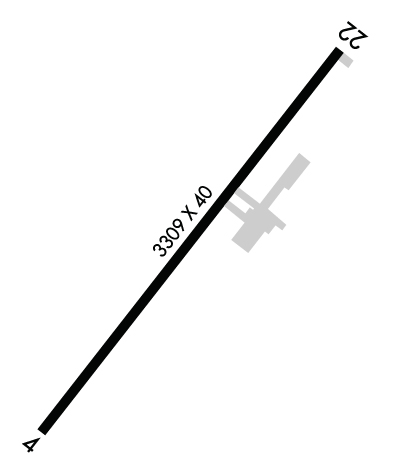
Length: 3309 ft
Width: 40 ft
Surface: ASPHALT-GOOD CONDITION
Edge lights: Low Intensity

Treatment: NONE

 Runway: 04   Runway: 22
Mag heading: 45°Mag heading: 225°
Rwy Slope: -.09% DownRwy Slope: .09% Up
Approach: Approach:
Pattern: Left TrafficPattern: Left Traffic
Markings: NONSTANDARDMarkings: NONSTANDARD
Marking Condition: GOOD; MRKGS SMALLER THAN STD.Marking Condition: GOOD; MRKGS SMALLER THAN STD.
Arresting Dev: Arresting Dev:
Lat & Long: N3451.6  W08045.1Lat. & Long.: N3452.0  W08044.7
Elev: 602.0 ft. MSLElev: 599.0 ft. MSL
TCH: TCH:
Visual Glide Path: Visual Glide Path:
Displaced Threshold: NoDisplaced Threshold: 200 feet
Touchdown Zone: YESTouchdown Zone: YES
Touchdown Elev.: 602.0 feetTouchdown Elev.: 602.0 feet
Visual Glide Slope: Visual Glide Slope:
RVR Equipment: RVR Equipment:
RVV Equipment: NORVV Equipment: NO
Approach Lights: Approach Lights:
REIL: NOREIL: NO
Centerline Lights: NOCenterline Lights: NO
Touchdown lights: NOTouchdown lights: NO
Runway Category: Runway with a Non-precision ApproachRunway Category: Runway with a Non-precision Approach
Declared Distances: Declared Distances:
Obstructions: TREESObstructions: TREES
Marked: NOT Marked/LightedMarked: NOT Marked/Lighted
Clearance slope: 1:1Clearance slope: 1:1; APCH SLOPE 5:1 TO DSPLCD THR.
Obstruction height: 56 feet AGLObstruction height: 66 feet AGL
Dist. from runway: 256 feetDist. from runway: 302 feet
Centerline offset: 113 right of centerlineCenterline offset: 140 feet right of centerline
Comments: +51 FT TREES 0-200 FT FROM THR OFFSET 133 FT RIGHT OF CNTRLN ; +51 FT TREES 0-200 FT FROM THR OFFSET 157 FT LEFT OF CNTRLN ; AND +7 FT FENCE 0-200 FT FROM THR OFFSET 112 FT RIGHT AND OFFSET 120 FT LEFT OF CNTRLN.Comments: 70 FT TREES 0-200 FT FM THR OFFSET 121 FT RIGHT; 65 FT TREES 0-200 FT FM THLR OFFSET 107 FT LEFT.
C:/P: