
| ||||||||||||||||||||||||||||||||||||||||||||
| ||||||||||||||||||||||||||||||||||||||||||||
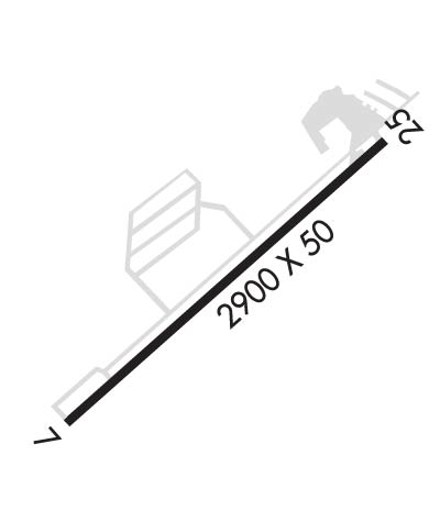
| Rwy | Rwy | |||||||
| 2900x50 | 2900' | 2900x50 | 2900' | |||||
| Runway ID | Single Wheel | Double Wheel | Double Tandem Wheel | Dual Double Wheel |
| 07/25 | N/A | N/A | N/A | N/A |
| These numbers are Advisory and are not limits. The Airport Manager should have more accurate Weight Limits | ||||
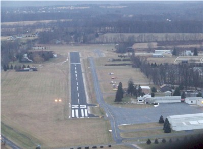
 Airport Diagram might not be current. | |
| Facility Name: | SKY MANOR |
| City Name: | PITTSTOWN |
| County: | HUNTERDON |
| State abbrev: | NJ |
| State Name: | NEW JERSEY |
| Ownership: | PRIVATELY OWNED |
| Use: | OPEN TO THE PUBLIC |
| Owner's Name: | SKY MANOR AIRPORT PARTNERS LLC |
| Address: | PO BOX 56 |
| PITTSTOWN, NJ 08867 | |
| Owner's Phone: | 908-996-4200 |
| Manager's Name: | SKY MANOR AIRPORT PARTNERS LCC |
| Address: | PO BOX 56 |
| PITTSTOWN, NJ 08867 | |
| Phone: | 908-996-4200 |
| FAA Region: | EASTERN |
| FAA Field Office: | HAR |
| Date | Sunrise | Sunset |
|---|---|---|
| 04/19/24 Friday | 6:14 | 19:44 |
| 04/20/24 Saturday | 6:13 | 19:45 |
| 04/21/24 Sunday | 6:11 | 19:46 |
| 04/22/24 Monday | 6:10 | 19:47 |
| 04/23/24 Tuesday | 6:09 | 19:48 |
| 04/24/24 Wednesday | 6:07 | 19:49 |
| 04/25/24 Thursday | 6:06 | 19:50 |
| 04/26/24 Friday | 6:04 | 19:51 |
| 04/27/24 Saturday | 6:03 | 19:52 |
| 04/28/24 Sunday | 6:02 | 19:53 |
| 04/29/24 Monday | 6:00 | 19:54 |
| 04/30/24 Tuesday | 5:59 | 19:56 |
| 05/01/24 Wednesday | 5:58 | 19:57 |
| 05/02/24 Thursday | 5:57 | 19:58 |
| Airport Attendance Schedule | CONTINUOUS |
| Airport Status | OPERATIONAL (This Status can change at any time - please check NOTAMS) |
| Airport Lighting Schedule | ACTVT REIL RWY 07 & 25; MIRL RWY 07/25; TWY LGTS - CTAF. PAPI RWY 07 & 25 OPR CONSLY. |
| Airport Storage Available | Tie Downs, Hanger |
| Extra Services Available | Flight Instruction, Aircraft Rental, Aircraft Sales |
| Wind Indicator | YES - (unlit) |
| Control Tower | NO |
| CTAF Frequency | 122.975 |
| Unicom Frequency | 122.975 |
| Rotating Beacon Color | |
| Segmented Circle | NO |
| Landing Fee | NO |
| Airport Inspected | STATE - performed by STATE AERONAUTICAL PERSONNEL |
| Inspection Date | 09/12/2023 |
| Type of Fuel Available | Grade 100LL |
| Airframe Repair Service | MAJOR |
| Power Plant Repair Service | MAJOR |
| Latitude | N4034.0 |
| Longitude | W07458.8 (ESTIMATED) |
| Arpt Elevation | 560ft (ESTIMATED) |
| Magnetic Variation | 13W |
| 2 miles SW | of PITTSTOWN |
| Traffic Pattern Altitude | |
| Sectional Chart | NEW YORK |
| Operations (Reported) | Yearly | Avg. Daily |
|---|---|---|
| General Aviation Transient | 6122 | 17 |
| General Aviation Local | 16595 | 45 |
| Air Taxi | 100 | 0 |
| Commerical | 0 | 0 |
| Commuter | 0 | 0 |
| Military | 0 | 0 |
| Aircraft based on Field | |
|---|---|
| General Aviation Singles | 100 |
| General Aviation Multi | 3 |
| Jet Aircraft | 0 |
| General Aviation Helicopters | 3 |
| Military Aircraft | 0 |
| Gliders | 0 |
| Ultralights | 2 |
| FSS on field | NO |
| FSS tie-in | MILLVILLE |
| FSS Phone | 1-800-WX-BRIEF |
| Who issues Notams | MIV |
| Notam D service at airport | YES |
| ARTCC Name | NEW YORK |
| Airport Certification | |
| Aircraft Rescue & Firefighting Index | None |
| Airport of Entry | No |
| Custom Landing Rights | No |
| Joint Civil/Military | No |
| Military Landing rights | No |
| HELICOPTER ACTIVITY ON & INVOF ARPT. |
| APN MAIN RAMP CLSD TO HEL AIR TAX AND HOVER OPS NEAR FUEL PUMP. |
| DEER & BIRDS ON & INVOF ARPT. |
| SELF-SERVE FUEL SYSTEM ON NORTH END OF TIE-DOWN RAMP. |
| FOR CD CTC ALLENTOWN APCH AT 800-728-6322. |
| AVOID OVERFLIGHT OF HORSE FARM (STABLES) 500 FT N OF ACFT HNGRS. |
| RWY 07 NOISE ABATEMENT PROCEDURES VFR DEP FLY RWY HDG UNTIL REACHING AT LEAST 1300FT MSL. |
| RWY 25 NOISE ABATEMENT PROCEDURES VFR DEP SAFETY PERMITTING AT DEP END OF RWY TURN RIGHT FLY HDG 270 UNTIL REACHING AT LEAST 1300FT MSL. |
Airport Communications & Frequencies:
| ||||||||||||||||||
| Runway: 07 | Runway: 25 | ||
| Mag heading: | 67° | Mag heading: | 247° |
| Rwy Slope: | .34% Up | Rwy Slope: | -.34% Down |
| Approach: | Approach: | ||
| Pattern: | Left Traffic | Pattern: | Left Traffic |
| Markings: | NONPRECISION INSTRUMENT | Markings: | NONPRECISION INSTRUMENT |
| Marking Condition: | GOOD | Marking Condition: | GOOD |
| Arresting Dev: | Arresting Dev: | ||
| Lat & Long: | N4033.8 W07459.0 | Lat. & Long.: | N4034.1 W07458.5 |
| Elev: | 548.0 ft. MSL | Elev: | 558.0 ft. MSL |
| TCH: | 31 ft. AGL | TCH: | 29 ft. AGL |
| Visual Glide Path: | 4.00 degrees | Visual Glide Path: | 4.00 degrees |
| Displaced Threshold: | No | Displaced Threshold: | No |
| Touchdown Zone: | YES | Touchdown Zone: | YES |
| Touchdown Elev.: | 558.0 feet | Touchdown Elev.: | 558.0 feet |
| Visual Glide Slope: | 2-Light PAPI on LEFT side of Runway; UNUSBL BYD 4 DEGS RIGHT OF CNTRLN. | Visual Glide Slope: | 2-Light PAPI on LEFT side of Runway |
| RVR Equipment: | RVR Equipment: | ||
| RVV Equipment: | NO | RVV Equipment: | NO |
| Approach Lights: | Approach Lights: | ||
| REIL: | YES | REIL: | YES |
| Centerline Lights: | NO | Centerline Lights: | NO |
| Touchdown lights: | NO | Touchdown lights: | NO |
| Runway Category: | Runway with a Non-precision Approach | Runway Category: | Runway with a Visual Approach |
| Declared Distances: | Declared Distances: | ||
| Obstructions: | TREES | Obstructions: | PLINE |
| Marked: | NOT Marked/Lighted | Marked: | LIGHTED |
| Clearance slope: | 9:1 | Clearance slope: | 18:1 |
| Obstruction height: | 93 feet AGL | Obstruction height: | 99 feet AGL |
| Dist. from runway: | 1020 feet | Dist. from runway: | 2070 feet |
| Centerline offset: | 360 right of centerline | Centerline offset: | 210 feet left of centerline |
| Comments: | Comments: | 13 FT T-HANGARS 80 FT FM THR 215 FT RIGHT. |