Click here for more info on on SMS!

KN30

CHERRY RIDGE
HONESDALE
PA
Time Zone: Eastern
Lat: N 4130.9
Long: W 07515.1
Elev: 1357
Var: +13
Longest Runway: 2986
CTAF: 122.8

FBO & Flight Services info for KN30

FBOs: Update your Fuel Prices

CHERRY RIDGEPh: 570-253-5833
-
-
Service
Jet
100LL
SAF
MoGas
Full        Caution: Fuel prices have not been updated in 34 days.
Last Update: 03/17/2024 09:46

Self  5.39    
 Address: 30 BOMBER LANE   HONESDALE, PA 18431
If you are an FBO, call 1-203-262-1700 to update your info or email: FltPlan.Advertising@garmin.com
Advertise your FBO on FltPlan.com

Runway & Approach Info for KN30
Rwy
Length
Land Dist**
Approach*
  Rwy
Length
Land Dist**
Approach*
18
2986x50  2467'          
 
  
36
  2986x50  2397'          
 
 * only ILS, LOC, LDA, and SDF approaches to a specific runway are shown
** For any Declared Landing Distance Available, please see A/FD or Approach plates
Runway Weight Capability (lbs.) Help
Runway IDSingle WheelDouble WheelDouble Tandem WheelDual Double Wheel
18/3610,000N/AN/AN/A
These numbers are Advisory and are not limits.   The Airport Manager should have more accurate Weight Limits
Approach Charts
Approaches    
Current Weather/Notams
Customs Information Send updates to Support@FltPlan.com
Customs Not Available
Database effective 04/18/2024
Airport Diagram of KN30
Airport Diagram might not be current.

Facility Name: CHERRY RIDGE
City Name: HONESDALE
County: WAYNE
State abbrev: PA
State Name: PENNSYLVANIA
   
Ownership: PRIVATELY OWNED
Use: OPEN TO THE PUBLIC
Owner's Name: EARLYNN AVIATION
Address: 30 BOMBER LANE
 HONESDALE, PA 18431
Owner's Phone: 570-253-5833
  
Manager's Name: RICHARD QUITONI
Address: 30 BOMBER LANE
 HONESDALE, PA 18431
Phone: 570-253-5833
   
FAA Region: EASTERN
FAA Field Office: HAR


Sunrise / Sunset times for CHERRY RIDGE

DateSunriseSunset
04/19/24 Friday6:1419:47
04/20/24 Saturday6:1219:48
04/21/24 Sunday6:1119:49
04/22/24 Monday6:0919:50
04/23/24 Tuesday6:0819:51
04/24/24 Wednesday6:0719:52
04/25/24 Thursday6:0519:53
04/26/24 Friday6:0419:54
04/27/24 Saturday6:0219:55
04/28/24 Sunday6:0119:56
04/29/24 Monday6:0019:57
04/30/24 Tuesday5:5819:59
05/01/24 Wednesday5:5720:00
05/02/24 Thursday5:5620:01

Airport Facilities

Airport Attendance Schedule7 Days A Week 0900-1700
Airport Status OPERATIONAL (This Status can change at any time - please check NOTAMS)
Airport Lighting ScheduleSS-SR
Airport Storage AvailableTie Downs, Hanger
Extra Services AvailableFlight Instruction, Aircraft Rental
Wind IndicatorYES - (lighted)
Control TowerNO
CTAF Frequency122.800
Unicom Frequency122.800
Rotating Beacon ColorWG
Segmented CircleNO
Landing FeeNO

Airport Inspection Data

Airport InspectedSTATE - performed by STATE AERONAUTICAL PERSONNEL
Inspection Date10/05/2022

Airport Services

Type of Fuel AvailableGrade 100LL
Airframe Repair ServiceMAJOR
Power Plant Repair ServiceMAJOR

Geographic Data

LatitudeN4130.9
LongitudeW07515.1 (ESTIMATED)
Arpt Elevation1357ft (ESTIMATED)
Magnetic Variation13W
3 miles Sof HONESDALE
Traffic Pattern Altitude
Sectional ChartNEW YORK

Aircraft Data

Operations (Reported)YearlyAvg. Daily
General Aviation Transient 800022
General Aviation Local 1500041
Air Taxi 00
Commerical 00
Commuter 00
Military 100
Aircraft based on Field
General Aviation Singles 49
General Aviation Multi 0
Jet Aircraft 0
General Aviation Helicopters 1
Military Aircraft 0
Gliders 0
Ultralights 5

FAA Services

FSS on field NO
FSS tie-in WILLIAMSPORT
FSS Phone 1-800-WX-BRIEF
Who issues Notams IPT
Notam D service at airport YES
ARTCC Name NEW YORK

Federal Status

Airport Certification
Aircraft Rescue & Firefighting IndexNone
Airport of EntryNo
Custom Landing RightsNo
Joint Civil/MilitaryNo
Military Landing rightsNo

Remarks

FOR CD CTC WILKES-BARRE APCH AT 570-655-2084.
Airport Communications & Frequencies:
CTAF Frequency:
122.800
Unicom Frequency:
122.800
WILKES-BARRE Primary Approach Frequencies:  
120.95
256.7
WILKES-BARRE Primary Departure Frequencies:  
120.95
256.7
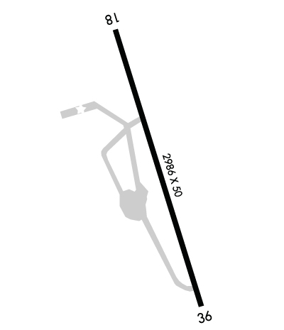
Runway Identifications
Runway Identification: 18/36
Length: 2986 ft
Width: 50 ft
Surface: ASPHALT-FAIR CONDITION
Edge lights: Non-Standard Lighting System

Treatment: NONE

 Runway: 18   Runway: 36
Mag heading: 180°Mag heading: 360°
Rwy Slope: -.57% DownRwy Slope: .57% Up
Approach: Approach:
Pattern: Left TrafficPattern: Left Traffic
Markings: BASICMarkings: BASIC
Marking Condition: GOODMarking Condition: GOOD
Arresting Dev: Arresting Dev:
Lat & Long: N4131.2  W07515.2Lat. & Long.: N4130.7  W07515.0
Elev: 1346.0 ft. MSLElev: 1329.0 ft. MSL
TCH: TCH:
Visual Glide Path: Visual Glide Path:
Displaced Threshold: 519 feetDisplaced Threshold: 589 feet
Touchdown Zone: YESTouchdown Zone: YES
Touchdown Elev.: 1348.0 feetTouchdown Elev.: 1348.0 feet
Visual Glide Slope: Visual Glide Slope:
RVR Equipment: RVR Equipment:
RVV Equipment: NORVV Equipment: NO
Approach Lights: Approach Lights:
REIL: NOREIL: NO
Centerline Lights: NOCenterline Lights: NO
Touchdown lights: NOTouchdown lights: NO
Runway Category: Runway with a Visual ApproachRunway Category: Runway with a Visual Approach
Declared Distances: Declared Distances:
Obstructions: TREEObstructions: TREE
Marked: NOT Marked/LightedMarked: NOT Marked/Lighted
Clearance slope: 12:1; APCH RATIO 21:1 TO DTHR.Clearance slope: 1:1; APCH RATIO 17:1 TO DTHR.
Obstruction height: 84 feet AGLObstruction height: 48 feet AGL
Dist. from runway: 1270 feetDist. from runway: 259 feet
Centerline offset: 224 left of centerlineCenterline offset: 110 feet left of centerline
Comments: RWY 18: 8 FT TREES/BRUSH, 52 FT OUT, 50 FT L AND R OF CNTRLN.Comments:
C:1/P: