| |||||||||||||||||||||||||||||||||||||||||||||||||||||||||||||||||||||
| |||||||||||||||||||||||||||||||||||||||||||||||||||||||||||||||||||||
| Rwy | Rwy | |||||||
| 3200x60 | 3200' | 3200x60 | 3200' | |||||
| Runway ID | Single Wheel | Double Wheel | Double Tandem Wheel | Dual Double Wheel |
| 09/27 | 12,500 | N/A | N/A | N/A |
| These numbers are Advisory and are not limits. The Airport Manager should have more accurate Weight Limits | ||||
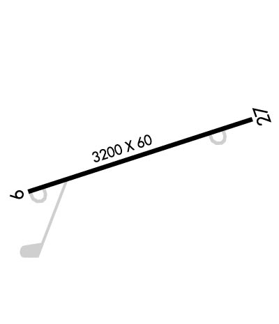 Airport Diagram might not be current. | |
| Facility Name: | BLOOMSBURG MUNI |
| City Name: | BLOOMSBURG |
| County: | COLUMBIA |
| State abbrev: | PA |
| State Name: | PENNSYLVANIA |
| Ownership: | PUBLICLY OWNED |
| Use: | OPEN TO THE PUBLIC |
| Owner's Name: | TOWN OF BLOOMSBURG |
| Address: | BLOOMSBURG TOWN HALL, 301 E 2ND ST |
| BLOOMSBURG, PA 17815-9588 | |
| Owner's Phone: | (570) 784-7123 |
| Manager's Name: | BJ TEICHMAN |
| Address: | 301 AIRPORT ROAD |
| BLOOMSBURG, PA 17815-9588 | |
| Phone: | (570) 317-2481 |
| FAA Region: | EASTERN |
| FAA Field Office: | HAR |
| Date | Sunrise | Sunset |
|---|---|---|
| 04/24/24 Wednesday | 6:12 | 19:56 |
| 04/25/24 Thursday | 6:11 | 19:57 |
| 04/26/24 Friday | 6:09 | 19:58 |
| 04/27/24 Saturday | 6:08 | 19:59 |
| 04/28/24 Sunday | 6:07 | 20:00 |
| 04/29/24 Monday | 6:05 | 20:01 |
| 04/30/24 Tuesday | 6:04 | 20:02 |
| 05/01/24 Wednesday | 6:03 | 20:03 |
| 05/02/24 Thursday | 6:02 | 20:04 |
| 05/03/24 Friday | 6:00 | 20:05 |
| 05/04/24 Saturday | 5:59 | 20:06 |
| 05/05/24 Sunday | 5:58 | 20:07 |
| 05/06/24 Monday | 5:57 | 20:08 |
| 05/07/24 Tuesday | 5:56 | 20:10 |
| Airport Attendance Schedule | MON-FRI 0830-1630, SAT-SUN IRREGULAR; FOR SVC AFT HRS CALL 570-317-1966. |
| Airport Status | OPERATIONAL (This Status can change at any time - please check NOTAMS) |
| Airport Lighting Schedule | ACTVT MIRL RWY 09/27- CTAF. |
| Airport Storage Available | Tie Downs |
| Extra Services Available | Flight Instruction |
| Wind Indicator | YES - (unlit) |
| Control Tower | NO |
| CTAF Frequency | 122.800 |
| Unicom Frequency | 122.800 |
| Rotating Beacon Color | WG |
| Segmented Circle | NO |
| Landing Fee | NO |
| Airport Inspected | STATE - performed by STATE AERONAUTICAL PERSONNEL |
| Inspection Date | 07/26/2023 |
| Type of Fuel Available | Grade 100LL |
| Airframe Repair Service | MAJOR |
| Power Plant Repair Service | MAJOR |
| Latitude | N4059.9 |
| Longitude | W07626.1 (ESTIMATED) |
| Arpt Elevation | 481ft (SURVEYED) |
| Magnetic Variation | 12W |
| 0 miles E | of BLOOMSBURG |
| Traffic Pattern Altitude | |
| Sectional Chart | NEW YORK |
| Operations (Reported) | Yearly | Avg. Daily |
|---|---|---|
| General Aviation Transient | 5500 | 15 |
| General Aviation Local | 9500 | 26 |
| Air Taxi | 50 | 0 |
| Commerical | 0 | 0 |
| Commuter | 0 | 0 |
| Military | 50 | 0 |
| Aircraft based on Field | |
|---|---|
| General Aviation Singles | 14 |
| General Aviation Multi | 1 |
| Jet Aircraft | 1 |
| General Aviation Helicopters | 1 |
| Military Aircraft | 0 |
| Gliders | 0 |
| Ultralights | 0 |
| FSS on field | NO |
| FSS tie-in | WILLIAMSPORT |
| FSS Phone | 1-800-WX-BRIEF |
| Who issues Notams | IPT |
| Notam D service at airport | YES |
| ARTCC Name | NEW YORK |
| Airport Certification | |
| Aircraft Rescue & Firefighting Index | None |
| Airport of Entry | No |
| Custom Landing Rights | No |
| Joint Civil/Military | No |
| Military Landing rights | YES |
| NATIONAL PLAN OF INTEGRATED AIRPORT SYSTEMS (NPIAS) |
| GRANT AGREEMENTS UNDER FAAP/ADAP/AIP |
| ASSURANCES PURSUANT TO TITLE VI, CIVIL RIGHTS ACT OF 1964 |
| DEER AND GEESE INVOF RWY. AFT DUSK, RWY 9 PREF DUE TO DEER ACT EAST END OF ARPT |
| FOR CD CTC WILKES-BARRE APCH AT 570-655-2084. |
Airport Communications & Frequencies:
| ||||||||||||||
| Runway: 09 | Runway: 27 | ||
| Mag heading: | 89° | Mag heading: | 269° |
| Rwy Slope: | .00% | Rwy Slope: | .00% |
| Approach: | Approach: | ||
| Pattern: | Left Traffic | Pattern: | Left Traffic |
| Markings: | BASIC | Markings: | BASIC |
| Marking Condition: | GOOD | Marking Condition: | GOOD |
| Arresting Dev: | Arresting Dev: | ||
| Lat & Long: | N4059.8 W07626.5 | Lat. & Long.: | N4059.9 W07625.8 |
| Elev: | 481.2 ft. MSL | Elev: | 481.2 ft. MSL |
| TCH: | TCH: | ||
| Visual Glide Path: | Visual Glide Path: | ||
| Displaced Threshold: | No | Displaced Threshold: | No |
| Touchdown Zone: | YES | Touchdown Zone: | YES |
| Touchdown Elev.: | 481.3 feet | Touchdown Elev.: | 481.3 feet |
| Visual Glide Slope: | Visual Glide Slope: | ||
| RVR Equipment: | RVR Equipment: | ||
| RVV Equipment: | NO | RVV Equipment: | NO |
| Approach Lights: | Approach Lights: | ||
| REIL: | NO | REIL: | NO |
| Centerline Lights: | NO | Centerline Lights: | NO |
| Touchdown lights: | NO | Touchdown lights: | NO |
| Runway Category: | Runway with a Visual Approach | Runway Category: | Runway with a Visual Approach |
| Declared Distances: | Declared Distances: | ||
| Obstructions: | TREES | Obstructions: | |
| Marked: | NOT Marked/Lighted | Marked: | |
| Clearance slope: | 14:1 | Clearance slope: | 20:1 |
| Obstruction height: | 47 feet AGL | Obstruction height: | |
| Dist. from runway: | 868 feet | Dist. from runway: | |
| Centerline offset: | 137 left of centerline | Centerline offset: | |
| Comments: | Comments: |