Current Weather/Notams (Metars, TAFs, Notams, NWS Forecast, PIREPS, and nearby weather)
Customs Information Send updates to Support@FltPlan.com
Customs Not Available
Database effective 05/16/2024
Airport Diagram might not be current.
|
| Facility Name: | LAUREL |
| City Name: | LAUREL |
| County: | SUSSEX |
| State abbrev: | DE |
| State Name: | DELAWARE |
| | |
| Ownership: | PRIVATELY OWNED |
| Use: | OPEN TO THE PUBLIC |
| Owner's Name: | DEST INC; DEST INC. |
| Address: | 106 STUART DRIVE |
| | DOVER, DE 19901 |
| Owner's Phone: | 302-697-6020 |
| | |
| Manager's Name: | JEFF CHORMAN |
| Address: | 30475 EAST MILL RUN |
| | MILTON, DE 19968 |
| Phone: | 302-349-5055 |
| | |
| FAA Region: | EASTERN |
| FAA Field Office: | HAR |
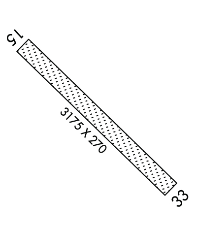
Runway Identifications
Runway Identification: 15/33Length: 3175 ft
Width: 270 ft
Surface: GRASS-GOOD CONDITION
Edge lights: Low IntensityTreatment: NONE
| | Runway: 15 | | Runway: 33 |
| Mag heading: | 148° | Mag heading: | 328° |
| Rwy Slope: | .04% Up | Rwy Slope: | -.04% Down |
| Approach: | | Approach: | |
| Pattern: | Left Traffic | Pattern: | Left Traffic |
| Markings: | | Markings: | |
| Marking Condition: | | Marking Condition: | DSPLCD THLD MKD WITH 3 LARGE ORANGE CONES EACH SIDE. |
| Arresting Dev: | | Arresting Dev: | |
| Lat & Long: | N3832.7 W07535.9 | Lat. & Long.: | N3832.4 W07535.4 |
| Elev: | 28.9 ft. MSL | Elev: | 30.1 ft. MSL |
| TCH: | | TCH: | |
| Visual Glide Path: | | Visual Glide Path: | |
| Displaced Threshold: | No | Displaced Threshold: | 270 feet |
| Touchdown Zone: | YES | Touchdown Zone: | YES |
| Touchdown Elev.: | 28.9 feet | Touchdown Elev.: | 30.1 feet |
| Visual Glide Slope: | | Visual Glide Slope: | |
| RVR Equipment: | | RVR Equipment: | |
| RVV Equipment: | NO | RVV Equipment: | NO |
| Approach Lights: | | Approach Lights: | |
| REIL: | NO | REIL: | NO |
| Centerline Lights: | NO | Centerline Lights: | NO |
| Touchdown lights: | NO | Touchdown lights: | NO |
| Runway Category: | Runway with a Visual Approach | Runway Category: | Runway with a Visual Approach |
| Declared Distances: | | Declared Distances: | |
| Obstructions: | TREES | Obstructions: | TREE |
| Marked: | NOT Marked/Lighted | Marked: | NOT Marked/Lighted |
| Clearance slope: | 1:1 | Clearance slope: | 1:1; RWY 33 APCH SLP 6:1 TO DSPLCD THLD. |
| Obstruction height: | 64 feet AGL | Obstruction height: | 60 feet AGL |
| Dist. from runway: | 90 feet | Dist. from runway: | 10 feet |
| Centerline offset: | 110 right of centerline | Centerline offset: | 167 feet right of centerline |
| Comments: | | Comments: | |

