Current Weather/Notams (Metars, TAFs, Notams, NWS Forecast, PIREPS, and nearby weather)
Customs Information Send updates to Support@FltPlan.com
Customs Not Available
Database effective 04/18/2024
Airport Diagram might not be current.
|
| Facility Name: | MINERAL WELLS RGNL |
| City Name: | MINERAL WELLS |
| County: | PARKER |
| State abbrev: | TX |
| State Name: | TEXAS |
| | |
| Ownership: | PUBLICLY OWNED |
| Use: | OPEN TO THE PUBLIC |
| Owner's Name: | CITY OF MINERAL WELLS |
| Address: | PO BOX 460 |
| | MINERAL WELLS, TX 76068 |
| Owner's Phone: | 940-328-7700 |
| | |
| Manager's Name: | HALEY CUEVAS |
| Address: | 5300 AIRPORT RD. |
| | MINERAL WELLS, TX 76067 |
| Phone: | 940-328-7809 |
| | |
| FAA Region: | SOUTHWEST |
| FAA Field Office: | TEX |
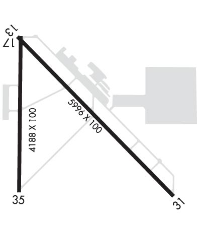
Runway Identifications
Runway Identification: 13/31Length: 5996 ft
Width: 100 ft
Surface: ASPHALT-GOOD CONDITION
Edge lights: Medium IntensityTreatment: NONE
| | Runway: 13 | | Runway: 31 |
| Mag heading: | 130° | Mag heading: | 310° |
| Rwy Slope: | .94% Up | Rwy Slope: | -.94% Down |
| Approach: | | Approach: | ILS/DME |
| Pattern: | Left Traffic | Pattern: | Left Traffic |
| Markings: | NONPRECISION INSTRUMENT | Markings: | PRECISION INSTRUMENT |
| Marking Condition: | FAIR | Marking Condition: | FAIR |
| Arresting Dev: | | Arresting Dev: | |
| Lat & Long: | N3247.2 W09803.9 | Lat. & Long.: | N3246.5 W09803.0 |
| Elev: | 913.0 ft. MSL | Elev: | 969.3 ft. MSL |
| TCH: | 40 ft. AGL | TCH: | 53 ft. AGL |
| Visual Glide Path: | 3.00 degrees | Visual Glide Path: | 3.00 degrees |
| Displaced Threshold: | 300 feet | Displaced Threshold: | 400 feet |
| Touchdown Zone: | YES | Touchdown Zone: | YES |
| Touchdown Elev.: | 947.2 feet | Touchdown Elev.: | 973.6 feet |
| Visual Glide Slope: | 4-Light PAPI on LEFT side of Runway | Visual Glide Slope: | 4-Light PAPI on LEFT side of Runway |
| RVR Equipment: | | RVR Equipment: | |
| RVV Equipment: | NO | RVV Equipment: | NO |
| Approach Lights: | | Approach Lights: | |
| REIL: | NO | REIL: | NO |
| Centerline Lights: | NO | Centerline Lights: | NO |
| Touchdown lights: | NO | Touchdown lights: | NO |
| Runway Category: | Runway with a Visual Approach | Runway Category: | Precision Instrument Runway |
| Declared Distances: | | Declared Distances: | |
| Obstructions: | FENCE | Obstructions: | TREES |
| Marked: | NOT Marked/Lighted | Marked: | NOT Marked/Lighted |
| Clearance slope: | 1:1; RAPCH SLOPE AT DSPLCD THLD 22:1 OVR 28 FT TREE 630 FT DSTC 316 FT R. | Clearance slope: | 1:1; APCH SLOPE 0:1 TO DSPLCD THR OVR FT GND 0 FT DSTC, 180 FT LEFT. |
| Obstruction height: | 8 feet AGL | Obstruction height: | 35 feet AGL |
| Dist. from runway: | 201 feet | Dist. from runway: | 201 feet |
| Centerline offset: | 345 right of centerline | Centerline offset: | 435 feet left of centerline |
| Comments: | 8 FT FENCE, 199 FT DSTC, 347 FT R, 15 FT RD, 199 FT DSTC, 390 FT R. | Comments: | 10 FT GND 0-199 DSTC 150-200 FT L. |
Runway Identification: 17/35Length: 4188 ft
Width: 100 ft
Surface: ASPHALT-GOOD CONDITION
Edge lights: Medium IntensityTreatment: NONE
| | Runway: 17 | | Runway: 35 |
| Mag heading: | 175° | Mag heading: | 355° |
| Rwy Slope: | 1.00% Up | Rwy Slope: | -1.00% Down |
| Approach: | | Approach: | |
| Pattern: | Left Traffic | Pattern: | Left Traffic |
| Markings: | BASIC | Markings: | BASIC |
| Marking Condition: | FAIR | Marking Condition: | FAIR |
| Arresting Dev: | | Arresting Dev: | |
| Lat & Long: | N3247.2 W09803.8 | Lat. & Long.: | N3246.6 W09803.8 |
| Elev: | 913.9 ft. MSL | Elev: | 955.7 ft. MSL |
| TCH: | 43 ft. AGL | TCH: | 46 ft. AGL |
| Visual Glide Path: | 3.00 degrees | Visual Glide Path: | 4.00 degrees |
| Displaced Threshold: | No | Displaced Threshold: | 286 feet |
| Touchdown Zone: | YES | Touchdown Zone: | YES |
| Touchdown Elev.: | 944.7 feet | Touchdown Elev.: | 954.1 feet |
| Visual Glide Slope: | 2-Light PAPI on RIGHT side of Runway | Visual Glide Slope: | 2-Light PAPI on LEFT side of Runway; PAPI UNUSBL BYD 3 DEG L OF CNTRLN. |
| RVR Equipment: | | RVR Equipment: | |
| RVV Equipment: | NO | RVV Equipment: | NO |
| Approach Lights: | | Approach Lights: | |
| REIL: | NO | REIL: | NO |
| Centerline Lights: | NO | Centerline Lights: | NO |
| Touchdown lights: | NO | Touchdown lights: | NO |
| Runway Category: | Runway with a Visual Approach | Runway Category: | Runway with a Visual Approach |
| Declared Distances: | | Declared Distances: | |
| Obstructions: | TREES | Obstructions: | TREES |
| Marked: | NOT Marked/Lighted | Marked: | NOT Marked/Lighted |
| Clearance slope: | 10:1 | Clearance slope: | 3:1; APCH SLOPE 9:1 TO DSPLCD THR. |
| Obstruction height: | 35 feet AGL | Obstruction height: | 80 feet AGL |
| Dist. from runway: | 556 feet | Dist. from runway: | 500 feet |
| Centerline offset: | 20 left of centerline | Centerline offset: | 385 feet left of centerline |
| Comments: | | Comments: | |

