Current Weather/Notams (Metars, TAFs, Notams, NWS Forecast, PIREPS, and nearby weather)
Customs Information Send updates to Support@FltPlan.com
Customs Not Available
Database effective 05/16/2024
Airport Diagram might not be current.
|
| Facility Name: | LAWRENCE J TIMMERMAN |
| City Name: | MILWAUKEE |
| County: | MILWAUKEE |
| State abbrev: | WI |
| State Name: | WISCONSIN |
| | |
| Ownership: | PUBLICLY OWNED |
| Use: | OPEN TO THE PUBLIC |
| Owner's Name: | MILWAUKEE COUNTY |
| Address: | COUNTY COURTHOUSE |
| | MILWAUKEE, WI 53233 |
| Owner's Phone: | 414-747-5300 |
| | |
| Manager's Name: | BRIAN DRANZIK |
| Address: | 5300 S HOWELL; EMAIL ADDRESS: BDRANZIK@MITCHELLAIRPORT.COM (ALL LOWER CASE) |
| | MILWAUKEE, WI 53207 |
| Phone: | 414-747-5300 |
| | |
| FAA Region: | GREAT LAKES |
| FAA Field Office: | CHI |
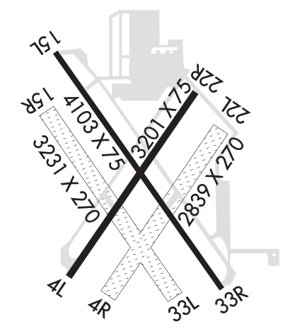
Runway Identifications
Runway Identification: 04L/22RLength: 3203 ft
Width: 75 ft
Surface: ASPHALT
Edge lights: Medium IntensityTreatment: NONE
| | Runway: 04L | | Runway: 22R |
| Mag heading: | 38° | Mag heading: | 218° |
| Rwy Slope: | .04% Up | Rwy Slope: | -.04% Down |
| Approach: | | Approach: | |
| Pattern: | Left Traffic | Pattern: | Left Traffic |
| Markings: | NONPRECISION INSTRUMENT | Markings: | NONPRECISION INSTRUMENT |
| Marking Condition: | GOOD | Marking Condition: | GOOD |
| Arresting Dev: | | Arresting Dev: | |
| Lat & Long: | N4306.4 W08802.3 | Lat. & Long.: | N4306.9 W08801.9 |
| Elev: | 737.2 ft. MSL | Elev: | 738.4 ft. MSL |
| TCH: | 44 ft. AGL | TCH: | 45 ft. AGL |
| Visual Glide Path: | 4.00 degrees | Visual Glide Path: | 4.00 degrees |
| Displaced Threshold: | No | Displaced Threshold: | No |
| Touchdown Zone: | YES | Touchdown Zone: | YES |
| Touchdown Elev.: | 738.0 feet | Touchdown Elev.: | 738.4 feet |
| Visual Glide Slope: | 4-BOX VASI ON LEFT SIDE OF RUNWAY; WHEN VASI OTS, RWY CLSD TO LDG SS-SR. | Visual Glide Slope: | 4-BOX VASI ON LEFT SIDE OF RUNWAY; WHEN VASI OTS, RWY CLSD TO LDG SS-SR. |
| RVR Equipment: | | RVR Equipment: | |
| RVV Equipment: | NO | RVV Equipment: | NO |
| Approach Lights: | | Approach Lights: | |
| REIL: | YES | REIL: | YES |
| Centerline Lights: | NO | Centerline Lights: | NO |
| Touchdown lights: | NO | Touchdown lights: | NO |
| Runway Category: | Runway with a Non-precision Approach | Runway Category: | Runway with a Non-precision Approach |
| Declared Distances: | | Declared Distances: | |
| Obstructions: | | Obstructions: | TREE |
| Marked: | | Marked: | NOT Marked/Lighted |
| Clearance slope: | 20:1 | Clearance slope: | 17:1 |
| Obstruction height: | | Obstruction height: | 29 feet AGL |
| Dist. from runway: | | Dist. from runway: | 700 feet |
| Centerline offset: | | Centerline offset: | 250 feet left of centerline |
| Comments: | | Comments: | |
Runway Identification: 04R/22LLength: 2840 ft
Width: 270 ft
Surface: GRASS-GOOD CONDITION
Edge lights: Treatment: NONE
| | Runway: 04R | | Runway: 22L |
| Mag heading: | 38° | Mag heading: | 218° |
| Rwy Slope: | .15% Up | Rwy Slope: | -.15% Down |
| Approach: | | Approach: | |
| Pattern: | Left Traffic | Pattern: | Left Traffic |
| Markings: | | Markings: | |
| Marking Condition: | MKD BY WHITE TFC CONES. | Marking Condition: | MKD BY WHITE TFC CONES. |
| Arresting Dev: | | Arresting Dev: | |
| Lat & Long: | N4306.4 W08802.2 | Lat. & Long.: | N4306.8 W08801.8 |
| Elev: | 732.0 ft. MSL | Elev: | 736.4 ft. MSL |
| TCH: | | TCH: | |
| Visual Glide Path: | | Visual Glide Path: | |
| Displaced Threshold: | No | Displaced Threshold: | No |
| Touchdown Zone: | YES | Touchdown Zone: | YES |
| Touchdown Elev.: | 736.4 feet | Touchdown Elev.: | 736.4 feet |
| Visual Glide Slope: | | Visual Glide Slope: | |
| RVR Equipment: | | RVR Equipment: | |
| RVV Equipment: | NO | RVV Equipment: | NO |
| Approach Lights: | | Approach Lights: | |
| REIL: | NO | REIL: | NO |
| Centerline Lights: | NO | Centerline Lights: | NO |
| Touchdown lights: | NO | Touchdown lights: | NO |
| Runway Category: | Runway with a Visual Approach | Runway Category: | Runway with a Visual Approach |
| Declared Distances: | | Declared Distances: | |
| Obstructions: | TREES | Obstructions: | TREES |
| Marked: | NOT Marked/Lighted | Marked: | NOT Marked/Lighted |
| Clearance slope: | 14:1 | Clearance slope: | 15:1 |
| Obstruction height: | 50 feet AGL | Obstruction height: | 53 feet AGL |
| Dist. from runway: | 915 feet | Dist. from runway: | 800 feet |
| Centerline offset: | | Centerline offset: | 150 feet left of centerline |
| Comments: | | Comments: | |
Runway Identification: 15L/33RLength: 4107 ft
Width: 75 ft
Surface: ASPHALT
Edge lights: Medium IntensityTreatment: NONE
| | Runway: 15L | | Runway: 33R |
| Mag heading: | 148° | Mag heading: | 328° |
| Rwy Slope: | -.01% Down | Rwy Slope: | .01% Up |
| Approach: | LOCALIZER | Approach: | |
| Pattern: | Left Traffic | Pattern: | Left Traffic |
| Markings: | NONPRECISION INSTRUMENT | Markings: | NONPRECISION INSTRUMENT |
| Marking Condition: | GOOD | Marking Condition: | GOOD |
| Arresting Dev: | | Arresting Dev: | |
| Lat & Long: | N4306.9 W08802.3 | Lat. & Long.: | N4306.4 W08801.8 |
| Elev: | 744.1 ft. MSL | Elev: | 743.7 ft. MSL |
| TCH: | 41 ft. AGL | TCH: | 40 ft. AGL |
| Visual Glide Path: | 3.00 degrees | Visual Glide Path: | 4.00 degrees |
| Displaced Threshold: | No | Displaced Threshold: | No |
| Touchdown Zone: | YES | Touchdown Zone: | YES |
| Touchdown Elev.: | 744.8 feet | Touchdown Elev.: | 743.7 feet |
| Visual Glide Slope: | 4-Light PAPI on RIGHT side of Runway | Visual Glide Slope: | 4-Light PAPI on LEFT side of Runway; UNUSBL BYD 8 DEGS RIGHT OF CNTRLN. WHEN PAPI OTS, RWY CLSD TO LDG SS-SR. |
| RVR Equipment: | | RVR Equipment: | |
| RVV Equipment: | NO | RVV Equipment: | NO |
| Approach Lights: | | Approach Lights: | |
| REIL: | YES | REIL: | YES |
| Centerline Lights: | NO | Centerline Lights: | NO |
| Touchdown lights: | NO | Touchdown lights: | NO |
| Runway Category: | Runway with a Non-precision Approach having visibility minimums greater than 3/4 mile | Runway Category: | Runway with a Visual Approach |
| Declared Distances: | | Declared Distances: | |
| Obstructions: | | Obstructions: | TREE |
| Marked: | | Marked: | NOT Marked/Lighted |
| Clearance slope: | 34:1 | Clearance slope: | 18:1 |
| Obstruction height: | | Obstruction height: | 35 feet AGL |
| Dist. from runway: | | Dist. from runway: | 830 feet |
| Centerline offset: | | Centerline offset: | 25 feet right of centerline |
| Comments: | | Comments: | |
Runway Identification: 15R/33LLength: 3231 ft
Width: 270 ft
Surface: GRASS-GOOD CONDITION
Edge lights: Treatment: NONE
| | Runway: 15R | | Runway: 33L |
| Mag heading: | 147° | Mag heading: | 327° |
| Rwy Slope: | -.28% Down | Rwy Slope: | .28% Up |
| Approach: | | Approach: | |
| Pattern: | Left Traffic | Pattern: | Left Traffic |
| Markings: | | Markings: | |
| Marking Condition: | MKD BY WHITE TFC CONES. | Marking Condition: | MKD BY WHITE TFC CONES. |
| Arresting Dev: | | Arresting Dev: | |
| Lat & Long: | N4306.8 W08802.4 | Lat. & Long.: | N4306.4 W08801.9 |
| Elev: | 742.3 ft. MSL | Elev: | 733.3 ft. MSL |
| TCH: | | TCH: | |
| Visual Glide Path: | | Visual Glide Path: | |
| Displaced Threshold: | No | Displaced Threshold: | No |
| Touchdown Zone: | YES | Touchdown Zone: | YES |
| Touchdown Elev.: | 742.5 feet | Touchdown Elev.: | 742.2 feet |
| Visual Glide Slope: | | Visual Glide Slope: | |
| RVR Equipment: | | RVR Equipment: | |
| RVV Equipment: | NO | RVV Equipment: | NO |
| Approach Lights: | | Approach Lights: | |
| REIL: | NO | REIL: | NO |
| Centerline Lights: | NO | Centerline Lights: | NO |
| Touchdown lights: | NO | Touchdown lights: | NO |
| Runway Category: | Runway with a Visual Approach | Runway Category: | Runway with a Visual Approach |
| Declared Distances: | | Declared Distances: | |
| Obstructions: | | Obstructions: | TREE |
| Marked: | | Marked: | NOT Marked/Lighted |
| Clearance slope: | 20:1 | Clearance slope: | 16:1 |
| Obstruction height: | | Obstruction height: | 50 feet AGL |
| Dist. from runway: | | Dist. from runway: | 800 feet |
| Centerline offset: | | Centerline offset: | 50 feet left of centerline |
| Comments: | | Comments: | |

