Current Weather/Notams (Metars, TAFs, Notams, NWS Forecast, PIREPS, and nearby weather)
Customs Information Send updates to Support@FltPlan.com
Customs Not Available
Database effective 05/16/2024
Airport Diagram might not be current.
|
| Facility Name: | VETERANS AIRPORT OF SOUTHERN ILLINOIS |
| City Name: | MARION |
| County: | WILLIAMSON |
| State abbrev: | IL |
| State Name: | ILLINOIS |
| | |
| Ownership: | PUBLICLY OWNED |
| Use: | OPEN TO THE PUBLIC |
| Owner's Name: | WILLIAMSON COUNTY ARPT AUTH |
| Address: | 10400 TERMINAL DR |
| | MARION, IL 62959 |
| Owner's Phone: | 618-993-3353 |
| | |
| Manager's Name: | DOUGLAS S KIMMEL |
| Address: | 10400 TERMINAL DR; SUITE 200; EMAIL ADDRESS: AIRPORT1@MIDWEST.NET (ALL LOWER CASE) |
| | MARION, IL 62959 |
| Phone: | 618-993-3353; M-F 1500-2300Z 618-993-3353; AFT HR- 618-889-3900. |
| | |
| FAA Region: | GREAT LAKES |
| FAA Field Office: | CHI |
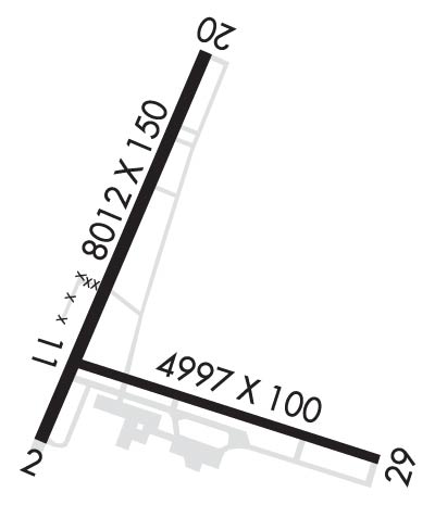
Runway Identifications
Runway Identification: 02/20Length: 8012 ft
Width: 150 ft
Surface: ASPHALT-GOOD CONDITION
Edge lights: High IntensityTreatment: POROUS FRICTION COURSE
Weight: PCN 25 /F/C/X/U
| | Runway: 02 | | Runway: 20 |
| Mag heading: | 21° | Mag heading: | 201° |
| Rwy Slope: | .16% Up | Rwy Slope: | -.16% Down |
| Approach: | | Approach: | ILS |
| Pattern: | Left Traffic | Pattern: | Left Traffic |
| Markings: | PRECISION INSTRUMENT | Markings: | PRECISION INSTRUMENT |
| Marking Condition: | FAIR | Marking Condition: | FAIR |
| Arresting Dev: | | Arresting Dev: | |
| Lat & Long: | N3744.9 W08901.1 | Lat. & Long.: | N3746.1 W08900.4 |
| Elev: | 452.6 ft. MSL | Elev: | 465.4 ft. MSL |
| TCH: | 36 ft. AGL | TCH: | |
| Visual Glide Path: | 3.50 degrees | Visual Glide Path: | |
| Displaced Threshold: | No | Displaced Threshold: | No |
| Touchdown Zone: | YES | Touchdown Zone: | YES |
| Touchdown Elev.: | 466.3 feet | Touchdown Elev.: | 467.6 feet |
| Visual Glide Slope: | 4-Light PAPI on LEFT side of Runway | Visual Glide Slope: | |
| RVR Equipment: | | RVR Equipment: | |
| RVV Equipment: | NO | RVV Equipment: | NO |
| Approach Lights: | | Approach Lights: | MALSR - 1,400 foot medium intensity approach lighting system with runway alignment indicator lights |
| REIL: | YES | REIL: | NO |
| Centerline Lights: | NO | Centerline Lights: | NO |
| Touchdown lights: | NO | Touchdown lights: | NO |
| Runway Category: | D | Runway Category: | Precision Instrument Runway |
| Declared Distances: | TORA:8012' TODA:8012' ASDA:8012' LDA:8012' | Declared Distances: | TORA:8012' TODA:8012' ASDA:8012' LDA:8012' |
| Obstructions: | TREES | Obstructions: | TREE |
| Marked: | NOT Marked/Lighted | Marked: | NOT Marked/Lighted |
| Clearance slope: | 34:1 | Clearance slope: | 33:1 |
| Obstruction height: | 56 feet AGL | Obstruction height: | 83 feet AGL |
| Dist. from runway: | 2130 feet | Dist. from runway: | 2945 feet |
| Centerline offset: | 697 left of centerline | Centerline offset: | 847 feet left of centerline |
| Comments: | | Comments: | |
Runway Identification: 11/29Length: 4997 ft
Width: 100 ft
Surface: CONCRETE ASPHALT
Edge lights: Medium IntensityTreatment: GROOVED
Weight: PCN 15 /F/C/Y/U
| | Runway: 11 | | Runway: 29 |
| Mag heading: | 107° | Mag heading: | 287° |
| Rwy Slope: | .27% Up | Rwy Slope: | -.27% Down |
| Approach: | | Approach: | |
| Pattern: | Left Traffic | Pattern: | Left Traffic |
| Markings: | BASIC | Markings: | BASIC |
| Marking Condition: | FAIR | Marking Condition: | FAIR |
| Arresting Dev: | | Arresting Dev: | |
| Lat & Long: | N3745.1 W08901.0 | Lat. & Long.: | N3744.8 W08900.0 |
| Elev: | 453.7 ft. MSL | Elev: | 467.2 ft. MSL |
| TCH: | 26 ft. AGL | TCH: | 25 ft. AGL |
| Visual Glide Path: | 3.00 degrees | Visual Glide Path: | 3.00 degrees |
| Displaced Threshold: | No | Displaced Threshold: | No |
| Touchdown Zone: | YES | Touchdown Zone: | YES |
| Touchdown Elev.: | 471.7 feet | Touchdown Elev.: | 471.7 feet |
| Visual Glide Slope: | 4-Light PAPI on LEFT side of Runway | Visual Glide Slope: | 4-Light PAPI on LEFT side of Runway |
| RVR Equipment: | | RVR Equipment: | |
| RVV Equipment: | NO | RVV Equipment: | NO |
| Approach Lights: | | Approach Lights: | |
| REIL: | YES | REIL: | YES |
| Centerline Lights: | NO | Centerline Lights: | NO |
| Touchdown lights: | NO | Touchdown lights: | NO |
| Runway Category: | Runway with a Visual Approach | Runway Category: | Runway with a Visual Approach |
| Declared Distances: | TORA:4997' TODA:4997' ASDA:4997' LDA:4997' | Declared Distances: | TORA:4997' TODA:4997' ASDA:4997' LDA:4997' |
| Obstructions: | TREE | Obstructions: | SIGN |
| Marked: | NOT Marked/Lighted | Marked: | NOT Marked/Lighted |
| Clearance slope: | 21:1 | Clearance slope: | 33:1 |
| Obstruction height: | 62 feet AGL | Obstruction height: | 30 feet AGL |
| Dist. from runway: | 1537 feet | Dist. from runway: | 1218 feet |
| Centerline offset: | 90 left of centerline | Centerline offset: | 249 feet left of centerline |
| Comments: | | Comments: | |


