Current Weather/Notams (Metars, TAFs, Notams, NWS Forecast, PIREPS, and nearby weather)
Customs Information Send updates to Support@FltPlan.com
Customs Not Available
Database effective 05/16/2024
Airport Diagram might not be current.
|
| Facility Name: | MUSCATINE MUNI |
| City Name: | MUSCATINE |
| County: | MUSCATINE |
| State abbrev: | IA |
| State Name: | IOWA |
| | |
| Ownership: | PUBLICLY OWNED |
| Use: | OPEN TO THE PUBLIC |
| Owner's Name: | CITY OF MUSCATINE |
| Address: | 215 SYCAMORE |
| | MUSCATINE, IA 52761 |
| Owner's Phone: | 563-264-1550 |
| | |
| Manager's Name: | MIKE WOERLY |
| Address: | 5701 SOUTH HIGHWAY 61 |
| | MUSCATINE, IA 52761 |
| Phone: | 563-263-8672 |
| | |
| FAA Region: | CENTRAL |
| FAA Field Office: | NONE |
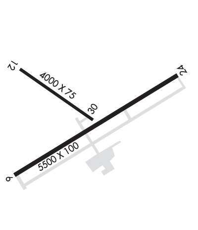
Runway Identifications
Runway Identification: 06/24Length: 5500 ft
Width: 100 ft
Surface: CONCRETE-GOOD CONDITION
Edge lights: Medium IntensityTreatment: GROOVED
Weight: PCN 20 /R/C/W/T
| | Runway: 06 | | Runway: 24 |
| Mag heading: | 59° | Mag heading: | 240° |
| Rwy Slope: | -.06% Down | Rwy Slope: | .06% Up |
| Approach: | | Approach: | ILS/DME |
| Pattern: | Left Traffic | Pattern: | Left Traffic |
| Markings: | NONPRECISION INSTRUMENT | Markings: | PRECISION INSTRUMENT |
| Marking Condition: | FAIR | Marking Condition: | FAIR |
| Arresting Dev: | | Arresting Dev: | |
| Lat & Long: | N4121.7 W09109.3 | Lat. & Long.: | N4122.2 W09108.2 |
| Elev: | 544.7 ft. MSL | Elev: | 541.4 ft. MSL |
| TCH: | 37 ft. AGL | TCH: | 52 ft. AGL |
| Visual Glide Path: | 3.00 degrees | Visual Glide Path: | 3.00 degrees |
| Displaced Threshold: | No | Displaced Threshold: | No |
| Touchdown Zone: | YES | Touchdown Zone: | YES |
| Touchdown Elev.: | 547.2 feet | Touchdown Elev.: | 544.7 feet |
| Visual Glide Slope: | 4-BOX VASI ON LEFT SIDE OF RUNWAY | Visual Glide Slope: | 4-Light PAPI on RIGHT side of Runway |
| RVR Equipment: | | RVR Equipment: | |
| RVV Equipment: | NO | RVV Equipment: | NO |
| Approach Lights: | | Approach Lights: | MALSR - 1,400 foot medium intensity approach lighting system with runway alignment indicator lights |
| REIL: | YES | REIL: | NO |
| Centerline Lights: | NO | Centerline Lights: | NO |
| Touchdown lights: | NO | Touchdown lights: | NO |
| Runway Category: | Runway with a Non-precision Approach having visibility minimums greater than 3/4 mile | Runway Category: | Precision Instrument Runway |
| Declared Distances: | | Declared Distances: | |
| Obstructions: | TREE | Obstructions: | |
| Marked: | NOT Marked/Lighted | Marked: | |
| Clearance slope: | 24:1 | Clearance slope: | 50:1 |
| Obstruction height: | 77 feet AGL | Obstruction height: | |
| Dist. from runway: | 2097 feet | Dist. from runway: | |
| Centerline offset: | 102 left of centerline | Centerline offset: | |
| Comments: | | Comments: | |
Runway Identification: 12/30Length: 4000 ft
Width: 75 ft
Surface: CONCRETE-GOOD CONDITION
Edge lights: Medium IntensityTreatment: GROOVED
Weight: PCN 9 /R/C/W/T
| | Runway: 12 | | Runway: 30 |
| Mag heading: | 126° | Mag heading: | 306° |
| Rwy Slope: | .18% Up | Rwy Slope: | -.18% Down |
| Approach: | | Approach: | |
| Pattern: | Left Traffic | Pattern: | Left Traffic |
| Markings: | NONPRECISION INSTRUMENT | Markings: | NONPRECISION INSTRUMENT |
| Marking Condition: | FAIR | Marking Condition: | FAIR |
| Arresting Dev: | | Arresting Dev: | |
| Lat & Long: | N4122.4 W09109.4 | Lat. & Long.: | N4122.0 W09108.7 |
| Elev: | 535.8 ft. MSL | Elev: | 543.1 ft. MSL |
| TCH: | 44 ft. AGL | TCH: | 40 ft. AGL |
| Visual Glide Path: | 3.00 degrees | Visual Glide Path: | 3.00 degrees |
| Displaced Threshold: | No | Displaced Threshold: | No |
| Touchdown Zone: | YES | Touchdown Zone: | YES |
| Touchdown Elev.: | 541.0 feet | Touchdown Elev.: | 543.1 feet |
| Visual Glide Slope: | 4-Light PAPI on LEFT side of Runway | Visual Glide Slope: | 4-Light PAPI on LEFT side of Runway |
| RVR Equipment: | | RVR Equipment: | |
| RVV Equipment: | NO | RVV Equipment: | NO |
| Approach Lights: | | Approach Lights: | |
| REIL: | YES | REIL: | YES |
| Centerline Lights: | NO | Centerline Lights: | NO |
| Touchdown lights: | NO | Touchdown lights: | NO |
| Runway Category: | Runway with a Non-precision Approach having visibility minimums greater than 3/4 mile | Runway Category: | Runway with a Non-precision Approach having visibility minimums greater than 3/4 mile |
| Declared Distances: | | Declared Distances: | |
| Obstructions: | TREE | Obstructions: | |
| Marked: | NOT Marked/Lighted | Marked: | |
| Clearance slope: | 19:1 | Clearance slope: | 50:1 |
| Obstruction height: | 8 feet AGL | Obstruction height: | |
| Dist. from runway: | 353 feet | Dist. from runway: | |
| Centerline offset: | 13 right of centerline | Centerline offset: | |
| Comments: | | Comments: | |

