
| ||||||||||||||||||||||||||||||||
| ||||||||||||||||||||||||||||||||
| ||||||||||||||||||||||||||||||||
| Rwy | Rwy | |||||||
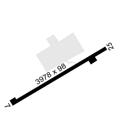
| 3981x98 | 3631' | 3981x98 | 3860' | 111.75 - 239° | ||||
| Runway ID | Single Wheel | Double Wheel | Double Tandem Wheel | Dual Double Wheel |
| 07/25 | N/A | N/A | N/A | N/A |
| H1 | N/A | N/A | N/A | N/A |
| H2 | N/A | N/A | N/A | N/A |
| H3 | N/A | N/A | N/A | N/A |
| These numbers are Advisory and are not limits. The Airport Manager should have more accurate Weight Limits | ||||
 Airport Diagram might not be current. | |
| Facility Name: | MUIR AHP (FORT INDIANTOWN GAP) |
| City Name: | FORT INDIANTOWN GAP (ANNVILLE) |
| County: | LEBANON |
| State abbrev: | PA |
| State Name: | PENNSYLVANIA |
| Ownership: | ARMY OWNED |
| Use: | PRIVATE |
| Owner's Name: | US ARMY ATCA-ASO |
| Address: | CAMERON STA |
| ALEXANDRIA, VA 22314 | |
| Owner's Phone: | |
| Manager's Name: | AIRFIELD OPS |
| Address: | |
| Phone: | 717-861-8963 |
| FAA Region: | EASTERN |
| FAA Field Office: | HAR |
| Date | Sunrise | Sunset |
|---|---|---|
| 04/22/24 Monday | 6:17 | 19:53 |
| 04/23/24 Tuesday | 6:15 | 19:54 |
| 04/24/24 Wednesday | 6:14 | 19:55 |
| 04/25/24 Thursday | 6:12 | 19:56 |
| 04/26/24 Friday | 6:11 | 19:58 |
| 04/27/24 Saturday | 6:10 | 19:59 |
| 04/28/24 Sunday | 6:08 | 20:00 |
| 04/29/24 Monday | 6:07 | 20:01 |
| 04/30/24 Tuesday | 6:06 | 20:02 |
| 05/01/24 Wednesday | 6:05 | 20:03 |
| 05/02/24 Thursday | 6:03 | 20:04 |
| 05/03/24 Friday | 6:02 | 20:05 |
| 05/04/24 Saturday | 6:01 | 20:06 |
| 05/05/24 Sunday | 6:00 | 20:07 |
| Airport Attendance Schedule | 1 APR-31 OCT MON-FRI 1400-0500Z++, 1 NOV-31 MAR MON-FRI 1300-0300Z++; OPEN ADDN HR FOR SKED TRNG. SEE FLIP AP/1 SUPPLEMENTARY ARPT |
| Airport Status | OPERATIONAL (This Status can change at any time - please check NOTAMS) |
| Airport Lighting Schedule | MIRL RWY 07/25 ATCT-CTL. ACTVT PAPI RWY 25 - CTAF; MIRL RWY 07/25 ATCT. |
| Airport Storage Available | NONE |
| Extra Services Available | NONE |
| Wind Indicator | YES - (unlit) |
| Control Tower | YES |
| CTAF Frequency | 126.200 |
| Unicom Frequency | |
| Rotating Beacon Color | SWG |
| Segmented Circle | NO |
| Landing Fee |
| Airport Inspected | No Inspection Data Available performed by the OWNER |
| Inspection Date | Unknown |
| Type of Fuel Available | None |
| Airframe Repair Service | None |
| Power Plant Repair Service | None |
| Latitude | N4026.1 |
| Longitude | W07634.1 (ESTIMATED) |
| Arpt Elevation | 487ft (SURVEYED) |
| Magnetic Variation | 10W |
| 6 miles N | of FORT INDIANTOWN GAP (ANNVILLE) |
| Traffic Pattern Altitude | |
| Sectional Chart | NEW YORK |
| Operations (Reported) | Yearly | Avg. Daily |
|---|---|---|
| General Aviation Transient | 0 | 0 |
| General Aviation Local | 0 | 0 |
| Air Taxi | 0 | 0 |
| Commerical | 0 | 0 |
| Commuter | 0 | 0 |
| Military | 0 | 0 |
| Aircraft based on Field | |
|---|---|
| General Aviation Singles | 0 |
| General Aviation Multi | 0 |
| Jet Aircraft | 0 |
| General Aviation Helicopters | 0 |
| Military Aircraft | 0 |
| Gliders | 0 |
| Ultralights | 0 |
| FSS on field | NO |
| FSS tie-in | WILLIAMSPORT |
| FSS Phone | 1-800-WX-BRIEF |
| Who issues Notams | IPT |
| Notam D service at airport | YES |
| ARTCC Name | NEW YORK |
| Airport Certification | |
| Aircraft Rescue & Firefighting Index | None |
| Airport of Entry | No |
| Custom Landing Rights | No |
| Joint Civil/Military | No |
| Military Landing rights | No |
| FUEL: J8 - PPR, 24 HR WKD, 48 HR WKEND, FOR FUEL AND PRK THRU ARNG OPS C717-861-8963, DSN 491-8963. |
| RSTD: PPR 24 HR WKD 48 HR WKEND. PPR ALL TRAN ACFT. CTC OPS DSN 491-8963, C717-861-8963. |
| CAUTION: RWY HAS GRADUAL 30' RISE FR APCH END RWY 07 TO A PT 2800' UP RWY, RWY ENDS NOT MUTUALLY VIS. LGTD WATER TWR .7 NM W AND 0.5 NM S OF AFLD. |
| TFC PAT: R/W 1200' MSL. |
| FSS: WILLIAMSPORT IPT-NOTAM IPT |
| MISC: LTD PRK. |
| MISC: WX 1200-0300Z++ EXCLD WKEND AND HOL, OT CTC 15 OWS, SCOTT AFB, DSN 576-9755. 2 HR LEAD TIME RQR. |
| LGTD WATER TWR .7 NM W. |
| RSTD: PPR 24 HR, CALL DUR NML DUTY HR. PPR ALL TRAN ACFT. CTC OPS DSN 491-8963, C717-861-8963. |
| AIRFIELD CLSD ON WKENDS AND HOL. ANY ACFT ARRIVING OR DEPARTING ON WKENDS OR HOL REQUIRES PRIOR APVL. ACCESS TO AIRFIELD IS RSTD WHEN CLSD. CTC MUIR AHP OPS AT (717) 861-8963; DSN 491-8963. |
| FOR CD WHEN ATCT CLSD, CTC HARRISBURG APCH AT 800-932-0712. |
| RSTD: AUGMENTED/MAN VIS OBS FM 20 FT AGL. BLDG OBSTN MAY IMPACT PREVAILING VIS 270-020. |
| MISC: WX STN DSN 491-2536, C717-861-2536, AN/FMQ-19 ASOS IN USE. AUGMENTED WHEN NEC DRG WX STN HRS. |
| ECHO 5 PARKING PAD IS FOR VIP LOADING AND UNLOADING ONLY. |
| MISC: CLASS D AIRSPACE REVERTS TO CLASS G SFC-700 FT, CLASS E 700 FT-3000 FT WHEN TWR CLSD. |
| MISC: INST PROCEDURES MAY INADVERTENTLY INTERRUPT LOCALIZED GND TRNG AT R5802. ALL TRAN ACFT OR CREWS UNFAMILIAR WITH MUIR AHP ARE HIGHLY ADVS TO PRACTICE INST PROCEDURES UNDER VFR IN VMC TO THE MAX EXTENT.PRACTICE INST PROCEDURES UNDER IFR ARE NOT RECOMMENDED. SEE AP 1 FOR MORE INFORMATION. |
| ROTARY WING TRAFFIC ONLY. |
Airport Communications & Frequencies:
| ||||||||||||||||||||||||
| Runway: 07 | Runway: 25 | ||
| Mag heading: | 70° | Mag heading: | 250° |
| Rwy Slope: | .50% Up | Rwy Slope: | -.50% Down |
| Approach: | Approach: | ILS/DME | |
| Pattern: | Right Traffic | Pattern: | Left Traffic |
| Markings: | Markings: | ||
| Marking Condition: | Marking Condition: | ||
| Arresting Dev: | Arresting Dev: | ||
| Lat & Long: | N4025.9 W07634.5 | Lat. & Long.: | N4026.3 W07633.7 |
| Elev: | 460.1 ft. MSL | Elev: | 480.0 ft. MSL |
| TCH: | TCH: | 69 ft. AGL | |
| Visual Glide Path: | Visual Glide Path: | 3.00 degrees | |
| Displaced Threshold: | 350 feet | Displaced Threshold: | 121 feet |
| Touchdown Zone: | YES | Touchdown Zone: | YES |
| Touchdown Elev.: | 487.1 feet | Touchdown Elev.: | 487.1 feet |
| Visual Glide Slope: | Visual Glide Slope: | 4-Light PAPI on LEFT side of Runway | |
| RVR Equipment: | RVR Equipment: | ||
| RVV Equipment: | NO | RVV Equipment: | NO |
| Approach Lights: | Approach Lights: | ||
| REIL: | YES | REIL: | YES |
| Centerline Lights: | NO | Centerline Lights: | NO |
| Touchdown lights: | NO | Touchdown lights: | NO |
| Runway Category: | Runway Category: | ||
| Declared Distances: | Declared Distances: |
