Current Weather/Notams (Metars, TAFs, Notams, NWS Forecast, PIREPS, and nearby weather)
Customs Information Send updates to Support@FltPlan.com
Customs Not Available
Database effective 04/18/2024
Airport Diagram might not be current.
|
| Facility Name: | MONTAUK |
| City Name: | MONTAUK |
| County: | SUFFOLK |
| State abbrev: | NY |
| State Name: | NEW YORK |
| | |
| Ownership: | PRIVATELY OWNED |
| Use: | OPEN TO THE PUBLIC |
| Owner's Name: | MONTAUK AIRPORT INC |
| Address: | P.O. BOX 140 |
| | CENTERPORT, NY 11721 |
| Owner's Phone: | 631-668-3738 |
| | |
| Manager's Name: | NEIL BLANEY |
| Address: | BOX 140 |
| | CENTERPORT, NY 11721 |
| Phone: | 631-609-0932 |
| | |
| FAA Region: | EASTERN |
| FAA Field Office: | NYC |
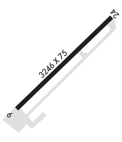
Runway Identifications
Runway Identification: 06/24Length: 3246 ft
Width: 75 ft
Surface: ASPHALT-GOOD CONDITION
Edge lights: Medium IntensityTreatment: NONE
| | Runway: 06 | | Runway: 24 |
| Mag heading: | 62° | Mag heading: | 242° |
| Rwy Slope: | -.08% Down | Rwy Slope: | .08% Up |
| Approach: | | Approach: | |
| Pattern: | Left Traffic | Pattern: | Right Traffic |
| Markings: | NONPRECISION INSTRUMENT | Markings: | NONPRECISION INSTRUMENT |
| Marking Condition: | GOOD | Marking Condition: | GOOD |
| Arresting Dev: | | Arresting Dev: | |
| Lat & Long: | N4104.4 W07155.5 | Lat. & Long.: | N4104.8 W07155.0 |
| Elev: | 6.8 ft. MSL | Elev: | 4.3 ft. MSL |
| TCH: | 45 ft. AGL | TCH: | 24 ft. AGL |
| Visual Glide Path: | 3.83 degrees | Visual Glide Path: | 4.00 degrees |
| Displaced Threshold: | 302 feet | Displaced Threshold: | 668 feet |
| Touchdown Zone: | YES | Touchdown Zone: | YES |
| Touchdown Elev.: | 6.1 feet | Touchdown Elev.: | 6.8 feet |
| Visual Glide Slope: | 2-Light PAPI on RIGHT side of Runway; PAPI RWY 6 TEMP OTS. | Visual Glide Slope: | 2-Light PAPI on LEFT side of Runway |
| RVR Equipment: | | RVR Equipment: | |
| RVV Equipment: | NO | RVV Equipment: | NO |
| Approach Lights: | | Approach Lights: | |
| REIL: | NO | REIL: | NO |
| Centerline Lights: | NO | Centerline Lights: | NO |
| Touchdown lights: | NO | Touchdown lights: | NO |
| Runway Category: | Runway with a Non-precision Approach | Runway Category: | Runway with a Visual Approach |
| Declared Distances: | | Declared Distances: | |
| Obstructions: | TREES | Obstructions: | HILL |
| Marked: | NOT Marked/Lighted | Marked: | NOT Marked/Lighted |
| Clearance slope: | RWY 06, 33 FT POLE, 212 FT FM RWY, 232 FT RT, CLNC SLP 15:1 TO DTHR. 15 FT ROAD 300 FT FM RWY, PERPENDICULAR TO EXTD RWY CNTRLN. | Clearance slope: | RWY 24, CLNC SLP 26:1 TO DTHR. |
| Obstruction height: | 28 feet AGL | Obstruction height: | 35 feet AGL |
| Dist. from runway: | 200 feet | Dist. from runway: | 200 feet |
| Centerline offset: | 66 left of centerline | Centerline offset: | 30 feet right of centerline |
| Comments: | RWY 06, 5 FT FENCE, 200 FT FM THLD, 200 FT RT. 15 FT TREES, 117 FT FM THLD, 205 FT RT. 30 FT TREES, 0-200 FT FM THLD, 50 FT - 70 FT LT. | Comments: | RWY 24, 25FT - 35FT TREES AND TERRAIN, 0-200 FT FM RWY, 200 FT RT TO 250 FT LT. |

