Current Weather/Notams (Metars, TAFs, Notams, NWS Forecast, PIREPS, and nearby weather)
Customs Information Send updates to Support@FltPlan.com
Customs Not Available
Database effective 05/16/2024
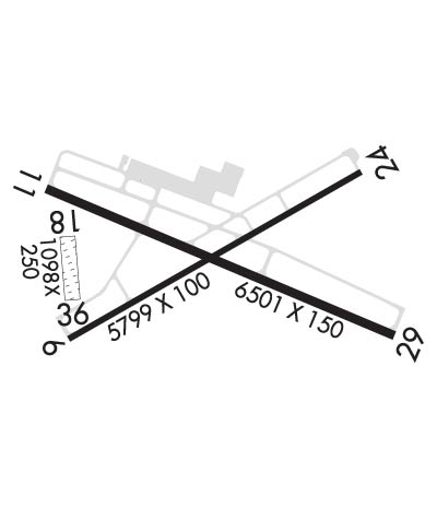
Airport Diagram might not be current.
|
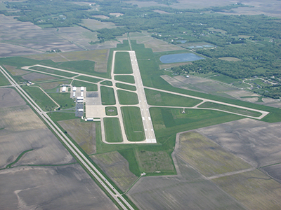
| Facility Name: | COLES COUNTY MEML |
| City Name: | MATTOON/CHARLESTON |
| County: | COLES |
| State abbrev: | IL |
| State Name: | ILLINOIS |
| | |
| Ownership: | PUBLICLY OWNED |
| Use: | OPEN TO THE PUBLIC |
| Owner's Name: | COLES COUNTY AIRPORT AUTHORITY |
| Address: | 432 AIRPORT ROAD |
| | MATTOON, IL 61938 |
| Owner's Phone: | 217-234-7120 |
| | |
| Manager's Name: | ANDREW FEARN |
| Address: | 432 AIRPORT ROAD |
| | MATTOON, IL 61938 |
| Phone: | 217-234-7120 |
| | |
| FAA Region: | GREAT LAKES |
| FAA Field Office: | CHI |
Runway Identifications
Runway Identification: 06/24Length: 5799 ft
Width: 100 ft
Surface: ASPHALT-GOOD CONDITION
Edge lights: Medium IntensityTreatment: GROOVED
Weight: PCN 23 /F/D/X/U
| | Runway: 06 | | Runway: 24 |
| Mag heading: | 63° | Mag heading: | 243° |
| Rwy Slope: | -.12% Down | Rwy Slope: | .12% Up |
| Approach: | | Approach: | |
| Pattern: | Right Traffic | Pattern: | Left Traffic |
| Markings: | NONPRECISION INSTRUMENT | Markings: | NONPRECISION INSTRUMENT |
| Marking Condition: | GOOD | Marking Condition: | GOOD |
| Arresting Dev: | | Arresting Dev: | |
| Lat & Long: | N3928.4 W08817.3 | Lat. & Long.: | N3928.9 W08816.2 |
| Elev: | 718.8 ft. MSL | Elev: | 712.1 ft. MSL |
| TCH: | 41 ft. AGL | TCH: | 46 ft. AGL |
| Visual Glide Path: | 3.00 degrees | Visual Glide Path: | 3.00 degrees |
| Displaced Threshold: | No | Displaced Threshold: | No |
| Touchdown Zone: | YES | Touchdown Zone: | YES |
| Touchdown Elev.: | 722.3 feet | Touchdown Elev.: | 718.5 feet |
| Visual Glide Slope: | 4-BOX VASI ON LEFT SIDE OF RUNWAY | Visual Glide Slope: | 4-BOX VASI ON LEFT SIDE OF RUNWAY |
| RVR Equipment: | | RVR Equipment: | |
| RVV Equipment: | NO | RVV Equipment: | NO |
| Approach Lights: | | Approach Lights: | |
| REIL: | YES | REIL: | YES |
| Centerline Lights: | NO | Centerline Lights: | NO |
| Touchdown lights: | NO | Touchdown lights: | NO |
| Runway Category: | Runway with a Non-precision Approach having visibility minimums greater than 3/4 mile | Runway Category: | Runway with a Non-precision Approach having visibility minimums greater than 3/4 mile |
| Declared Distances: | TORA:5799' TODA:5799' ASDA:5799' LDA:5799' | Declared Distances: | TORA:5799' TODA:5799' ASDA:5799' LDA:5799' |
| Obstructions: | TREE | Obstructions: | |
| Marked: | NOT Marked/Lighted | Marked: | |
| Clearance slope: | 37:1 | Clearance slope: | 50:1 |
| Obstruction height: | 52 feet AGL | Obstruction height: | |
| Dist. from runway: | 2139 feet | Dist. from runway: | |
| Centerline offset: | 103 left of centerline | Centerline offset: | |
| Comments: | | Comments: | |
Runway Identification: 11/29Length: 6501 ft
Width: 150 ft
Surface: ASPHALT-GOOD CONDITION
Edge lights: High IntensityTreatment: GROOVED
Weight: PCN 51 /F/D/X/U
| | Runway: 11 | | Runway: 29 |
| Mag heading: | 116° | Mag heading: | 296° |
| Rwy Slope: | .00% Down | Rwy Slope: | .00% Up |
| Approach: | | Approach: | ILS |
| Pattern: | Right Traffic | Pattern: | Left Traffic |
| Markings: | PRECISION INSTRUMENT | Markings: | PRECISION INSTRUMENT |
| Marking Condition: | FAIR | Marking Condition: | FAIR |
| Arresting Dev: | | Arresting Dev: | |
| Lat & Long: | N3928.9 W08817.4 | Lat. & Long.: | N3928.5 W08816.1 |
| Elev: | 714.4 ft. MSL | Elev: | 714.3 ft. MSL |
| TCH: | 26 ft. AGL | TCH: | |
| Visual Glide Path: | 3.00 degrees | Visual Glide Path: | |
| Displaced Threshold: | No | Displaced Threshold: | No |
| Touchdown Zone: | YES | Touchdown Zone: | YES |
| Touchdown Elev.: | 718.4 feet | Touchdown Elev.: | 718.1 feet |
| Visual Glide Slope: | 4-Light PAPI on LEFT side of Runway | Visual Glide Slope: | |
| RVR Equipment: | | RVR Equipment: | |
| RVV Equipment: | NO | RVV Equipment: | NO |
| Approach Lights: | | Approach Lights: | MALSR - 1,400 foot medium intensity approach lighting system with runway alignment indicator lights |
| REIL: | YES | REIL: | NO |
| Centerline Lights: | NO | Centerline Lights: | NO |
| Touchdown lights: | NO | Touchdown lights: | NO |
| Runway Category: | D | Runway Category: | Precision Instrument Runway |
| Declared Distances: | TORA:6501' TODA:6501' ASDA:6501' LDA:6501' | Declared Distances: | TORA:6501' TODA:6501' ASDA:6501' LDA:6501' |
| Obstructions: | | Obstructions: | TREE |
| Marked: | | Marked: | NOT Marked/Lighted |
| Clearance slope: | 50:1 | Clearance slope: | 42:1 |
| Obstruction height: | | Obstruction height: | 56 feet AGL |
| Dist. from runway: | | Dist. from runway: | 2592 feet |
| Centerline offset: | | Centerline offset: | 780 feet right of centerline |
| Comments: | | Comments: | |
Runway Identification: 18/36Length: 1098 ft
Width: 250 ft
Surface: GRASS
Edge lights: Treatment: NONE
| | Runway: 18 | | Runway: 36 |
| Mag heading: | 178° | Mag heading: | 358° |
| Rwy Slope: | .38% Up | Rwy Slope: | -.38% Down |
| Approach: | | Approach: | |
| Pattern: | Right Traffic | Pattern: | Left Traffic |
| Markings: | | Markings: | |
| Marking Condition: | CORNER STONE MARKERS; LENGTH & WIDTH. | Marking Condition: | |
| Arresting Dev: | | Arresting Dev: | |
| Lat & Long: | N3928.7 W08817.3 | Lat. & Long.: | N3928.6 W08817.3 |
| Elev: | 714.7 ft. MSL | Elev: | 718.9 ft. MSL |
| TCH: | | TCH: | |
| Visual Glide Path: | | Visual Glide Path: | |
| Displaced Threshold: | No | Displaced Threshold: | No |
| Touchdown Zone: | YES | Touchdown Zone: | YES |
| Touchdown Elev.: | 718.9 feet | Touchdown Elev.: | 718.9 feet |
| Visual Glide Slope: | | Visual Glide Slope: | |
| RVR Equipment: | | RVR Equipment: | |
| RVV Equipment: | NO | RVV Equipment: | NO |
| Approach Lights: | | Approach Lights: | |
| REIL: | NO | REIL: | NO |
| Centerline Lights: | NO | Centerline Lights: | NO |
| Touchdown lights: | NO | Touchdown lights: | NO |
| Runway Category: | Runway with a Visual Approach | Runway Category: | Runway with a Visual Approach |
| Declared Distances: | TORA:1080' TODA:1080' ASDA:1080' LDA:1080' | Declared Distances: | TORA:1080' TODA:1080' ASDA:1080' LDA:1080' |