KMSY

ARMSTRONG NEW ORLEANS INTL
NEW ORLEANS
LA
Time Zone: Central
Lat: N 2959.6
Long: W 09015.5
Elev: 4
Var: +01
Longest Runway: 10104
Clr Del: 120.92/120.92
Dept. ATIS: 127.55
Arr. ATIS: 127.55
Ground: 121.9
Tower: 119.5

FBO & Flight Services info for KMSY

FBOs: Update your Fuel Prices
Atlantic Aviation is your premier aviation service provider with more than 100 locations in North America, including Hawaii and the Caribbean. We provide standard ground services you'd expect, with a detailed focus on ensuring an unforgettable customer experience.
Ph: 504-466-1700 Fax: 504-465-9699 Freq: 130.37WebsiteE-Mail
                             
Service
Jet
100LL
SAF
MoGas
Full8.038.61    Last Update: 04/25/2024 13:10:33

Self        
Misc. Info: All prices are 'Out The Door', call for volume discounts
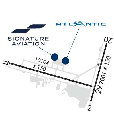
Address: 749 LOCKHEED DR,   KENNER, LA 70062

  click here  
Wander through the cobblestone streets of the historic French Quarter, or visit the top flight art museums and galleries that dot this city. Enjoy world-class music and architecture that is unabashedly opulent and quirky. This is New Orleans -- from the grand and elegant to the funky and fun.
Ph: 504-468-7722 Fax: 504-468-9928 Freq: 130.6WebsiteE-Mail
                     
Service
Jet
100LL
SAF
MoGas
Fuel Avail: PRIST+ $0.06/gal 24 hrs.
Full8.138.50    Last Update: 04/25/2024 09:46
PRICES GUARANTEED by FBO.
Self        
Misc. Info: Discounts offered and Contract FuelAddress: 2200 ABERDEEN ST,   KENNER, LA 70062

ASOSPh: 504-461-5345
-
-
 
ATISPh: 504-471-4417
-
-
 
If you are an FBO, call 1-203-262-1700 to update your info or email: FltPlan.Advertising@garmin.com
Advertise your FBO on FltPlan.com
FBOs at nearby airports who want your business:
KHDC


  click here  
Pierce Aviation, (formerly known as Hammond Air Center), is a true FBO. We pride ourselves in offering personalized service and high-end amenities at a reasonable price. Our FBO is operated by professional pilots. We offer outstanding service and modern facilities. Come see what happens when a couple of pilots try their hand at building an FBO and actually pull it off!
Ph: 1-985-345-3030WebsiteE-MailFax: 1-985-249-2643Freq: 129.45
KHUM

Only a 15-minute flight to HUM, Apex Jet Center is a full service FBO with the largest ramp on the field and hanger accommodations for over 40 planes. Mechanics are on duty during operational hours. Other services offered: Shell products, passenger and pilot's lounge, aircraft parking, 3 courtesy cars, oxygen service, aerial tours, and more! Apex Aero offers charter services.
Ph: 985-851-5737 WebsiteE-MailFax: 985-857-9473 Freq: 131.3

Runway & Approach Info for KMSY
Rwy
Length
Land Dist**
Approach*
  Rwy
Length
Land Dist**
Approach*
02
7001x150  7001'          
ILS/DME
 111.70 - 016°  
  
20
  7001x150  7001'          
LOC/DME
 111.70 - 196°  
11
10104x150  10104'          
ILS/DME
 109.90 - 106°  
  
29
  10104x150  9800'          
ILS/DME
 109.90 - 286°  
 * only ILS, LOC, LDA, and SDF approaches to a specific runway are shown
** For any Declared Landing Distance Available, please see A/FD or Approach plates
Runway Weight Capability (lbs.) Help
Runway IDSingle WheelDouble WheelDouble Tandem WheelDual Double Wheel
02/2075,000180,000380,000N/A
11/2975,000180,000380,000N/A
These numbers are Advisory and are not limits.   The Airport Manager should have more accurate Weight Limits
Approach Charts
Approaches    
Current Weather/Notams
Customs Information Send updates to Support@FltPlan.com
Phone 504-467-1713
Fax 504-468-2708

Comments Mon-Sat 0800-1700 *2 hrs advance notice required *Call prior to 1430 on preceding weekday.
Database effective 05/16/2024
Airport Diagram of KMSY
Airport Diagram might not be current.

Facility Name: LOUIS ARMSTRONG NEW ORLEANS INTL
City Name: NEW ORLEANS
County: JEFFERSON
State abbrev: LA
State Name: LOUISIANA
   
Ownership: PUBLICLY OWNED
Use: OPEN TO THE PUBLIC
Owner's Name: CITY OF NEW ORLEANS
Address: PO BOX 20007
 NEW ORLEANS, LA 70141
Owner's Phone: 504-658-4900
  
Manager's Name: KEVIN DOLLIOLE
Address: PO BOX 20007
 NEW ORLEANS, LA 70141
Phone: (504) 303-7652
   
FAA Region: SOUTHWEST
FAA Field Office: LNM


Sunrise / Sunset times for LOUIS ARMSTRONG NEW ORLEANS INTL

DateSunriseSunset
04/25/24 Thursday6:2319:35
04/26/24 Friday6:2219:36
04/27/24 Saturday6:2119:36
04/28/24 Sunday6:2019:37
04/29/24 Monday6:1919:38
04/30/24 Tuesday6:1819:38
05/01/24 Wednesday6:1819:39
05/02/24 Thursday6:1719:40
05/03/24 Friday6:1619:40
05/04/24 Saturday6:1519:41
05/05/24 Sunday6:1419:42
05/06/24 Monday6:1319:42
05/07/24 Tuesday6:1319:43
05/08/24 Wednesday6:1219:43

Airport Facilities

Airport Attendance ScheduleCONTINUOUS
Airport Status OPERATIONAL (This Status can change at any time - please check NOTAMS)
Airport Lighting ScheduleSS-SR
Airport Storage AvailableTie Downs
Extra Services AvailableAir Freight, Cargo Handling
Wind IndicatorYES - (lighted)
Control TowerYES
CTAF Frequency
Unicom Frequency122.950
Rotating Beacon ColorWG
Segmented CircleNO
Landing FeeYES

Airport Inspection Data

Airport InspectedFEDERAL - performed by FAA AIRPORTS FIELD PERSONNEL
Inspection Date03/26/2024

Airport Services

Type of Fuel AvailableGrade 100LL, JET A (freeze point -40C)
Airframe Repair ServiceNONE
Power Plant Repair ServiceNONE

Geographic Data

LatitudeN2959.6
LongitudeW09015.5 (ESTIMATED)
Arpt Elevation3ft (SURVEYED)
Magnetic Variation01W
10 miles Wof NEW ORLEANS
Traffic Pattern Altitude
Sectional ChartNEW ORLEANS

Aircraft Data

Operations (Reported)YearlyAvg. Daily
General Aviation Transient 828323
General Aviation Local 00
Air Taxi 804822
Commerical 109422300
Commuter 00
Military 3851
Aircraft based on Field
General Aviation Singles 4
General Aviation Multi 1
Jet Aircraft 17
General Aviation Helicopters 7
Military Aircraft 0
Gliders 0
Ultralights 0

FAA Services

FSS on field NO
FSS tie-in DE RIDDER
FSS Phone 1-800-WX-BRIEF
Who issues Notams MSY
Notam D service at airport YES
ARTCC Name HOUSTON

Federal Status

Airport CertificationAIRPORT RECEIVING SCHEDULED AIR CARRIER SERVICE FROM CARRIERS CERTIFICATED BY THE CIVIL AERONAUTICS BOARD
Aircraft Rescue & Firefighting IndexAIRPORT HAS A CERTIFICATE UNDER CFR PART 139
Airport of EntryNo
Custom Landing RightsYES
Joint Civil/MilitaryNo
Military Landing rightsYES

Federal Agreements

NATIONAL PLAN OF INTEGRATED AIRPORT SYSTEMS (NPIAS)
GRANT AGREEMENTS UNDER FAAP/ADAP/AIP
ASSURANCES PURSUANT TO TITLE VI, CIVIL RIGHTS ACT OF 1964
AGREEMENT UNDER DLAND OR DCLA HAS EXPIRED.

Remarks

180 DEG & LOCKED WHEEL TURNS PROHIBITED ON ASPH SFC ACFT 12500 LBS & OVER.
FLOCKS OF BIRDS ON & IN VICINITY OF ARPT.
RY 11 NOISE SENSITIVE FOR DEP; AVBL FOR OPNL NECESSITY. ALL RYS NOISE SENSITIVE FOR ARR. ARRIVING TURBOJETS MUST MAKE 5 MILE FINAL APCH TO MINIMIZE NOISE.
ASSC IN USE. OPERATE TRANSPONDERS WITH ALTITUDE REPORTING MODE AND ADS-B (IF EQUIPPED) ENABLED ON ALL AIRPORT SURFACES.
TWY G BTN RWY 11/29 AND TWY S SFC MOV GUIDANCE AND CTL SYSTEM U/S PERM
Airport Communications & Frequencies:
ATIS Frequencies:   Hours(local) of Operation: CONTINUOUS
127.55
NEW ORLEANS Tower Frequencies:   Hours(local) of operation: CONTINUOUS   
119.5
254.3
NEW ORLEANS Ground Frequencies:
121.9
273.525
Clearance Delivery Frequencies:
120.925
120.925
Pre-Taxi Clearance Frequencies:
120.925
Emergency Frequencies:
121.5
243.0
Unicom Frequency:
122.950
NEW ORLEANS Primary Approach Frequencies:   Hours(local) of operation: CONTINUOUS   
125.5 ;WEST
133.15 ;EAST
290.3 ;EAST
350.35 ;WEST
Part-time Approach Frequencies:  
269.2
NEW ORLEANS Primary Departure Frequencies:   Hours(local) of operation: CONTINUOUS   
125.5 ;WEST
133.15 ;EAST
290.3 ;EAST
350.35 ;WEST
Class B Frequencies:
123.85 ;SE & SOUTH
125.5 ;WEST
133.15 ;NORTH & EAST
256.9 ;SE & SOUTH
290.3 ;NORTH & EAST
350.35 ;WEST
Runway Identifications
Runway Identification: 02/20
Length: 7001 ft
Width: 150 ft
Surface: CONCRETE-GOOD CONDITION
Edge lights: High Intensity

Treatment: GROOVED
Weight: PCN 64 /R/C/W/T

 Runway: 02   Runway: 20
Mag heading: 16°Mag heading: 196°
Rwy Slope: -.06% DownRwy Slope: .06% Up
Approach: ILS/DMEApproach: LOC/DME
Pattern: Left TrafficPattern: Left Traffic
Markings: PRECISION INSTRUMENTMarkings: PRECISION INSTRUMENT
Marking Condition: GOODMarking Condition: GOOD
Arresting Dev: Arresting Dev:
Lat & Long: N2959.1  W09015.1Lat. & Long.: N3000.2  W09014.7
Elev: 1.8 ft. MSLElev: -2.4 ft. MSL
TCH: 52 ft. AGLTCH: 52 ft. AGL
Visual Glide Path: 3.00 degreesVisual Glide Path: 3.00 degrees
Displaced Threshold: NoDisplaced Threshold: No
Touchdown Zone: YESTouchdown Zone: YES
Touchdown Elev.: 2.1 feetTouchdown Elev.: -0.6 feet
Visual Glide Slope: 4-Light PAPI on LEFT side of RunwayVisual Glide Slope: 4-Light PAPI on LEFT side of Runway
RVR Equipment: TOUCHDOWN-ROLLOUTRVR Equipment: TOUCHDOWN-ROLLOUT
RVV Equipment: NORVV Equipment: NO
Approach Lights: RLLSApproach Lights: MALS - 1,400 foot medium intensity approach lighting system
REIL: NOREIL: NO
Centerline Lights: YESCenterline Lights: YES
Touchdown lights: NOTouchdown lights: NO
Runway Category: Precision Instrument RunwayRunway Category: Runway with a Non-precision Approach having visibility minimums greater than 3/4 mile
Declared Distances: TORA:7001' TODA:7001' ASDA:7001' LDA:7001'Declared Distances: TORA:7001' TODA:7001' ASDA:7001' LDA:7001'
Obstructions: ROADObstructions: ROAD
Marked: LIGHTEDMarked: LIGHTED
Clearance slope: Clearance slope:
Obstruction height: 12 feet AGLObstruction height: 13 feet AGL
Dist. from runway: 200 feetDist. from runway: 200 feet
Centerline offset: 365 right of centerlineCenterline offset: 289 feet left of centerline
Comments: +12 FT ROAD PARALLEL TO AND 365 FT RIGHT OF CNTRLN 0-200 FT FM RY END.Comments: +13 FT ROAD PARALLEL TO AND 289 FT LEFT OF CNTRLN 0-200 FT FM RY END.
Runway Identification: 11/29
Length: 10104 ft
Width: 150 ft
Surface: CONCRETE-GOOD CONDITION
Edge lights: High Intensity

Treatment: GROOVED
Weight: PCN 123/R/C/W/T

 Runway: 11   Runway: 29
Mag heading: 106°Mag heading: 286°
Rwy Slope: -.02% DownRwy Slope: .02% Up
Approach: ILS/DMEApproach: ILS/DME
Pattern: Left TrafficPattern: Left Traffic
Markings: PRECISION INSTRUMENTMarkings: PRECISION INSTRUMENT
Marking Condition: GOODMarking Condition: GOOD
Arresting Dev: Arresting Dev:
Lat & Long: N2959.8  W09016.9Lat. & Long.: N2959.4  W09015.1
Elev: 3.7 ft. MSLElev: 1.3 ft. MSL
TCH: 55 ft. AGLTCH: 68 ft. AGL
Visual Glide Path: 2.80 degreesVisual Glide Path: 3.00 degrees
Displaced Threshold: NoDisplaced Threshold: 304 feet
Touchdown Zone: YESTouchdown Zone: YES
Touchdown Elev.: 3.7 feetTouchdown Elev.: 2.0 feet
Visual Glide Slope: 4-Light PAPI on RIGHT side of RunwayVisual Glide Slope: 4-Light PAPI on RIGHT side of Runway
RVR Equipment: TOUCHDOWN-MIDFIELD-ROLLOUTRVR Equipment: TOUCHDOWN-MIDFIELD-ROLLOUT
RVV Equipment: NORVV Equipment: NO
Approach Lights: ALSF2 - standard 2,400 foot high intensity approach lighting system with sequenced flashers, Category II or IIIApproach Lights: MALSR - 1,400 foot medium intensity approach lighting system with runway alignment indicator lights
REIL: NOREIL: NO
Centerline Lights: YESCenterline Lights: YES
Touchdown lights: YESTouchdown lights: NO
Runway Category: Precision Instrument RunwayRunway Category: Precision Instrument Runway
Declared Distances: TORA:10104' TODA:10104' ASDA:9800' LDA:9800'Declared Distances: TORA:10104' TODA:10104' ASDA:10104' LDA:9800'
Obstructions: Obstructions: TREE
Marked: Marked: NOT Marked/Lighted
Clearance slope: 50:1Clearance slope: 25:1; +53 FT TREE, 1557 FT DIST, 694 FT R, 30:1 BASED ON DSPLCD THLD.
Obstruction height: Obstruction height: 53 feet AGL
Dist. from runway: Dist. from runway: 1557 feet
Centerline offset: Centerline offset: 694 feet right of centerline
Comments: Comments:
C:123/P: